world.wikisort.org - Thailand
Plai Phraya (Thai: ปลายพระยา, pronounced [plāːj pʰrā.jāː]) is a district (amphoe) in Krabi province, Thailand.
Plai Phraya
ปลายพระยา | |
|---|---|
District | |
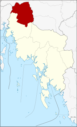 District location in Krabi province | |
| Coordinates: 8°32′0″N 98°51′46″E | |
| Country | Thailand |
| Province | Krabi |
| Seat | Plai Phraya |
| Area | |
| • Total | 433.4 km2 (167.3 sq mi) |
| Population (6 November 2002) | |
| • Total | 35,434 |
| • Density | 81.8/km2 (212/sq mi) |
| Time zone | UTC+7 (ICT) |
| Postal code | 81160 |
| Geocode | 8106 |
Geography
Neighboring districts are (from the north clockwise): Phanom, Phrasaeng, Chai Buri (all Surat Thani province); Khao Phanom and Ao Luek of Krabi Province; and Thap Put of Phang Nga province.
Khlong Phraya Wildlife Sanctuary is on the Surat Thani Province border.
History
The minor district (king amphoe) Plai Phraya was created on 15 June 1973, when the three tambons, Plai Phraya, Khao Khen, and Khao To, were split off from Ao Luek district.[1] It was upgraded to a full district on 12 April 1977.[2]
Administration
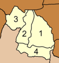
The district is divided into four sub-districts (tambons), which are further subdivided into 33 villages (mubans). Plai Phraya has township (thesaban tambon) status, covering parts of tambon Plai Phraya. Each of the tambons is administrated by a tambon administrative organization (TAO).
|
 |
References
- ประกาศกระทรวงมหาดไทย เรื่อง แบ่งท้องที่อำเภออ่าวลึก จังหวัดกระบี่ ตั้งเป็นกิ่งอำเภอปลายพระยา (PDF). Royal Gazette (in Thai). 90 (67 ง): 1840. June 12, 1973.
- พระราชกฤษฎีกาตั้งอำเภอปลายพระยา อำเภอห้วยเม็ก อำเภอละแม อำเภอแม่จริม อำเภอหนองกี่ อำเภอโคกปีบ อำเภอเกาะพะงัน อำเภอสนม อำเภอโซ่พิสัย อำเภอโนนสะอาด และอำเภอนาจะหลวย พ.ศ. ๒๕๒๐ (PDF). Royal Gazette (in Thai). 94 (31 ก): 326–330. April 12, 1977.
External links
This Krabi Province location article is a stub. You can help Wikipedia by expanding it. |
Другой контент может иметь иную лицензию. Перед использованием материалов сайта WikiSort.org внимательно изучите правила лицензирования конкретных элементов наполнения сайта.
WikiSort.org - проект по пересортировке и дополнению контента Википедии