world.wikisort.org - Sri_Lanka
Cinnamon Gardens (Sinhala: කුරුඳු වත්ත Kurundu Vaththa, Tamil: கறுவாத் தோட்டம்) is an affluent neighbourhood in Colombo, Sri Lanka located 3 kilometers south-east from Colombo's centre. Cinnamon Gardens is named from the former cinnamon plantation in this area. In the year 1789, there were 289 acres (1.17 km2) of cinnamon trees in the gardens.
This article uses bare URLs, which are uninformative and vulnerable to link rot. (September 2022) |
Cinnamon Gardens
කුරුඳු වත්ත கறுவாத் தோட்டம் | |
|---|---|
Suburb | |
       From top left to right: Colombo Racecourse seen along Reid Avenue, Independence Memorial Hall, Nelum Pokuna Mahinda Rajapaksa Theatre, Bandaranaike Memorial International Conference Hall, Arcade Independence Square, Royal College, Viharamahadevi Park looking towards the Colombo Municipal Council | |
 Cinnamon Gardens Location in Location in Greater Colombo | |
| Coordinates: 6°54′24″N 79°51′48″E | |
| Country | Sri Lanka |
| Province | Western Province |
| District | Colombo District |
| Time zone | UTC+5:30 (Sri Lanka Standard Time Zone) |
| Postal Code | 00700[1] |
At present, Cinnamon Gardens is the location of the Prime Minister's Office, Independence Hall, Colombo Town Hall and National Museum as well as numerous foreign embassies and high commissions, located down streets lined with fine trees and mansions that are home to the country's elite.[2][3][4]
It is also the location of the Colombo Department of Meteorology and its observatory.[5]
Demographic
Cinnamon Gardens is a multi-religious and multi-ethnic area. The major ethnic communities in Cinnamon Gardens are Sinhalese and Tamils. Ethnic minorities include Burghers and Sri Lankan Moors. Religions include Buddhism, Hinduism, Islam, Christianity and various other religions and beliefs to a lesser extent.
Schools
- Bishop's College (Sri Lanka)
- Buddhist Ladies' College[6]
- Carey College, Colombo
- Colombo International School
- D. S. Senanayake College
- Ladies' College, Colombo
- Musaeus College
- Royal College Colombo
- Sirimavo Bandaranaike Vidyalaya
- St Bridget's Convent, Colombo
- Thurstan College
- Wycherley International School
- Stafford International School
Universities
- University of Colombo
- University of the Visual & Performing Arts
Sporting venues
- Singhalese Sports Club Cricket Ground
- Royal College Sports Complex
- D.S. Senanayake College Sports Complex
- Thurstan College Cricket Grounds[7][8]
- Bloomfield Cricket and Athletic Club
- Ceylonese Rugby & Football Club Grounds
- Colombo Cricket Club Ground
- Colombo Racecourse
Buildings
- Lighthouse
- Jefferson House
- Arcade Independence Square
Places of interest


- National Museum of Colombo
- Viharamahadevi Park
- Nelum Pokuna Mahinda Rajapaksa Theatre
- SSC Cricket Ground
- Colombo Race Course
- Arcade Independence Square
- Independence Square
- Colombo Municipal Council (Town Hall)
- Colombo public Library
- BMICH
- Planetarium
- National Art Gallery, Sri Lanka
- World War Memorial Park
- Lionel Wendt Art Centre
Diplomatic missions
- High Commission of Australia
- High Commission of Canada
- Royal Embassy of Netherlands
- High Commission of South Africa
- Embassy of Iran
- Embassy of China
- Embassy of Vietnam
- Embassy of Qatar
- Embassy of the Republic of France
- Embassy of Indonesia
- Embassy of Japan
- Embassy of Kuwait
- Embassy of Myanmar (Burma)
- Embassy of the Islamic Republic of Pakistan
- Embassy of Romania
- Embassy of Russia
- Embassy of the Kingdom of Saudi Arabia
- Embassy of Switzerland
- Embassy of the United Arab Emirates
- High Commission of the United Kingdom
- Royal Embassy of Thailand
- High Commission of Bangladesh
- Embassy of Brazil
- Embassy of Libya
- Embassy of the Republic of South Korea
Gallery
 Independence Hall
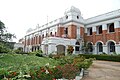 Royal College Colombo
 Arcade Independence Square
 Thurstan College Colombo
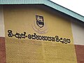 D. S. Senanayake College
 Sirimavo Bandaranaike Vidyalaya


See also
- Rajakeeya Mawatha
- Kumarathunga Munidasa Mawatha
 Sri Lanka portal
References
- "Cinnamon Gardens None - Sri Lanka Postal Codes - Mohanjith". Archived from the original on 2012-09-05. Retrieved 2009-03-15.
- "Port of Colombo".
- http://www.lankainfo.com/travelinformation/cinnamongarden.htm
- "Ceylon Road in the Cinnamon Gardens-Colombo-SriLanka". Archived from the original on 2009-03-01. Retrieved 2009-03-15.
- "Meteorological Department - Colombo".
- Buddhist Ladies' College 56th Founder's Day Archived 2013-02-19 at archive.today
- Thurstan College Cricket ground in Colombo 7
- Thurstan College Ground
Places adjacent to Cinnamon Gardens | ||||||||||||||||
|---|---|---|---|---|---|---|---|---|---|---|---|---|---|---|---|---|
| ||||||||||||||||
Другой контент может иметь иную лицензию. Перед использованием материалов сайта WikiSort.org внимательно изучите правила лицензирования конкретных элементов наполнения сайта.
WikiSort.org - проект по пересортировке и дополнению контента Википедии