world.wikisort.org - Spain
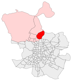
Valverde is an administrative neighborhood (barrio) of Madrid belonging to the district of Fuencarral-El Pardo. It has an area of 8.977802 km2 (3.466349 sq mi).[1] As of 1 March 2020, it has a population of 65,022.[2] The historic centre of Fuencarral (Fuencarral Pueblo), belongs to the Valverde neighborhood.[3] The Hospital Universitario Ramón y Cajal is also located in the neighborhood.
Valverde | |
|---|---|
City neighborhood | |
 | |
 | |
| Country | Spain |
| Region | Madrid |
| Municipality | Madrid |
| District | Fuencarral-El Pardo |
| Area | |
| • Total | 8.977802 km2 (3.466349 sq mi) |
| Population (2020) | |
| • Total | 65,022 |
| • Density | 7,200/km2 (19,000/sq mi) |
References
- "Callejero vigente. Barrios". Ayuntamiento de Madrid.
- "Población por distrito y barrio". Ayuntamiento de Madrid. Retrieved 20 March 2020.
- "Los nombres no oficiales de los barrios del norte de Madrid". temploconsulting.com. 12 June 2018.
This article about a location in the Community of Madrid, Spain is a stub. You can help Wikipedia by expanding it. |
Wikimedia Commons has media related to Valverde neighborhood, Madrid.
Authority control | |
|---|---|
| General |
|
| National libraries | |
На других языках
- [en] Valverde (Madrid)
[es] Valverde (Madrid)
Valverde es un barrio del norte de la villa de Madrid (España) perteneciente al distrito de Fuencarral-El Pardo. Limita al norte con el barrio de El Goloso, al oeste con Mirasierra y al suroeste con La Paz.Текст в блоке "Читать" взят с сайта "Википедия" и доступен по лицензии Creative Commons Attribution-ShareAlike; в отдельных случаях могут действовать дополнительные условия.
Другой контент может иметь иную лицензию. Перед использованием материалов сайта WikiSort.org внимательно изучите правила лицензирования конкретных элементов наполнения сайта.
Другой контент может иметь иную лицензию. Перед использованием материалов сайта WikiSort.org внимательно изучите правила лицензирования конкретных элементов наполнения сайта.
2019-2026
WikiSort.org - проект по пересортировке и дополнению контента Википедии
WikiSort.org - проект по пересортировке и дополнению контента Википедии