world.wikisort.org - Spain
Los Realejos is a town and a municipality in the northern part of the island of Tenerife, which is the biggest of the Canary Islands. It is part of the province of Santa Cruz de Tenerife, Spain. The town is located 2 km (1.2 mi) from the north coast, 5 km (3.1 mi) southwest of Puerto de la Cruz, 6 km (3.7 mi) west of La Orotava, and 34 km (21 mi) southwest of the island's capital Santa Cruz de Tenerife. The inhabitants are known in Spanish as realejeros.
This article has multiple issues. Please help improve it or discuss these issues on the talk page. (Learn how and when to remove these template messages)
|
Los Realejos | |
|---|---|
Municipality | |
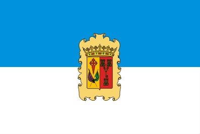 Flag  Coat of arms | |
 Los Realejos in Tenerife | |
 Los Realejos Location in Tenerife  Los Realejos Los Realejos (Canary Islands)  Los Realejos Los Realejos (Spain, Canary Islands) | |
| Coordinates: 28°21′N 16°36′W | |
| Country | |
| Autonomous Community | |
| Province | Santa Cruz de Tenerife |
| Island | Tenerife |
| Government | |
| • Mayor | Manuel Domínguez (PP) |
| Area | |
| • Total | 57 km2 (22 sq mi) |
| Elevation (AMSL) | 420 m (1,380 ft) |
| Population (2018)[1] | |
| • Total | 36,405 |
| • Density | 640/km2 (1,700/sq mi) |
| Time zone | UTC+0 (CET) |
| • Summer (DST) | UTC+1 (CEST (GMT +1)) |
| Postal code | 38410\34418 |
| Area code(s) | +34 (Spain) + 922 (Tenerife) |
| Website | www.losrealejos.es |
 | |
| Click on the map for a fullscreen view | |
The population consists of 37,970 (2013[2]), its density being 670/km2 (1,700/sq mi) and the area is 57.08 km2 (22.04 sq mi). The highest peak is 420 m (1,380 ft). Los Realejos is the western terminus of the TF-5 motorway.
The town is split into two distinct areas or districts:
- Realejo Alto (Upper Realejo)
- Realejo Bajo (Lower Realejo)
These areas are distinct from each other in terms of their geography (a large deep ravine splits both) and their history (during the Spanish conquest of the island, the indigenous people Guanches had a settlement in the lower area of the town. In contrast, the Spaniards occupied the upper area). Furthermore, each area has its own Baroque church, both of which were built shortly after completing the Spanish conquest. The municipality was originally founded and known as Realejo de Arriba.
The town governed by its local council also includes other smaller villages such as Palo Blanco, Cruz Santa, Mocan, Icod de Alto, and Tigaiga. Over the years, an increase in population and housing have merged into what appears to be one big town nowadays.
Los Realejos also has a few beaches of note, Playa de El Socorro being the most popular one, not only with the locals but also with tourists. Other beaches like Playa de Castro and Playa de Fajana are worthy of mention, albeit they are slightly less accessible than El Socorro. Los Realejos is the home of the English language newspaper the Tenerife News. Los Realejos boasts the Shrine of Our Lady of Mount Carmel, which is the main Marian shrine in northern Tenerife.
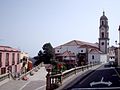 Iglesia de Nuestra Señora de la Concepción
 Water elevator
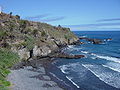 Playa de Castro


Historical population
| Year | Population |
|---|---|
| 1991 | 29,829 |
| 1996 | 32,599 |
| 2001 | 33,438 |
| 2002 | 35,299 |
| 2003 | 35,799 |
| 2004 | 35,756 |
| 2009 | 37,559 |
| 2013 | 37,970 |
| 2014 | 36,860 |
| 2015 | 36,276 |
| 2016 | 36,149 |
| 2017 | 36,218 |
| 2018 | 36,405 |
| 2019 | 36,402 |
Education
The British School of Tenerife has its Trinity Campus in Los Realejos.[3]
Natives of Los Realejos
- José Viera y Clavijo (December 28, 1731, Las Palmas de Gran Canaria - February 21, 1813), a writer, botanist, and a historian.
See also
- List of municipalities in Santa Cruz de Tenerife
References
- Municipal Register of Spain 2018. National Statistics Institute.
- Instituto Canario de Estadística Archived 2014-04-19 at the Wayback Machine
- "Find Us Archived 2016-02-17 at the Wayback Machine." British School of Tenerife. Retrieved on 13 February 2016. "TRINITY Camino Montijo, 16; 38410 Los Realejos"
External links
Places adjacent to Los Realejos | ||||||||||||||||
|---|---|---|---|---|---|---|---|---|---|---|---|---|---|---|---|---|
| ||||||||||||||||
Municipalities in the province of Santa Cruz de Tenerife | ||
|---|---|---|
| Tenerife |
| |
| La Palma |
| |
| La Gomera |
| |
| El Hierro |
| |
Authority control | |
|---|---|
| General |
|
| National libraries | |
| Other |
|
На других языках
- [en] Los Realejos
[es] Los Realejos
Los Realejos es un municipio español perteneciente a la isla de Tenerife, en la provincia de Santa Cruz de Tenerife, comunidad autónoma de Canarias. La capital municipal está localizada en el casco urbano de Los Realejos, situado a unos 327 m s. n. m..[ru] Лос-Реалехос
Лос-Реалехос (исп. Los Realejos) — населённый пункт и муниципалитет в Испании, входит в провинцию Санта-Крус-де-Тенерифе в составе автономного сообщества Канарские острова. Находится на острове Тенерифе. Занимает площадь 57,08 км². Население 37658 человек (на 2010 год).Другой контент может иметь иную лицензию. Перед использованием материалов сайта WikiSort.org внимательно изучите правила лицензирования конкретных элементов наполнения сайта.
WikiSort.org - проект по пересортировке и дополнению контента Википедии