world.wikisort.org - Spain
Agulo is located on the north coast of the island of La Gomera in the province of Santa Cruz de Tenerife of the Canary Islands. It is located 13 km northwest of the capital San Sebastián de la Gomera. The population was 1,100 in 2013.[3]
Agulo | |
|---|---|
Municipality | |
 View of Agulo | |
 Flag  Coat of arms | |
 Location in La Gomera | |
 Agulo Location in the Canary Islands  Agulo Agulo (Spain, Canary Islands) | |
| Coordinates: 28°11′12″N 17°11′42″W | |
| Country | |
| Autonomous community | Canary Islands |
| Province | Santa Cruz de Tenerife |
| Island | La Gomera |
| Government | |
| • Mayor | Néstor López Pérez |
| Area | |
| • Total | 25.39 km2 (9.80 sq mi) |
| Elevation | 215 m (705 ft) |
| Population (2018)[2] | |
| • Total | 1,067 |
| • Density | 42/km2 (110/sq mi) |
| Demonym(s) | Agulenses |
Nature and agriculture
Agulo is known as the "green balcony". The Meriga Forest is part of UNESCO's World Heritage Site, and is part of the Garajonay National Park. The main crop cultivated are bananas.
Subdivisions
- Agulo
- Lepe
- La Palmita
- Las Rosas
- Cruz de Tierno
- Juego de Bolas
- Meriga
- Pajar de Bento
- Piedra Gorda
- Serpa
- La Vega
Gallery
 Agulo
Agulo Lepe, Agulo 2017
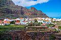 Agulo 2017
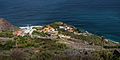 Lepe, Agulo 2017
 Agulo
Agulo


See also
- List of municipalities in Santa Cruz de Tenerife
References
- "SUPERFICIE, PERÍMETRO Y ALTITUD DE LOS MUNICIPIOS DE CANARIAS" (in Spanish). Instituto Canario de Estadística (ISTAC).[permanent dead link]
- Municipal Register of Spain 2018. National Statistics Institute.
- "Población en Canarias. La Gomera. 1-1-2013" (in Spanish). Instituto Canario de Estadística (ISTAC). Archived from the original on 2014-04-19.
Further reading
- Brown, A. Samler. Madeira, Canary Islands and Azores. (London, S.E.: Sampson Low, Marston & Co., Limited, 1908).
External links
| Wikimedia Commons has media related to Agulo. |
Municipalities in the province of Santa Cruz de Tenerife | ||
|---|---|---|
| Tenerife |
| |
| La Palma |
| |
| La Gomera |
| |
| El Hierro |
| |
| Authority control |
|
|---|
На других языках
- [en] Agulo
[es] Agulo
Agulo es un municipio español perteneciente a la isla de La Gomera, en la provincia de Santa Cruz de Tenerife, comunidad autónoma de Canarias. Se encuentra situado al norte de la misma, entre los valles y municipios de Hermigua y Vallehermoso, siendo con sus 25.39 km² de superficie el término municipal más pequeño de la isla. Con una población de 1096 habitantes (ISTAC, 2019) es el municipio menos poblado de las cuatro islas que conforman la provincia.[ru] Агуло
Агуло (исп. Agulo) — муниципалитет в Испании, входит в провинцию Санта-Крус-де-Тенерифе в составе автономного сообщества Канарские острова. Находится на острове Гомера. Занимает площадь 25,39 км². Население 1110 человек (на 2020 год).Текст в блоке "Читать" взят с сайта "Википедия" и доступен по лицензии Creative Commons Attribution-ShareAlike; в отдельных случаях могут действовать дополнительные условия.
Другой контент может иметь иную лицензию. Перед использованием материалов сайта WikiSort.org внимательно изучите правила лицензирования конкретных элементов наполнения сайта.
Другой контент может иметь иную лицензию. Перед использованием материалов сайта WikiSort.org внимательно изучите правила лицензирования конкретных элементов наполнения сайта.
2019-2026
WikiSort.org - проект по пересортировке и дополнению контента Википедии
WikiSort.org - проект по пересортировке и дополнению контента Википедии