world.wikisort.org - Spain
Humanes de Madrid is a town and municipality of Spain, part of the Community of Madrid.[2] As of 2019, it has a population of 19,743 inhabitants.[2]
Humanes de Madrid | |
|---|---|
Municipality | |
 | |
 Flag  Coat of arms | |
 Humanes de Madrid 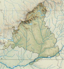 Humanes de Madrid | |
| Coordinates: 40°15′14″N 3°49′40″W | |
| Country | Spain |
| Autonomous community | Community of Madrid |
| Government | |
| • Alcalde | José Antonio Sánchez Rodríguez (PP) |
| Area | |
| • Total | 19.46 km2 (7.51 sq mi) |
| Elevation | 677 m (2,221 ft) |
| Population (2018)[1] | |
| • Total | 19,587 |
| • Density | 1,000/km2 (2,600/sq mi) |
| Demonym(s) | Humanenses |
| Time zone | UTC+1 (CET) |
| • Summer (DST) | UTC+2 (CEST) |
| Postal code | 28970 |
| Dialing code | (+34) 91 |
| Website | Official website |
Geography

The municipality, with a total area of 1946 km2,[2] features a largely flat relief, with the altitude ranging from the roughly 700 metres above sea level of the Cerro del Lomo to the roughly 644 metres of the Arroyo de las Arroyadas close to its confluence with the Arroyo de Valdenovillo del Prado,[3] at the southeastern end of the municipality.
History
Humanes is first mentioned in a 1141 document, when Alfonso VII donated the town to its first Lord.[4] Humanes belonged to the Land of Toledo for the entire early modern period.[5]
References
- Citations
- Municipal Register of Spain 2018. National Statistics Institute.
- "Datos del registro de entidades locales". Ministerio de Hacienda y Administraciones Públicas. Retrieved 27 March 2020.
- Lorenzo Nieto 2004, p. 21.
- Lorenzo Nieto 2004, p. 22.
- Lorenzo Nieto 2004, p. 24.
- Bibliography
- Lorenzo Nieto, Pilar (2004). "Humanes de Madrid". Arquitectura y desarrollo humano. Comunidad de Madrid (PDF). Vol. XII. Madrid: Dirección General de Arquitectura y Vivienda & Colegio Oficial de Arquitectos de Madrid. pp. 17–47. ISBN 84-451-2698-9.
External links
- The official site of the city (in Spanish)
This article about a location in the Community of Madrid, Spain is a stub. You can help Wikipedia by expanding it. |
Municipalities of the Community of Madrid | ||
|---|---|---|
| 3,000,000+ |
| |
| 200,000+ |
| |
| 150,000+ |
| |
| 100,000+ |
| |
| 50,000+ |
| |
| 25,000+ |
| |
| under 25,000 |
| |
Authority control | |
|---|---|
| General |
|
| Other |
|
На других языках
- [en] Humanes de Madrid
[es] Humanes de Madrid
Humanes de Madrid es un municipio y localidad de España, en la comunidad autónoma de Madrid.[ru] Уманес-де-Мадрид
Уманес-де-Мадрид (исп. Humanes de Madrid) — населённый пункт и муниципалитет в Испании, входит в провинцию Мадрид в составе автономного сообщества Мадрид. Муниципалитет находится в составе района (комарки) Комарка-Сур. Занимает площадь 20 км². Население — 18541 человек (на 2010 год). Расстояние до административного центра провинции — 23 км.Другой контент может иметь иную лицензию. Перед использованием материалов сайта WikiSort.org внимательно изучите правила лицензирования конкретных элементов наполнения сайта.
WikiSort.org - проект по пересортировке и дополнению контента Википедии