world.wikisort.org - Spain
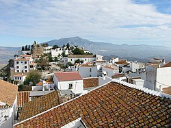
Comares is a town and municipality in the province of Málaga, part of the autonomous community of Andalusia in southern Spain. The municipality is situated approximately 28 kilometers from the provincial capital and 24 from Vélez-Málaga. It is located in the foothills of the Montes de Málaga 703 meters above sea level. Comares is one of the 31 villages that make up the comarca of Axarquía.
Comares | |
|---|---|
 | |
 Seal | |
 Comares Location in Andalusia | |
| Coordinates: 36°51′N 4°14′W | |
| Sovereign state | |
| Autonomous community | |
| Province | |
| Comarca | Axarquía |
| Government | |
| Area | |
| • Total | 25.5 km2 (9.8 sq mi) |
| Elevation | 703 m (2,306 ft) |
| Population (2018)[1] | |
| • Total | 1,323 |
| • Density | 52/km2 (130/sq mi) |
| Demonym | Comareño |
| Time zone | UTC+1 (CET) |
| • Summer (DST) | UTC+2 (CEST) |
| Postal code | 29195 |
| Website | http://www.comares.es |
 | |
It is bordered to the north with Riogordo, to the north, northeast and east with Cútar, to the south with El Borge, to the southwest and west with Málaga and to the northwest with Colmenar.
It has a population of approximately 1,420 residents. The natives are called Moriscosos.
Geography
The population core is located in slight decline, on the crest of a steep mountain at 703 m. The region is full of ravines, hamlets and farms scattered around the mountain. Its highest point is the hill of Mazmúllar (721 m). A dip the end of the rivers Cuevas or Benamargosa feeds the streams of Cútar, Fuente Delgada and Solano, which are dry most of the year.[citation needed] The town's water supply comes from the springs called Délga, Gorda, Caño Seco and Maroto.
The main economic activity is agriculture, such as olives, grapes and almonds. Comares is on the Ruta de la Pasa, the route of the grape. The Pasas de Málaga are a Protected Designation of Origin. These grapes are only grown in the Axarquía and around Manilva.[2] The grapes are dried in the sun in typical drying cages called paseros. In recent years rural tourism has become a major part of the economy of Comares.
History
The origin of the name Comares is from the Arabic word Qumaris or Hins Comarix, which means "Castle in the height." Comares was not founded by the Arabs, but by the Greeks and Phoenicians who arrived on the coast of Málaga in the seventh century BC. It was a Moorish fortress since the eighth century CE We also know that was one of the defensive bastions of Omar ben Hafsun in his fight against the Umayyad Caliphate of Córdoba. It was considered one of the strategic points of the Rayya (Archidona), then capital of the taha of Malaga.
References
- Municipal Register of Spain 2018. National Statistics Institute.
- "D.O. Pasas de Málaga – Consejo Regulador" (in Spanish). Retrieved 2019-07-28.

На других языках
[de] Comares
Comares ist eine spanische Gemeinde in Andalusien in der Provinz Málaga. Sie befindet sich 39 Kilometer nordöstlich von Málaga auf 703 Meter Höhe in der Axarquía, dem östlichsten Teil der Provinz Málaga. Comares ist ein typisches weißes Dorf mit prärömischer Geschichte. Die maurische Epoche von Comares endete im Jahr 1487, als das Dorf, das damals aufgrund seines strategischen Standortes wichtiger Verteidigungspunkt war, an die Christen fiel. Comares thront auf einem Felssporn und bietet Rundumausblicke bis zur Küste. Neben einer Pfarrkirche gibt es eine restaurierte Olivenmühle (heute ein Hotel) und ein Kastell. Kulturell ist Comares bekannt für die Pflege der Verdiales, einer frühen Flamenco-Form, die mit Gitarren, Geige, Tamburin, Tänzern und Sängern zu den Fiestas zelebriert wird.- [en] Comares
[es] Comares
Comares es un municipio español de la provincia de Málaga, Andalucía, con el título de Marquesado, situado en las estribaciones de los Montes de Málaga a 703 metros sobre el nivel del mar. Comares es uno de los 31 pueblos que conforman la comarca de la Axarquía. Conocido como el "Balcón de la Axarquía".[ru] Комарес
Комарес (исп. Comares) — муниципалитет в Испании, входит в провинцию Малага, в составе автономного сообщества Андалусия. Муниципалитет находится в составе района (комарки) Аксаркия-Коста-дель-Соль. Занимает площадь 25 км². Население — 1615 человек (на 2010 год). Расстояние — 39 км до административного центра провинции.Другой контент может иметь иную лицензию. Перед использованием материалов сайта WikiSort.org внимательно изучите правила лицензирования конкретных элементов наполнения сайта.
WikiSort.org - проект по пересортировке и дополнению контента Википедии
