world.wikisort.org - Spain
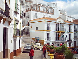
Almogía is a town and municipality in the province of Málaga, part of the autonomous community of Andalusia in southern Spain. It is situated approximately 25 km from the city of Málaga, has a population of approximately 4,300 residents and has an economy based on the cultivation of almonds and olives. Positioned within the Montes de Málaga hills, the municipality's highest point is Santi Petri (794 m).[2] The district's main watercourses are the River Campanillas and the Arroyos de Cauche and de los Olivos.
Almogía | |
|---|---|
Municipality | |
 | |
 Coat of arms | |
 Municipal location in the Province of Málaga | |
 Almogía Location in Spain | |
| Coordinates: 36°49′36″N 4°32′12″W | |
| Sovereign state | |
| Autonomous community | |
| Province | |
| Comarca | Málaga-Costa del Sol |
| Government | |
| • Mayor | Cristóbal Torreblanca Sánchez (PSOE) |
| Area | |
| • Total | 164 km2 (63 sq mi) |
| Elevation | 357 m (1,171 ft) |
| Population (2018)[1] | |
| • Total | 3,770 |
| • Density | 23/km2 (60/sq mi) |
| Demonym | Almogiense |
| Time zone | UTC+1 (CET) |
| • Summer (DST) | UTC+2 (CEST) |
| Postal code | 29150 |
| Website | www.almogia.es |
References
- Municipal Register of Spain 2018. National Statistics Institute.
- "Almogía". Andalucia.cc. Retrieved 10 September 2014.
External links
Wikimedia Commons has media related to Almogía.
- Official site (in Spanish)
На других языках
[de] Almogía
Almogía ist eine Gemeinde (municipio) mit 3.715 Einwohnern (Stand: 1. Januar 2019) in der Provinz Málaga in der Autonomen Region Andalusien im Süden Spaniens.- [en] Almogía
[es] Almogía
Almogía es una villa y municipio español de la provincia de Málaga, Andalucía, situada en las estribaciones de los Montes de Málaga. Limita al norte con la villa y municipio de Antequera y con el de Villanueva de la Concepción, al este con Casabermeja y Málaga, al sur con los municipios de Málaga y Cártama, y al oeste con el municipio de Álora.[ru] Альмохия
Альмохия (исп. Almogía) — муниципалитет в Испании, входит в провинцию Малага, в составе автономного сообщества Андалусия. Муниципалитет находится в составе района (комарки) Малага — Коста-дель-Соль. Занимает площадь 164 км². Население — 4257 человек (на 2010 год). Расстояние — 23 км до административного центра провинции.Текст в блоке "Читать" взят с сайта "Википедия" и доступен по лицензии Creative Commons Attribution-ShareAlike; в отдельных случаях могут действовать дополнительные условия.
Другой контент может иметь иную лицензию. Перед использованием материалов сайта WikiSort.org внимательно изучите правила лицензирования конкретных элементов наполнения сайта.
Другой контент может иметь иную лицензию. Перед использованием материалов сайта WikiSort.org внимательно изучите правила лицензирования конкретных элементов наполнения сайта.
2019-2025
WikiSort.org - проект по пересортировке и дополнению контента Википедии
WikiSort.org - проект по пересортировке и дополнению контента Википедии