world.wikisort.org - South_Korea
Uljin County (Uljin-gun; Korean: 울진군) is a county in North Gyeongsang Province, South Korea. Before 1963, Uljin was in Gangwon Province.
Uljin
울진군 | |
|---|---|
County | |
| Korean transcription(s) | |
| • Hangul | 울진군 |
| • Hanja | 蔚珍郡 |
| • Revised Romanization | Uljin-gun |
| • McCune-Reischauer | Ulchin-gun |
 Flag Emblem of Uljin | |
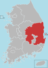
 Location in South Korea | |
| Country | |
| Region | Yeongnam Gwandong (before 1963) |
| Administrative divisions | 2 eup, 8 myeon |
| Government | |
| • Type | Uljin County |
| • Mayor | Im Kwang-Won |
| Area | |
| • Total | 989.06 km2 (381.88 sq mi) |
| Population (5/06/2010) | |
| • Total | 52,385 |
| • Density | 61.7/km2 (160/sq mi) |
| • Dialect | Gyeongsang Gangwon |
It borders the Sea of Japan in the east, Bonghwa-gun and Yeongyang-gun in the west, Yeongdeok-gun in the south, and Samcheok-si, Gangwon-do in the north. It is located at 129°04'∼129°29' east longitude and 36°38'∼37°06' north latitude. The area is 989.43 square kilometers, and the population is 51,885 (as of 2015). There are 2 eups, 8 myeons, and 195 administrative districts (79 Beopjeong-ri). The county office is located in Eupnae-ri, Uljin-eup, Uljin-gun, Gyeongsangbuk-do.
Administrative divisions
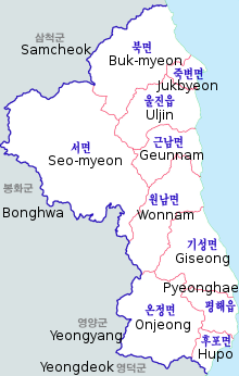
Uljin County is divided into 2 eup and 8 myeon.
| Name | Hangeul | Hanja |
|---|---|---|
| Uljin-eup | 울진읍 | 蔚珍邑 |
| Pyeonghae-eup | 평해읍 | 平海邑 |
| Buk-myeon | 북면 | 北面 |
| Geumgangsong-myeon | 금강송면 | 金剛松面 |
| Geunnam-myeon | 근남면 | 近南面 |
| Maehwa-myeon | 매화면 | 梅花面 |
| Giseong-myeon | 기성면 | 箕城面 |
| Onjeong-myeon | 온정면 | 溫井面 |
| Jukbyeon-myeon | 죽변면 | 竹邊面 |
| Hupo-myeon | 후포면 | 厚浦面 |
Culture and sightseeing
Festivals
Uljin's festivals reflect the county's agricultural and maritime industry.
In 2005 and 2009 for three weeks, Uljin hosted the Uljin Organic Food Exhibition (울진세계친환경농업엑스포) in Uljin's Expo Park. The expo features global representatives of the organic food industry, interactive activities, live music, and food. The next expo is slated for July 2013.
- Uljin Snow Crab Promotion Exhibition Center
Museums
- Freshwater Fish Museum
- Hupo-ri Neolithic Historic Museum
- Wonjaryeok Museum
- Hyangam Museum of Art
- Bongpyeong Silla Stele in Uljin
Parks
- Gusugok Recreational Forest
- Nagok ocean fishing park
- Expo Park
- Tonggosan Recreational Forest
- Geumgang Pine Forest of Uljin
Villages
- Giseongri Fishing and Recreation Village
- Nagok1ri Fishing and Recreation Village
- Ssangjeolli Green Village
- Wangpi Georigo Village
Experiences
- Geoil 1ri Fishing Village Experiences
- Deokgu Spa
- Sung Ryu Park Hot Spring
- Uljin Science Experience
- 'Into The Storm' Drama Set
- Baegam Hot Springs Special Tourist Zone
- Geumgangsong Ecorium
- Uljin Guemgangsong Culture Center
- Hanhwa Condominium
- Camphorse
- Ul-Jin Yacht School
- Ul-jin Ocean Leports Center
Other important spots
- Seongnyugul Cave
- Sinsun Valley
Architecture
Historical
- Buryeongsa Temple
- Mangyangjeong Pavilion
- Wolsongjeong Pavilion
Modern
- Deunggisan Suspension Bridge
Economy
The Uljin Nuclear Power Plant, one of four nuclear power plants in South Korea, is located in Bugu. The plant currently has six reactors and is a top source of jobs for the county and region.[1]
Education
High schools
- Hupo High School
- Jukbyeon High School
- Pyeonghae Gongeob High School
- Pyeonghae Jeongbo High School
- Uljin High School
Middle schools
- Bugu Middle School
- Giseong Middle School
- Hupo Middle School
- Jukbyeon Middle School
- Maewha Middle School
- Onjeong Middle School
- Pyeonghae Middle School
- Pyeonghae Girl's Middle School
- Uljin Middle School
Elementary schools
- Bugu Elementary School
- Giseong Elementary School
- Hupo Elementary School
- Hupo Dongbu Elementary School
- Jukbyeon Elementary School
- Maewha Elementary School
- Noeum Elementary School
- Onjeong Elementary School
- Pyeonghae Elementary School
- Uljin Elementary School
- Uljin Nambu Elementary School
- Sadong Elementary School
- Samgeun Elementary School
- Wolsong Elementary School
Climate
| Climate data for Uljin (1991–2020 normals, extremes 1971–present) | |||||||||||||
|---|---|---|---|---|---|---|---|---|---|---|---|---|---|
| Month | Jan | Feb | Mar | Apr | May | Jun | Jul | Aug | Sep | Oct | Nov | Dec | Year |
| Record high °C (°F) | 17.4 (63.3) |
24.0 (75.2) |
27.7 (81.9) |
33.7 (92.7) |
35.6 (96.1) |
36.0 (96.8) |
37.1 (98.8) |
37.8 (100.0) |
35.4 (95.7) |
29.7 (85.5) |
27.2 (81.0) |
21.4 (70.5) |
37.8 (100.0) |
| Average high °C (°F) | 6.5 (43.7) |
7.9 (46.2) |
11.8 (53.2) |
17.2 (63.0) |
21.1 (70.0) |
23.3 (73.9) |
26.8 (80.2) |
27.5 (81.5) |
24.1 (75.4) |
20.1 (68.2) |
14.5 (58.1) |
8.9 (48.0) |
17.5 (63.5) |
| Daily mean °C (°F) | 1.4 (34.5) |
3.0 (37.4) |
6.9 (44.4) |
12.1 (53.8) |
16.3 (61.3) |
19.4 (66.9) |
23.1 (73.6) |
23.9 (75.0) |
20.0 (68.0) |
15.1 (59.2) |
9.3 (48.7) |
3.6 (38.5) |
12.8 (55.0) |
| Average low °C (°F) | −2.9 (26.8) |
−1.6 (29.1) |
2.1 (35.8) |
7.1 (44.8) |
11.8 (53.2) |
16.0 (60.8) |
20.3 (68.5) |
21.1 (70.0) |
16.3 (61.3) |
10.4 (50.7) |
4.4 (39.9) |
−1.0 (30.2) |
8.7 (47.7) |
| Record low °C (°F) | −16.1 (3.0) |
−14.1 (6.6) |
−10.2 (13.6) |
−3.0 (26.6) |
2.8 (37.0) |
6.5 (43.7) |
11.9 (53.4) |
11.3 (52.3) |
7.3 (45.1) |
−0.8 (30.6) |
−6.5 (20.3) |
−13.8 (7.2) |
−16.1 (3.0) |
| Average precipitation mm (inches) | 48.9 (1.93) |
36.9 (1.45) |
56.0 (2.20) |
76.4 (3.01) |
70.5 (2.78) |
104.3 (4.11) |
203.0 (7.99) |
213.0 (8.39) |
181.2 (7.13) |
97.3 (3.83) |
61.0 (2.40) |
33.2 (1.31) |
1,181.7 (46.52) |
| Average precipitation days (≥ 0.1 mm) | 5.6 | 5.9 | 8.2 | 7.8 | 8.0 | 9.4 | 13.9 | 13.9 | 11.6 | 6.7 | 6.7 | 4.5 | 102.2 |
| Average snowy days | 3.3 | 3.3 | 2.7 | 0.1 | 0.0 | 0.0 | 0.0 | 0.0 | 0.0 | 0.0 | 0.3 | 1.6 | 11.3 |
| Average relative humidity (%) | 50.2 | 54.6 | 60.0 | 62.7 | 70.5 | 80.4 | 83.6 | 84.0 | 80.4 | 69.7 | 60.1 | 50.1 | 67.2 |
| Mean monthly sunshine hours | 200.8 | 189.4 | 209.6 | 223.9 | 232.5 | 196.9 | 166.6 | 175.8 | 171.4 | 198.8 | 183.6 | 201.6 | 2,350.9 |
| Percent possible sunshine | 65.9 | 61.1 | 55.5 | 58.1 | 53.8 | 44.2 | 36.5 | 44.0 | 46.9 | 58.4 | 61.4 | 68.0 | 53.3 |
| Source: Korea Meteorological Administration (snow and percent sunshine 1981–2010)[2][3][4][5][6] | |||||||||||||
Sister cities
 Goyang, South Korea
- Yangcheon-gu, South Korea
- Seocho-gu, South Korea
- Suseong-gu, South Korea
- Dong-gu, Busan, South Korea
 Omaezaki, Shizuoka Prefecture, Japan[7]
References
- "::: KOREA NUCLEAR ENERGY FOUNDATION :::". Archived from the original on 2007-06-22.
- "Climatological Normals of Korea (1991 ~ 2020)" (PDF) (in Korean). Korea Meteorological Administration. Archived from the original (PDF) on 29 January 2022. Retrieved 4 April 2022.
- 우리나라 기후평년값 - 파일셋 (in Korean). Korea Meteorological Administration. Retrieved 4 April 2022.
- 우리나라 기후평년값 - 그래프 (in Korean). Korea Meteorological Administration. Retrieved 4 April 2022.
- 순위값 - 구역별조회 (in Korean). Korea Meteorological Administration. Retrieved 4 April 2022.
- "Climatological Normals of Korea" (PDF). Korea Meteorological Administration. 2011. Archived from the original (PDF) on 7 December 2016. Retrieved 8 December 2016.
- "International Exchange". List of Affiliation Partners within Prefectures. Council of Local Authorities for International Relations (CLAIR). Archived from the original on 24 December 2015. Retrieved 21 November 2015.
External links
Authority control | |
|---|---|
| General |
|
| National libraries | |
На других языках
- [en] Uljin County
[ru] Ульджин
Ульджи́н (кор. 울진군?, 蔚珍郡?, Ульчин-гун) — уезд в провинции Кёнсан-Пукто, Южная Корея.Другой контент может иметь иную лицензию. Перед использованием материалов сайта WikiSort.org внимательно изучите правила лицензирования конкретных элементов наполнения сайта.
WikiSort.org - проект по пересортировке и дополнению контента Википедии