world.wikisort.org - South_Africa
Ga-Lamola (sometimes called Rozenkrantz) is a sparsely populated village in Ga-Matlala in the Blouberg Local Municipality of the Capricorn District Municipality of the Limpopo province of South Africa. It is located 73 km northwest of Polokwane and 32 km southeast of Senwabarwana.
Ga-Lamola | |
|---|---|
 Ga-Lamola  Ga-Lamola | |
| Coordinates: 23.495°S 28.996°E | |
| Country | South Africa |
| Province | Limpopo |
| District | Capricorn |
| Municipality | Blouberg |
| Area | |
| • Total | 2.73 km2 (1.05 sq mi) |
| Elevation | 1,086 m (3,563 ft) |
| Population (2011)[1] | |
| • Total | 533 |
| • Density | 200/km2 (510/sq mi) |
| Racial makeup (2011) | |
| • Black African | 100.0% |
| First languages (2011) | |
| • Northern Sotho | 96.8% |
| • Other | 3.2% |
| Time zone | UTC+2 (SAST) |
| Postal code (street) | 0748 |
| Area code | +27 (0)15 |
Education
Health
- Rozenkrantz Clinic.[4]
Sports
Football is the most popular sport in Ga-Lamola.
- Selata F.C.
- Ditlou F.C.
References
Municipalities and communities of Capricorn District Municipality, Limpopo | ||
|---|---|---|
District seat: Polokwane | ||
| Blouberg | 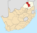 | |
| Molemole | ||
| Polokwane |
| |
| Lepelle-Nkumpi | ||
Текст в блоке "Читать" взят с сайта "Википедия" и доступен по лицензии Creative Commons Attribution-ShareAlike; в отдельных случаях могут действовать дополнительные условия.
Другой контент может иметь иную лицензию. Перед использованием материалов сайта WikiSort.org внимательно изучите правила лицензирования конкретных элементов наполнения сайта.
Другой контент может иметь иную лицензию. Перед использованием материалов сайта WikiSort.org внимательно изучите правила лицензирования конкретных элементов наполнения сайта.
2019-2025
WikiSort.org - проект по пересортировке и дополнению контента Википедии
WikiSort.org - проект по пересортировке и дополнению контента Википедии