world.wikisort.org - South_Africa
Canzibe is a village of 1,000 inhabitants in the Eastern Cape province of South Africa. It is situated near the R61 road from Port St. Johns to Mthatha in the Nyandeni Local Municipality, which is part of the OR Tambo District Municipality. As a small village it features some primary schools and a hospital, the Canzibe Hospital.[2]
Canzibe | |
|---|---|
 Canzibe  Canzibe | |
| Coordinates: 31°48′30″S 29°04′00″E | |
| Country | South Africa |
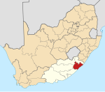
| Province | Eastern Cape |
| District | O.R.Tambo |
| Municipality | Nyandeni |
| Area | |
| • Total | 1.29 km2 (0.50 sq mi) |
| Population (2011)[1] | |
| • Total | 1,005 |
| • Density | 780/km2 (2,000/sq mi) |
| Racial makeup (2011) | |
| • Black African | 99.0% |
| • Coloured | 0.2% |
| • Indian/Asian | 0.1% |
| • White | 0.5% |
| • Other | 0.2% |
| First languages (2011) | |
| • Xhosa | 93.5% |
| • English | 1.9% |
| • Zulu | 1.7% |
| • Other | 2.9% |
| Time zone | UTC+2 (SAST) |
| Postal code (street) | 5144 |
| PO box | 5144 |
| Area code | 047 |
Economy
Canzibe is part of one of the poorest areas of South Africa. Unemployment in 2008 was at 92%.[3]
Tourism
Near Canzibe is the Hluleka Nature Reserve and Hluleka Beach (24 km away), as well as Presely Bay (18 km).[4]
References
- "Main Place Canzibe". Census 2011.
- Eastern Cape Dept of Health official website
- W.K. Kellogg Foundation Archived 2012-03-28 at the Wayback Machine
- Nyandeni Local Municipality
Municipalities and communities of OR Tambo District Municipality, Eastern Cape | ||
|---|---|---|
District seat: Mthatha | ||
| Ingquza Hill |
|  |
| Port St Johns |
| |
| Nyandeni |
| |
| Mhlontlo | ||
| King Sabata Dalindyebo | ||
Текст в блоке "Читать" взят с сайта "Википедия" и доступен по лицензии Creative Commons Attribution-ShareAlike; в отдельных случаях могут действовать дополнительные условия.
Другой контент может иметь иную лицензию. Перед использованием материалов сайта WikiSort.org внимательно изучите правила лицензирования конкретных элементов наполнения сайта.
Другой контент может иметь иную лицензию. Перед использованием материалов сайта WikiSort.org внимательно изучите правила лицензирования конкретных элементов наполнения сайта.
2019-2025
WikiSort.org - проект по пересортировке и дополнению контента Википедии
WikiSort.org - проект по пересортировке и дополнению контента Википедии