world.wikisort.org - South_Africa
Ngqeleni is a town in O.R.Tambo District Municipality in the Eastern Cape province of South Africa.
Ngqeleni | |
|---|---|
 Ngqeleni  Ngqeleni | |
| Coordinates: 31.670°S 29.028°E | |
| Country | South Africa |
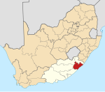
| Province | Eastern Cape |
| District | O.R.Tambo |
| Municipality | Nyandeni |
| Area | |
| • Total | 2.28 km2 (0.88 sq mi) |
| Population (2011)[1] | |
| • Total | 2,629 |
| • Density | 1,200/km2 (3,000/sq mi) |
| Racial makeup (2011) | |
| • Black African | 97.2% |
| • Coloured | 1.6% |
| • Indian/Asian | 0.3% |
| • White | 0.3% |
| • Other | 0.5% |
| First languages (2011) | |
| • Xhosa | 87.4% |
| • English | 7.0% |
| • Sign language | 1.6% |
| • Northern Sotho | 1.1% |
| • Other | 3.0% |
| Time zone | UTC+2 (SAST) |
| Postal code (street) | 5140 |
| PO box | 5140 |
| Area code | 047 |
Village in West Pondoland, 32 km southeast of Umtata and about 40 km north-north-west of Coffee Bay. The name is derived from the Xhosa ngqele, ‘cold’ or ‘frost’. Coldstream, which flows past it, may have a name translated from Ngqeleni, ‘at the cold’."[2]
References
- "Main Place Ngqeleni". Census 2011.
- "Dictionary of Southern African Place Names (Public Domain)". Human Science Research Council. p. 335.
Municipalities and communities of OR Tambo District Municipality, Eastern Cape | ||
|---|---|---|
District seat: Mthatha | ||
| Ingquza Hill |
|  |
| Port St Johns |
| |
| Nyandeni |
| |
| Mhlontlo |
| |
| King Sabata Dalindyebo |
| |
This Eastern Cape location article is a stub. You can help Wikipedia by expanding it. |
Текст в блоке "Читать" взят с сайта "Википедия" и доступен по лицензии Creative Commons Attribution-ShareAlike; в отдельных случаях могут действовать дополнительные условия.
Другой контент может иметь иную лицензию. Перед использованием материалов сайта WikiSort.org внимательно изучите правила лицензирования конкретных элементов наполнения сайта.
Другой контент может иметь иную лицензию. Перед использованием материалов сайта WikiSort.org внимательно изучите правила лицензирования конкретных элементов наполнения сайта.
2019-2025
WikiSort.org - проект по пересортировке и дополнению контента Википедии
WikiSort.org - проект по пересортировке и дополнению контента Википедии