world.wikisort.org - South_Africa
Buntingville is a Methodist mission station 15 km south-east of Mthatha. Originally established by the Reverend W B Boyce in 1830 as Old Bunting near the village of the Pondo chief Faku at the headwaters of the Umngazana River, it was transferred about 1865. Named after Jabez Bunting (1779–1858), the English Wesleyan church leader.[2]
Buntingville | |
|---|---|
 Buntingville  Buntingville | |
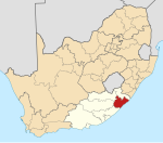
| Coordinates: 31.639°S 28.869°E | |
| Country | South Africa |
| Province | Eastern Cape |
| District | OR Tambo |
| Municipality | Nyandeni |
| Government | |
| • Councillor | Mbumbulwana |
| Area | |
| • Total | 3.44 km2 (1.33 sq mi) |
| Population (2011)[1] | |
| • Total | 1,090 |
| • Density | 320/km2 (820/sq mi) |
| Racial makeup (2011) | |
| • Black African | 99.8% |
| • Coloured | 0.1% |
| • Other | 0.1% |
| First languages (2011) | |
| • Xhosa | 98.3% |
| • Other | 1.7% |
| Time zone | UTC+2 (SAST) |
| PO box | 5115 |
References
- "Main Place Buntingville". Census 2011.
- Raper, Peter E. (1987). Dictionary of Southern African Place Names. Internet Archive. p. 99. Retrieved 28 August 2013.
Municipalities and communities of OR Tambo District Municipality, Eastern Cape | ||
|---|---|---|
District seat: Mthatha | ||
| Ingquza Hill |
|  |
| Port St Johns |
| |
| Nyandeni |
| |
| Mhlontlo | ||
| King Sabata Dalindyebo | ||
Текст в блоке "Читать" взят с сайта "Википедия" и доступен по лицензии Creative Commons Attribution-ShareAlike; в отдельных случаях могут действовать дополнительные условия.
Другой контент может иметь иную лицензию. Перед использованием материалов сайта WikiSort.org внимательно изучите правила лицензирования конкретных элементов наполнения сайта.
Другой контент может иметь иную лицензию. Перед использованием материалов сайта WikiSort.org внимательно изучите правила лицензирования конкретных элементов наполнения сайта.
2019-2025
WikiSort.org - проект по пересортировке и дополнению контента Википедии
WikiSort.org - проект по пересортировке и дополнению контента Википедии