world.wikisort.org - South_Africa
aMatikulu is a settlement in Uthungulu District Municipality in the KwaZulu-Natal province of South Africa.
aMatikulu | |
|---|---|
 aMatikulu  aMatikulu | |
| Coordinates: 29.05°S 31.533333°E | |
| Country | South Africa |
| Province | KwaZulu-Natal |
| District | Uthungulu |
| Municipality | uMlalazi |
| Area | |
| • Total | 1.39 km2 (0.54 sq mi) |
| Population (2011)[1] | |
| • Total | 515 |
| • Density | 370/km2 (960/sq mi) |
| Racial makeup (2011) | |
| • Black African | 74.0% |
| • Coloured | 3.3% |
| • Indian/Asian | 16.9% |
| • White | 5.4% |
| • Other | 0.4% |
| First languages (2011) | |
| • Zulu | 59.8% |
| • English | 26.1% |
| • Afrikaans | 5.7% |
| • S. Ndebele | 4.7% |
| • Other | 3.7% |
| Time zone | UTC+2 (SAST) |

Town some 130 km north-east of Durban, near Gingindlovu. Named after the Matigulu, also spelt Amatikulu, River. From Lala or Zulu, probably "large water", i.e. "large river". The approved form is aMatikulu.[2]
References
- "Main Place aMatikulu". Census 2011.
- "Dictionary of Southern African Place Names (Public Domain)". Human Science Research Council. p. 299.
Municipalities and communities of King Cetshwayo District Municipality, KwaZulu-Natal | ||
|---|---|---|
District seat: Richards Bay | ||
| uMhlathuze | 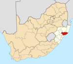 | |
| uMlalazi | ||
| Nkandla | ||
| Mbonambi |
| |
| Ntambanana | ||
| Mthonjaneni | ||
This KwaZulu-Natal location article is a stub. You can help Wikipedia by expanding it. |
Текст в блоке "Читать" взят с сайта "Википедия" и доступен по лицензии Creative Commons Attribution-ShareAlike; в отдельных случаях могут действовать дополнительные условия.
Другой контент может иметь иную лицензию. Перед использованием материалов сайта WikiSort.org внимательно изучите правила лицензирования конкретных элементов наполнения сайта.
Другой контент может иметь иную лицензию. Перед использованием материалов сайта WikiSort.org внимательно изучите правила лицензирования конкретных элементов наполнения сайта.
2019-2025
WikiSort.org - проект по пересортировке и дополнению контента Википедии
WikiSort.org - проект по пересортировке и дополнению контента Википедии