world.wikisort.org - South_Africa
Gingindlovu is a town in Uthungulu District Municipality in the KwaZulu-Natal province of South Africa.
Gingindlovu | |
|---|---|
 Gingindlovu  Gingindlovu | |
| Coordinates: 29°1′S 31°35′E | |
| Country | South Africa |
| Province | KwaZulu-Natal |
| District | King Cetshwayo |
| Municipality | uMlalazi |
| Area | |
| • Total | 2.39 km2 (0.92 sq mi) |
| Population (2011)[1] | |
| • Total | 1,109 |
| • Density | 460/km2 (1,200/sq mi) |
| Racial makeup (2011) | |
| • Black African | 57.6% |
| • Coloured | 11.3% |
| • Indian/Asian | 29.2% |
| • White | 1.1% |
| • Other | 0.8% |
| First languages (2011) | |
| • Zulu | 49.1% |
| • English | 44.8% |
| • Afrikaans | 1.6% |
| • S. Ndebele | 1.2% |
| • Other | 3.3% |
| Time zone | UTC+2 (SAST) |
| Postal code (street) | 3800 |
| PO box | 3800 |
| Area code | 035 |
Village 21 km south-east of Eshowe. The name was first applied to one of Cetshwayo's military kraals nearby. Of Zulu origin, it is said to mean 'place of the big elephant' or, more possibly, 'swallower of the elephant', referring to Cetshwayo's victory over his brother Mbulazi in 1856.[2]
References
- "Main Place Gingindlovu". Census 2011.
- "Dictionary of Southern African Place Names (Public Domain)". Human Science Research Council. p. 177.
Municipalities and communities of King Cetshwayo District Municipality, KwaZulu-Natal | ||
|---|---|---|
District seat: Richards Bay | ||
| uMhlathuze | 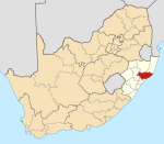 | |
| uMlalazi |
| |
| Nkandla | ||
| Mbonambi |
| |
| Ntambanana | ||
| Mthonjaneni | ||
This KwaZulu-Natal location article is a stub. You can help Wikipedia by expanding it. |
На других языках
[de] KwaGingindlovu
KwaGingindlovu (bis 2009 Gingindlovu)[1] ist eine Stadt in der südafrikanischen Provinz KwaZulu-Natal. Sie befindet sich in der Gemeinde uMlalazi im Distrikt King Cetshwayo. 2011 hatte sie 1109 Einwohner.[2] Der Name des Orts ist der isiZulu-Begriff für „Ort des Elefantenschluckers“. Hier hatte der Zulukönig Cetshwayo seinen Bruder Mbulazi im Kampf um den Thron besiegt. Anschließend baute Cetshwayo hier ein Kraal auf,[3] das er als Militärbasis benutzte.[4] Heute ist KwaGingindlovu ein Zentrum für den Zuckerrohranbau.[5]- [en] Gingindlovu
Текст в блоке "Читать" взят с сайта "Википедия" и доступен по лицензии Creative Commons Attribution-ShareAlike; в отдельных случаях могут действовать дополнительные условия.
Другой контент может иметь иную лицензию. Перед использованием материалов сайта WikiSort.org внимательно изучите правила лицензирования конкретных элементов наполнения сайта.
Другой контент может иметь иную лицензию. Перед использованием материалов сайта WikiSort.org внимательно изучите правила лицензирования конкретных элементов наполнения сайта.
2019-2025
WikiSort.org - проект по пересортировке и дополнению контента Википедии
WikiSort.org - проект по пересортировке и дополнению контента Википедии