world.wikisort.org - Slovenia
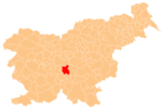
Hrastje pri Grosupljem (pronounced [ˈxɾaːstjɛ pɾi ɡɾɔˈsuːpljɛm]) is a settlement between Grosuplje and Šmarje-Sap in central Slovenia. The Slovenian A2 motorway runs across the settlement's territory. The area is part of the historical region of Lower Carniola. The Municipality of Grosuplje is now included in the Central Slovenia Statistical Region.[2]
Hrastje pri Grosupljem | |
|---|---|
 Hrastje pri Grosupljem Location in Slovenia | |
| Coordinates: 45°58′17.29″N 14°38′44.33″E | |
| Country | |
| Traditional region | Lower Carniola |
| Statistical region | Central Slovenia |
| Municipality | Grosuplje |
| Area | |
| • Total | 1.02 km2 (0.39 sq mi) |
| Elevation | 359.3 m (1,178.8 ft) |
| Population (2002) | |
| • Total | 60 |
| [1] | |
Name
The name of the settlement was changed from Hrastje to Hrastje pri Grosupljem (literally, 'Hrastje near Grosuplje') in 1955.[3] The name Hrastje is derived from the Slovene common noun hrast 'oak', referring to the local vegetation.[4]
References
- Statistical Office of the Republic of Slovenia
- Grosuplje municipal site
- Spremembe naselij 1948–95. 1996. Database. Ljubljana: Geografski inštitut ZRC SAZU, DZS.
- Snoj, Marko (2009). Etimološki slovar slovenskih zemljepisnih imen. Ljubljana: Modrijan. p. 163.
External links
Текст в блоке "Читать" взят с сайта "Википедия" и доступен по лицензии Creative Commons Attribution-ShareAlike; в отдельных случаях могут действовать дополнительные условия.
Другой контент может иметь иную лицензию. Перед использованием материалов сайта WikiSort.org внимательно изучите правила лицензирования конкретных элементов наполнения сайта.
Другой контент может иметь иную лицензию. Перед использованием материалов сайта WikiSort.org внимательно изучите правила лицензирования конкретных элементов наполнения сайта.
2019-2025
WikiSort.org - проект по пересортировке и дополнению контента Википедии
WikiSort.org - проект по пересортировке и дополнению контента Википедии
