world.wikisort.org - Russia
Alexandrovsk-Sakhalinsky (Russian: Алекса́ндровск-Сахали́нский, Japanese: Otchishi) is a town in Sakhalin Oblast, Russia, located near the Strait of Tartary on the western shores of northern Sakhalin Island at the foot of the western Sakhalin mountains. Population: 10,613 (2010 Census);[3] 12,826 (2002 Census);[9] 19,166 (1989 Census);[10] 21,000 (1968).
Alexandrovsk-Sakhalinsky
Александровск-Сахалинский | |
|---|---|
Town[1] | |
 | |
 Coat of arms | |
Location of Alexandrovsk-Sakhalinsky  | |
 Alexandrovsk-Sakhalinsky Location of Alexandrovsk-Sakhalinsky 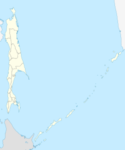 Alexandrovsk-Sakhalinsky Alexandrovsk-Sakhalinsky (Sakhalin Oblast) | |
| Coordinates: 50°54′N 142°09′E | |
| Country | Russia |
| Federal subject | Sakhalin Oblast[1] |
| Administrative district | Alexandrovsk-Sakhalinsky District[1] |
| Founded | 1862[2] |
| Town status since | 1917 |
| Elevation | 10 m (30 ft) |
| Population | |
| • Total | 10,613 |
| • Estimate (2018)[4] | 9,504 (−10.4%) |
Administrative status | |
| • Capital of | Alexandrovsk-Sakhalinsky District[1] |
Municipal status | |
| • Urban okrug | Alexandrovsk-Sakhalinsky Urban Okrug[5] |
| • Capital of | Alexandrovsk-Sakhalinsky Urban Okrug[5] |
| Time zone | UTC+11 (MSK+8 |
| Postal code(s)[7] | 694420–694424 |
| Dialing code(s) | +7 42434[8] |
| OKTMO ID | 64704000001 |
| Website | aleksandrovsk |
History
A settlement called Alexandrovskaya on the present site of the town was first recorded in 1862.[2] In 1869, an agricultural farm was established there, which later grew into the village of Alexandrovka. At the time, it was known as Ochiishi (落石, Ochīshi) among Japanese.
In 1881, a military post was established and became known as Alexandrovsky. The outpost served as the administrative center for managing katorga, prisons, exile settlements, and the whole island until the October Revolution. Anton Chekhov lived here in 1890 while gathering material for his book The Sakhalin Island.
Town status was granted to Alexandrovsky in 1917.[citation needed] During the Russian Civil War, the town was under the control of Admiral Alexander Kolchak in 1918–1920, before being occupied by the Japanese until 1925. It was known as Akō (亜港町, Akō-chō) "Street of Port Alexander" during Japanese occupation between 1918 and 1925.
In 1926, the town was renamed Alexandrovsk-Sakhalinsky to distinguish it from other places of the same name.
Alexandrovsk-Sakhalinsky was the administrative center of Sakhalin Oblast between 1932 and 1947. It was also known as the coal mining center of the island during Soviet times.
Administrative and municipal status
Within the framework of administrative divisions, Alexandrovsk-Sakhalinsky serves as the administrative center of Alexandrovsk-Sakhalinsky District and is subordinated to it.[1] As a municipal division, the town of Alexandrovsk-Sakhalinsky and thirteen rural localities of Alexandrovsk-Sakhalinsky District are incorporated as Alexandrovsk-Sakhalinsky Urban Okrug.[5]
Economy and infrastructure
The economy of Alexandrovsk-Sakhalinsky is mainly reliant on its harbor, the oldest and previously most important on Sakhalin, and the mining of black coal in the local area.
Climate
Alexandrovsk-Sakhalinsky has a humid continental climate (Köppen climate classification Dfb)[11] with short mild to warm summers and long, cold winters.
| Climate data for Alexandrovsk-Sakhalinsky (1991–2020, extremes 1881–present) | |||||||||||||
|---|---|---|---|---|---|---|---|---|---|---|---|---|---|
| Month | Jan | Feb | Mar | Apr | May | Jun | Jul | Aug | Sep | Oct | Nov | Dec | Year |
| Record high °C (°F) | 4.7 (40.5) |
5.4 (41.7) |
11.4 (52.5) |
20.9 (69.6) |
28.1 (82.6) |
29.4 (84.9) |
32.0 (89.6) |
31.3 (88.3) |
28.6 (83.5) |
21.2 (70.2) |
13.8 (56.8) |
5.7 (42.3) |
32.0 (89.6) |
| Average high °C (°F) | −11.3 (11.7) |
−9.7 (14.5) |
−3.4 (25.9) |
4.0 (39.2) |
11.2 (52.2) |
16.0 (60.8) |
19.6 (67.3) |
20.6 (69.1) |
16.9 (62.4) |
9.1 (48.4) |
−0.9 (30.4) |
−8.6 (16.5) |
5.3 (41.5) |
| Daily mean °C (°F) | −15.4 (4.3) |
−14.4 (6.1) |
−7.6 (18.3) |
0.1 (32.2) |
6.3 (43.3) |
11.4 (52.5) |
15.5 (59.9) |
16.7 (62.1) |
12.7 (54.9) |
5.4 (41.7) |
−3.9 (25.0) |
−12.0 (10.4) |
1.2 (34.2) |
| Average low °C (°F) | −19.4 (−2.9) |
−18.8 (−1.8) |
−12.1 (10.2) |
−3.4 (25.9) |
2.4 (36.3) |
7.6 (45.7) |
12.0 (53.6) |
13.3 (55.9) |
9.0 (48.2) |
2.0 (35.6) |
−6.9 (19.6) |
−15.4 (4.3) |
−2.5 (27.5) |
| Record low °C (°F) | −41.0 (−41.8) |
−37.3 (−35.1) |
−34.2 (−29.6) |
−25.9 (−14.6) |
−8.9 (16.0) |
−2.4 (27.7) |
0.5 (32.9) |
1.5 (34.7) |
−2.5 (27.5) |
−15.0 (5.0) |
−26.0 (−14.8) |
−36.9 (−34.4) |
−41.0 (−41.8) |
| Average precipitation mm (inches) | 48 (1.9) |
31 (1.2) |
35 (1.4) |
34 (1.3) |
52 (2.0) |
45 (1.8) |
52 (2.0) |
96 (3.8) |
90 (3.5) |
88 (3.5) |
65 (2.6) |
70 (2.8) |
706 (27.8) |
| Average extreme snow depth cm (inches) | 27 (11) |
37 (15) |
41 (16) |
13 (5.1) |
0 (0) |
0 (0) |
0 (0) |
0 (0) |
0 (0) |
1 (0.4) |
6 (2.4) |
17 (6.7) |
41 (16) |
| Average rainy days | 0.2 | 0.04 | 0.3 | 7 | 17 | 15 | 16 | 19 | 20 | 19 | 5 | 1 | 120 |
| Average snowy days | 26 | 24 | 20 | 15 | 6 | 0.03 | 0 | 0 | 0.2 | 9 | 25 | 28 | 153 |
| Average relative humidity (%) | 80 | 79 | 75 | 74 | 76 | 80 | 84 | 82 | 79 | 74 | 75 | 80 | 78 |
| Mean monthly sunshine hours | 100 | 134 | 185 | 189 | 215 | 252 | 214 | 202 | 180 | 127 | 78 | 57 | 1,933 |
| Source 1: Pogoda.ru.net[12] | |||||||||||||
| Source 2: NOAA (sun, 1961–1990)[13] | |||||||||||||
Gallery
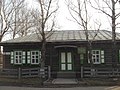 Anton Chekhov museum in Alexandrovsk-Sakhalinsky. It is the house where he stayed in Sakhalin during 1890
 Anton Chekhov monument in Alexandrovsk-Sakhalinsky
 "Three Brothers" rocks in Alexandrovsk-Sakhalinsky
 Settler's way of life. Near church at holiday. 1903
 Aleksandrovskaya Prison in Alexandrovsk-Sakhalinsky in 1903


References
Notes
- Law #25-ZO
- Энциклопедия Города России. Moscow: Большая Российская Энциклопедия. 2003. p. 17. ISBN 5-7107-7399-9.
- Russian Federal State Statistics Service (2011). Всероссийская перепись населения 2010 года. Том 1 [2010 All-Russian Population Census, vol. 1]. Всероссийская перепись населения 2010 года [2010 All-Russia Population Census] (in Russian). Federal State Statistics Service.
- http://www.gks.ru/free_doc/doc_2018/bul_dr/mun_obr2018.rar; archive date: 26 July 2018; archive URL: https://web.archive.org/web/20180726010024/http://www.gks.ru/free_doc/doc_2018/bul_dr/mun_obr2018.rar.
- Law No. 524
- "Об исчислении времени". Официальный интернет-портал правовой информации (in Russian). 3 June 2011. Retrieved 19 January 2019.
- Почта России. Информационно-вычислительный центр ОАСУ РПО. (Russian Post). Поиск объектов почтовой связи (Postal Objects Search) (in Russian)
- "Телефонные коды Сахалинской области. Сахалин.Бизнес Справочник" [Dialing codes of Sakhalin]. Sakhalin.biz (in Russian). Retrieved 25 December 2021.
- Russian Federal State Statistics Service (21 May 2004). Численность населения России, субъектов Российской Федерации в составе федеральных округов, районов, городских поселений, сельских населённых пунктов – районных центров и сельских населённых пунктов с населением 3 тысячи и более человек [Population of Russia, Its Federal Districts, Federal Subjects, Districts, Urban Localities, Rural Localities—Administrative Centers, and Rural Localities with Population of Over 3,000] (XLS). Всероссийская перепись населения 2002 года [All-Russia Population Census of 2002] (in Russian).
- Всесоюзная перепись населения 1989 г. Численность наличного населения союзных и автономных республик, автономных областей и округов, краёв, областей, районов, городских поселений и сёл-райцентров [All Union Population Census of 1989: Present Population of Union and Autonomous Republics, Autonomous Oblasts and Okrugs, Krais, Oblasts, Districts, Urban Settlements, and Villages Serving as District Administrative Centers]. Всесоюзная перепись населения 1989 года [All-Union Population Census of 1989] (in Russian). Институт демографии Национального исследовательского университета: Высшая школа экономики [Institute of Demography at the National Research University: Higher School of Economics]. 1989 – via Demoscope Weekly.
- "Aleksandrovsk-Sakhalinskiy climate: Average Temperature, weather by month, Aleksandrovsk-Sakhalinskiy water temperature - Climate-Data.org". en.climate-data.org. Retrieved 25 December 2021.
- "Pogoda.ru.net (Weather and Climate-The Climate of Alexandrovsk-Sakhalinsky)" (in Russian). Weather and Climate. Retrieved 8 November 2021.
- "Aleksandrovsk–Sahal (Alexandrovsk-Sakhalinsky) Climate Normals 1961–1990". National Oceanic and Atmospheric Administration. Retrieved 7 November 2021.
Sources
- Сахалинская областная Дума. Закон №25-ЗО от 23 марта 2011 г. «Об административно-территориальном устройстве Сахалинской области», в ред. Закона №62-ЗО от 27 июня 2013 г. «О внесении изменения в статью 10 Закона Сахалинской области "Об административно-территориальном устройстве Сахалинской области"». Вступил в силу 9 апреля 2011 г.. Опубликован: "Губернские ведомости", №55(3742), 29 марта 2011 г. (Sakhalin Oblast Duma. Law #25-ZO of March 23, 2011 On the Administrative-Territorial Structure of Sakhalin Oblast, as amended by the Law #62-ZO of June 27, 2013 On Amending Article 10 of the Law of Sakhalin Oblast "On the Administrative-Territorial Structure of Sakhalin Oblast". Effective as of April 9, 2011.).
- Сахалинская областная Дума. Закон №524 от 21 июля 2004 г. «О границах и статусе муниципальных образований в Сахалинской области», в ред. Закона №45-ЗО от 27 мая 2013 г. «О внесении изменения в Закон Сахалинской области "О границах и статусе муниципальных образований в Сахалинской области"». Вступил в силу 1 января 2005 г. Опубликован: "Губернские ведомости", №175–176(2111–2112), 31 июля 2004 г. (Sakhalin Oblast Duma. Law #524 of July 21, 2004 On the Borders and Status of the Municipal Formations in Sakhalin Oblast, as amended by the Law #45-ZO of May 27, 2013 On Amending the Law of Sakhalin Oblast "On the Borders and Status of the Municipal Formations in Sakhalin Oblast". Effective as of January 1, 2005.).
External links
 Media related to Alexandrovsk-Sakhalinsky at Wikimedia Commons
 Alexandrovsk-Sakhalinsky travel guide from Wikivoyage
- Official website of Alexandrovsk-Sakhalinsky (in Russian)
- Directory of organizations in Alexandrovsk-Sakhalinsky (in Russian)
Authority control | |
|---|---|
| General |
|
| National libraries | |
| Other |
|
На других языках
[de] Alexandrowsk-Sachalinski
Alexandrowsk-Sachalinski (russisch Алекса́ндровск-Сахали́нский) ist eine Stadt in der Oblast Sachalin (Russland) mit 10.613 Einwohnern (Stand 14. Oktober 2010).[1]- [en] Alexandrovsk-Sakhalinsky (town)
[ru] Александровск-Сахалинский
Алекса́ндровск-Сахали́нский — город (с 1917 года) в России, административный центр городского округа «Александровск-Сахалинский район» Сахалинской области России.Другой контент может иметь иную лицензию. Перед использованием материалов сайта WikiSort.org внимательно изучите правила лицензирования конкретных элементов наполнения сайта.
WikiSort.org - проект по пересортировке и дополнению контента Википедии