world.wikisort.org - Philippines
Tinambac, officially the Municipality of Tinambac (Central Bikol: Banwaan kan Tinambac; Tagalog: Bayan ng Tinambac), is a 1st class municipality in the province of Camarines Sur, Philippines. According to the 2020 census, it has a population of 70,176 people. [3]
Tinambac | |
|---|---|
Municipality | |
| Municipality of Tinambac | |
 San Pascual Baylon Parish Church | |
 Map of Camarines Sur with Tinambac highlighted | |
OpenStreetMap  | |
 Tinambac Location within the Philippines | |
| Coordinates: 13°49′06″N 123°19′28″E | |
| Country | Philippines |
| Region | Bicol Region |
| Province | Camarines Sur |
| District | 4th district |
| Founded | 1888 |
| Barangays | 44 (see Barangays) |
| Government | |
| • Type | Sangguniang Bayan |
| • Mayor | Ruel B. Tuy |
| • Vice Mayor | Edward Albert P. Prades |
| • Representative | Arnulf Bryan B. Fuentebella |
| • Municipal Council | Members |
| • Electorate | 40,465 voters (2019) |
| Area | |
| • Total | 351.62 km2 (135.76 sq mi) |
| Elevation | 76 m (249 ft) |
| Highest elevation | 1,972 m (6,470 ft) |
| Lowest elevation | 0 m (0 ft) |
| Population | |
| • Total | 70,176 |
| • Density | 200/km2 (520/sq mi) |
| • Households | 13,277 |
| Economy | |
| • Income class | 1st municipal income class |
| • Poverty incidence | 36.77% (2018)[4] |
| • Revenue | ₱260,326,753.10 (2020) |
| • Assets | ₱387,936,596.34 (2020) |
| • Expenditure | ₱218,269,582.73 (2020) |
| • Liabilities | ₱96,606,572.02 (2020) |
| Service provider | |
| • Electricity | Camarines Sur 2 Electric Cooperative (CASURECO 2) |
| • Water | Partido Water Supply System |
| Time zone | UTC+8 (PST) |
| ZIP code | 4426 |
| PSGC | |
| IDD : area code | +63 (0)54 |
| Native languages | Central Bikol Tagalog |
| Website | www |
History
This section does not cite any sources. (July 2022) |
The town of Tinambac was considered to be a trading center of villages surrounding the eastern side of Mt. Isarog . It was in this place where tobacco, then a prohibited product, was exchanged by the townspeople of Tinambac.
Its establishment as a separate municipality occurred during the latter part of the 18th century and this was known as the mission post of Himoragat. In 1829 when the Spanish administration divided the province of Camarines Sur into four districts, Tinambac fall under the District of Isarog.
A church was built atop a hill which still stands at present where the residents of this simple town give way to the celebration of its fiesta every 17th day of May. St. Pascual Baylon is the patron saint of this town.
Geography
Barangays
Tinambac is politically subdivided into 45 barangays.
- Agay-Ayan
- Antipolo
- Bagacay
- Banga
- Bolaobalite
- Bani
- Bataan
- Binalay (Poblacion)
- Buenavista
- Buyo
- Cagliliog
- Caloco
- Camagong
- Canayonan
- Cawaynan
- Daligan
- Filarca (Poblacion)
- La Purisima (Poblacion)
- Lupi
- Magsaysay (Camp 4)
- Magtang
- Malibtong
- Mananao
- La Medalla (Mile 9)
- New Caaluan
- Olag Grande
- Olag Pequeño
- Old Caaluan
- Pag-Asa
- Pantat
- Sagrada (Camp 6)
- Salvacion
- San Antonio
- San Isidro (Poblacion)
- San Jose (Tiltilan)
- San Pascual (Poblacion)
- San Ramon (Camp 7)
- San Roque
- San Vicente
- Santa Cruz (Poblacion)
- Sogod
- Tambang
- Tierra Nevada
- Union
- Salvacion Poblacion
Climate
| Climate data for Tinambac, Camarines Sur | |||||||||||||
|---|---|---|---|---|---|---|---|---|---|---|---|---|---|
| Month | Jan | Feb | Mar | Apr | May | Jun | Jul | Aug | Sep | Oct | Nov | Dec | Year |
| Average high °C (°F) | 31 (88) |
30 (86) |
33 (91) |
35 (95) |
36 (97) |
36 (97) |
35 (95) |
34 (93) |
35 (95) |
33 (91) |
32 (90) |
31 (88) |
33 (92) |
| Average low °C (°F) | 27 (81) |
27 (81) |
28 (82) |
30 (86) |
31 (88) |
31 (88) |
30 (86) |
30 (86) |
30 (86) |
29 (84) |
28 (82) |
28 (82) |
29 (84) |
| Average precipitation mm (inches) | 62.63 (2.47) |
114.71 (4.52) |
41.44 (1.63) |
56.32 (2.22) |
105.22 (4.14) |
175.86 (6.92) |
192.89 (7.59) |
110.61 (4.35) |
130.78 (5.15) |
546.13 (21.50) |
232.90 (9.17) |
462 (18.2) |
2,231.49 (87.86) |
| Average rainy days | 21 | 25 | 14 | 17 | 23 | 29 | 31 | 23 | 27 | 29 | 29 | 31 | 299 |
| Source: World Weather Online[5] | |||||||||||||
Demographics
| Year | Pop. | ±% p.a. |
|---|---|---|
| 1903 | 4,880 | — |
| 1918 | 5,507 | +0.81% |
| 1939 | 10,921 | +3.31% |
| 1948 | 14,103 | +2.88% |
| 1960 | 28,897 | +6.16% |
| 1970 | 36,357 | +2.32% |
| 1975 | 34,415 | −1.09% |
| 1980 | 39,621 | +2.86% |
| 1990 | 46,570 | +1.63% |
| 1995 | 49,185 | +1.03% |
| 2000 | 55,608 | +2.67% |
| 2007 | 59,125 | +0.85% |
| 2010 | 62,435 | +2.00% |
| 2015 | 67,572 | +1.52% |
| 2020 | 70,176 | +0.75% |
| Source: Philippine Statistics Authority [6] [7] [8][9] | ||
In the 2020 census, the population of Tinambac was 70,176 people, [3] with a density of 200 inhabitants per square kilometre or 520 inhabitants per square mile.
Bikol is the predominant language.
Economy
Total agricultural area is estimated to be 17,230 hectares (42,600 acres), 96% of which are planted with coconut. Only around 4% are devoted to rice, corn, banana and root crops. Fishponds cover around 464 hectares (1,150 acres) or 1.8% of the total agricultural area.
- Commercial establishments
- Producers Bank
- Palawan Express (remittance center)
- LCC Supermarket
- LCC Department Store
- RJVM Moonvic Groceries
Infrastructure
- Communication facilities
- 1 Post Office located in the Poblacion, staffed by a Post Master and mail carriers
- Telegraph service offered by local branch of National Telecommunications Office
- Branches of RCPI and LBC Air Cargo
- Land line communication facilities
- Health services
- Tinambac Municipal Hospital
- Medicare Community Hospital - Sogod, Tinambac
- RRB Maternity, Family Planning, and Lying-in Clinic
Gallery
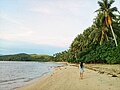 Caloco Beach
 View of Mount Isarog from Barangay San Antonio
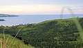 View of San Miguel Bay from Barangay San Antonio


References
- Municipality of Tinambac | (DILG)
- "2015 Census of Population, Report No. 3 – Population, Land Area, and Population Density" (PDF). Philippine Statistics Authority. Quezon City, Philippines. August 2016. ISSN 0117-1453. Archived (PDF) from the original on May 25, 2021. Retrieved July 16, 2021.
- Census of Population (2020). "Region V (Bicol Region)". Total Population by Province, City, Municipality and Barangay. PSA. Retrieved 8 July 2021.
- "PSA Releases the 2018 Municipal and City Level Poverty Estimates". Philippine Statistics Authority. 15 December 2021. Retrieved 22 January 2022.
- "Tinambac, Camarines Sur: Average Temperatures and Rainfall". World Weather Online. Retrieved 29 October 2017.
- Census of Population (2015). "Region V (Bicol Region)". Total Population by Province, City, Municipality and Barangay. PSA. Retrieved 20 June 2016.
- Census of Population and Housing (2010). "Region V (Bicol Region)". Total Population by Province, City, Municipality and Barangay. NSO. Retrieved 29 June 2016.
- Censuses of Population (1903–2007). "Region V (Bicol Region)". Table 1. Population Enumerated in Various Censuses by Province/Highly Urbanized City: 1903 to 2007. NSO.
- "Province of Camarines Sur". Municipality Population Data. Local Water Utilities Administration Research Division. Retrieved 17 December 2016.
- "Poverty incidence (PI):". Philippine Statistics Authority. Retrieved 28 December 2020.
- https://psa.gov.ph/sites/default/files/NSCB_LocalPovertyPhilippines_0.pdf; publication date: 29 November 2005; publisher: Philippine Statistics Authority.
- https://psa.gov.ph/sites/default/files/2003%20SAE%20of%20poverty%20%28Full%20Report%29_1.pdf; publication date: 23 March 2009; publisher: Philippine Statistics Authority.
- https://psa.gov.ph/sites/default/files/2006%20and%202009%20City%20and%20Municipal%20Level%20Poverty%20Estimates_0_1.pdf; publication date: 3 August 2012; publisher: Philippine Statistics Authority.
- https://psa.gov.ph/sites/default/files/2012%20Municipal%20and%20City%20Level%20Poverty%20Estima7tes%20Publication%20%281%29.pdf; publication date: 31 May 2016; publisher: Philippine Statistics Authority.
- https://psa.gov.ph/sites/default/files/City%20and%20Municipal-level%20Small%20Area%20Poverty%20Estimates_%202009%2C%202012%20and%202015_0.xlsx; publication date: 10 July 2019; publisher: Philippine Statistics Authority.
- "PSA Releases the 2018 Municipal and City Level Poverty Estimates". Philippine Statistics Authority. 15 December 2021. Retrieved 22 January 2022.
External links
- Philippine Standard Geographic Code
- Philippine Census Information
- Official site of the province of Camarines Sur/Tinambac
Places adjacent to Tinambac | ||||||||||||||||
|---|---|---|---|---|---|---|---|---|---|---|---|---|---|---|---|---|
| ||||||||||||||||
Statistically grouped with the Province of Camarines Sur | |||||||
| Administrative divisions |
|  | |||||
| Geography | |||||||
| History | |||||||
| Religion |
| ||||||
| Public utilities and services |
| ||||||
| Transportation |
| ||||||
| Education |
| ||||||
| Landmarks |
| ||||||
| |||||||
Pili (capital) | |
| Municipalities | |
| Component city | |
| Independent component city |
|

На других языках
[de] Tinambac
Tinambac ist eine philippinische Stadtgemeinde in der Provinz Camarines Sur.- [en] Tinambac
Другой контент может иметь иную лицензию. Перед использованием материалов сайта WikiSort.org внимательно изучите правила лицензирования конкретных элементов наполнения сайта.
WikiSort.org - проект по пересортировке и дополнению контента Википедии