world.wikisort.org - Norway
Utsira (pronounced [ˈʉ̌ːtˌsiːrɑ]) is the smallest municipality in Norway. The island municipality is located in northwestern Rogaland county, just off the western coast of Norway. Utsira is part of the traditional district of Haugaland.
Utsira kommune | |
|---|---|
Municipality | |
 View of the Utsira harbor | |
 Flag  Coat of arms  Rogaland within Norway | |
 Utsira within Rogaland | |
| Coordinates: 59°18′26″N 04°53′10″E | |
| Country | Norway |
| County | Rogaland |
| District | Haugaland |
| Established | 1 July 1924 |
| • Preceded by | Torvastad Municipality |
| Administrative centre | Utsira |
| Government | |
| • Mayor (2012) | Marte Eide Klovning (Ap) |
| Area | |
| • Total | 6.32 km2 (2.44 sq mi) |
| • Land | 6.29 km2 (2.43 sq mi) |
| • Water | 0.03 km2 (0.01 sq mi) 0.5% |
| • Rank | #355 in Norway |
| Population (2022) | |
| • Total | 188 |
| • Rank | #356 in Norway |
| • Density | 29.9/km2 (77/sq mi) |
| • Change (10 years) | |
| Demonym | Sirabu[1] |
| Official language | |
| • Norwegian form | Neutral |
| Time zone | UTC+01:00 (CET) |
| • Summer (DST) | UTC+02:00 (CEST) |
| ISO 3166 code | NO-1151 |
| Website | Official website |
The municipality consists of the main island of Utsira as well as several small, uninhabited outlying islands. Utsira is located in the North Sea, about 18 kilometres (11 miles) west of the town of Haugesund. All of the 206 residents (as of 2015[update]) live on the main island of Utsira, where the administrative centre and Utsira Church are located.
The 6-square-kilometre (2.3 sq mi) municipality is the 355th largest by area out of the 356 municipalities in Norway, making it the second smallest municipality in Norway after the nearby island municipality of Kvitsøy. Utsira is the 356th most populous municipality in Norway with a population of 188, making it the smallest municipality in Norway by population. The municipality's population density is 29.9 inhabitants per square kilometre (77/sq mi) and its population has decreased by 13.8% over the previous 10-year period.[3][4]
General information


The municipality of Utsira was established on 1 July 1924 when it was separated from the municipality of Torvastad. Initially, Utsira had 414 residents. The municipal borders have not changed since that time.[5]
Name
The municipality was named after the island of Utsira which makes up the vast majority of the municipality. The Old Norse forms of the island's name was just Síri (nominative) or Síra (genitive). The first element ut was added in the 16th century (ut means "out" or "offshore"; compare the "Out Skerries" in Shetland).
The inhabitants still call the island Sira (leaving off the ut prefix) and an inhabitant of the municipality is called a sirabu. The meaning of the name Sira is unknown (maybe "strong stream"). (Sira is also the name of the border river between Rogaland and Agder counties.)
The Norwegian language has had several spelling reforms during the 19th and 20th centuries. Before 1875, the name was written "Udsire", from 1875 to 1924 it was spelled "Utsire", and since 1925 it has used the spelling "Utsira".[6]
Coat of arms
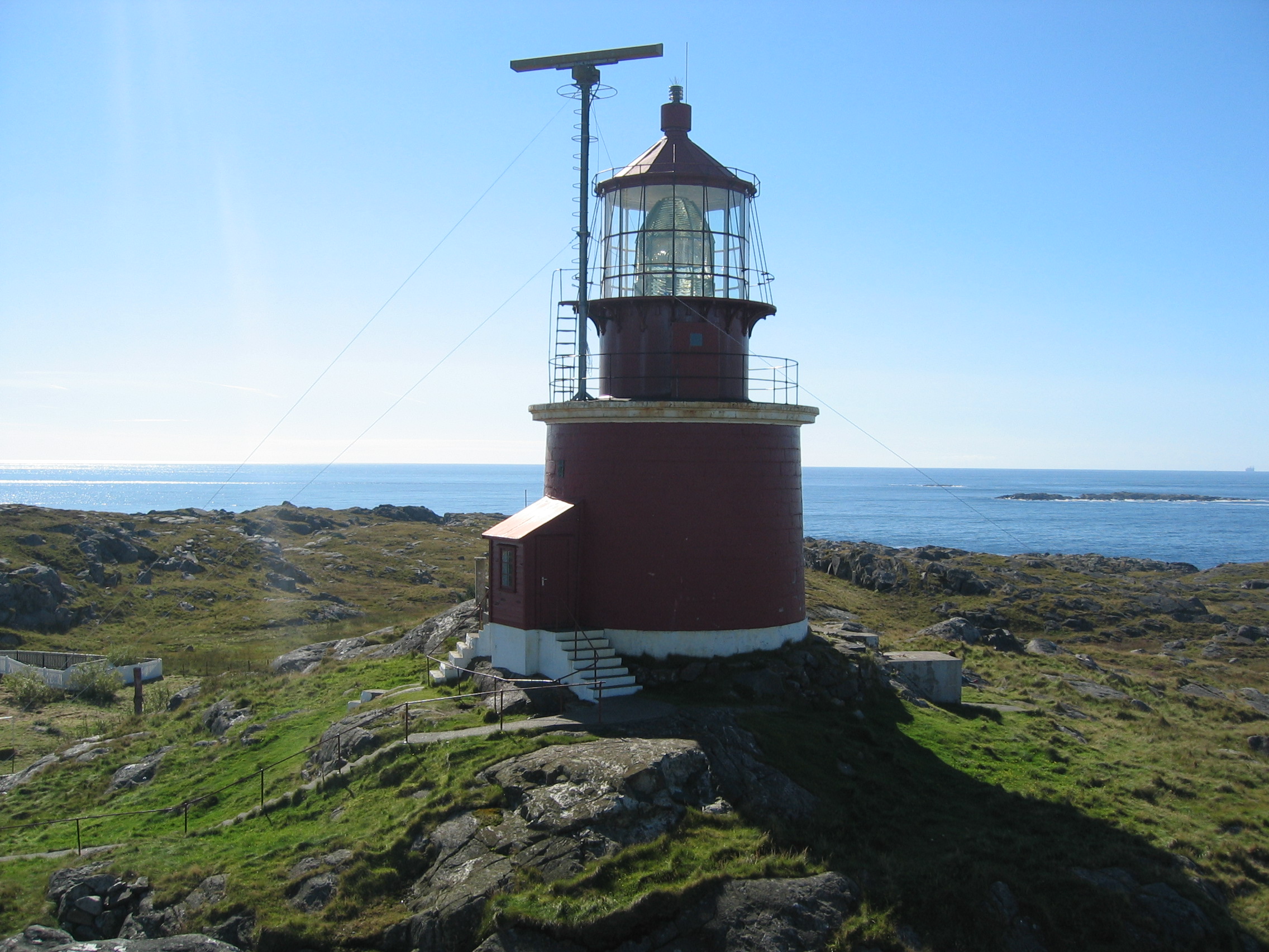
The coat of arms, granted on 23 July 1982, represents the light beams emerging from the local Utsira Lighthouse. The lighthouse was founded in 1844 and is one of the main landmarks on the municipality.[7]
Churches
The Church of Norway has one parish (sokn) within the municipality of Utsira. It is part of the Haugaland prosti (deanery) in the Diocese of Stavanger.
| Parish (sokn) | Church name | Location of the church | Year built |
|---|---|---|---|
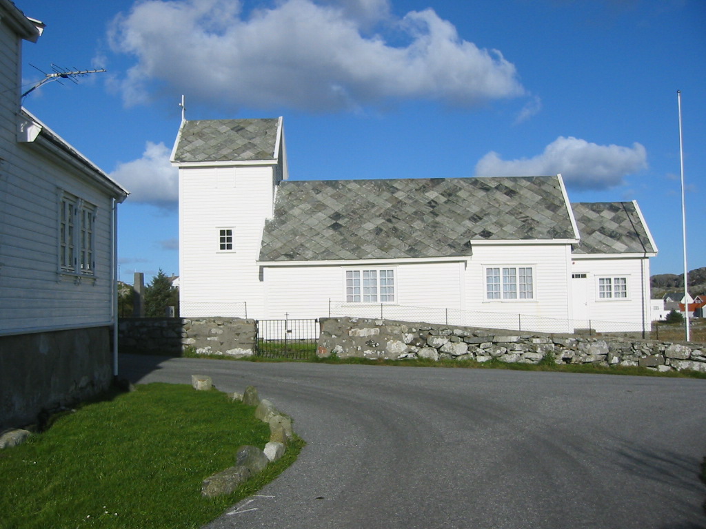
| Utsira | Utsira Church | Utsira | 1785 |
Transportation
The island municipality is only accessible by boat. There are roads on the island. A car ferry operated by Rutebåten Utsira runs four round-trips per day connecting the island to the town of Haugesund on the mainland. The trip takes about 70 minutes each way. There are ferry docks on the north and south side of the island. The northern port is more often used because the southern route takes a little longer; the southern is used if the weather demands. An ambulance helicopter can land at the football field in medical emergencies.[8]
Government
All municipalities in Norway, including Utsira, are responsible for primary education (through 10th grade), outpatient health services, senior citizen services, unemployment and other social services, zoning, economic development, and municipal roads. The municipality is governed by a municipal council of elected representatives, which in turn elect a mayor.[9] The municipality falls under the Haugaland og Sunnhordland District Court and the Gulating Court of Appeal.
Municipal council
The municipal council (Kommunestyre) of Utsira is made up of 11 representatives that are elected to four year terms. Currently, the party breakdown is as follows:
| Party Name (in Norwegian) | Number of representatives | |
|---|---|---|
| Utsira Common List (Utsira Fellesliste) | 8 | |
| Utsira Local List (Utsira Bygdeliste) | 3 | |
| Total number of members: | 11 | |
| Party Name (in Norwegian) | Number of representatives | |
|---|---|---|
| Utsira Common List (Utsira Fellesliste) | 6 | |
| Utsira Local List (Utsira Bygdeliste) | 5 | |
| Total number of members: | 11 | |
| Party Name (in Norwegian) | Number of representatives | |
|---|---|---|
| Utsira Common List (Utsira Fellesliste) | 9 | |
| Youth list for Utsira (Ungdomslista for Utsira) | 2 | |
| Total number of members: | 11 | |
| Party Name (in Norwegian) | Number of representatives | |
|---|---|---|
| Utsira common list (Utsira fellesliste) | 6 | |
| Local list for Utsira (Bygdelista for Utsira) | 5 | |
| Total number of members: | 11 | |
| Party Name (in Norwegian) | Number of representatives | |
|---|---|---|
| Labour Party (Arbeiderpartiet) | 6 | |
| Local politics list (Lokalpolitisk liste) | 2 | |
| Local list for Utsira (Bygdelista for Utsira) | 5 | |
| Total number of members: | 13 | |
| Party Name (in Norwegian) | Number of representatives | |
|---|---|---|
| Labour Party (Arbeiderpartiet) | 4 | |
| Cross-party list (Tverrpolitisk liste) | 9 | |
| Total number of members: | 13 | |
| Party Name (in Norwegian) | Number of representatives | |
|---|---|---|
| Labour Party (Arbeiderpartiet) | 4 | |
| Cross-party list (Tverrpolitisk liste) | 6 | |
| Local list for Utsira (Bygdelista for Utsira) | 3 | |
| Total number of members: | 13 | |
| Party Name (in Norwegian) | Number of representatives | |
|---|---|---|
| Labour Party (Arbeiderpartiet) | 4 | |
| Cross-party list (Tverrpolitisk liste) | 5 | |
| Local list for Utsira (Bygdelista for Utsira) | 4 | |
| Total number of members: | 13 | |
| Party Name (in Norwegian) | Number of representatives | |
|---|---|---|
| Labour Party (Arbeiderpartiet) | 6 | |
| Joint List(s) of Non-Socialist Parties (Borgerlige Felleslister) | 7 | |
| Total number of members: | 13 | |
| Party Name (in Norwegian) | Number of representatives | |
|---|---|---|
| Labour Party (Arbeiderpartiet) | 3 | |
| Conservative Party (Høyre) | 4 | |
| Local list for Utsira (Bygdeliste for Utsira) | 6 | |
| Total number of members: | 13 | |
| Party Name (in Norwegian) | Number of representatives | |
|---|---|---|
| Joint List(s) of Non-Socialist Parties (Borgerlige Felleslister) | 5 | |
| Women's list (Kvinnelista) | 2 | |
| Non-party list (Upolitisk liste) | 6 | |
| Total number of members: | 13 | |
| Party Name (in Norwegian) | Number of representatives | |
|---|---|---|
| Christian Democratic Party (Kristelig Folkeparti) | 1 | |
| Joint List(s) of Non-Socialist Parties (Borgerlige Felleslister) | 7 | |
| Non-party list (Upolitisk liste) | 5 | |
| Total number of members: | 13 | |
| Party Name (in Norwegian) | Number of representatives | |
|---|---|---|
| Local List(s) (Lokale lister) | 13 | |
| Total number of members: | 13 | |
| Party Name (in Norwegian) | Number of representatives | |
|---|---|---|
| Local List(s) (Lokale lister) | 13 | |
| Total number of members: | 13 | |
| Party Name (in Norwegian) | Number of representatives | |
|---|---|---|
| Local List(s) (Lokale lister) | 13 | |
| Total number of members: | 13 | |
| Party Name (in Norwegian) | Number of representatives | |
|---|---|---|
| Local List(s) (Lokale lister) | 13 | |
| Total number of members: | 13 | |
| Party Name (in Norwegian) | Number of representatives | |
|---|---|---|
| Local List(s) (Lokale lister) | 13 | |
| Total number of members: | 13 | |
| Party Name (in Norwegian) | Number of representatives | |
|---|---|---|
| Local List(s) (Lokale lister) | 12 | |
| Total number of members: | 12 | |
| Party Name (in Norwegian) | Number of representatives | |
|---|---|---|
| Joint List(s) of Non-Socialist Parties (Borgerlige Felleslister) | 3 | |
| Local List(s) (Lokale lister) | 9 | |
| Total number of members: | 12 | |
| Party Name (in Norwegian) | Number of representatives | |
|---|---|---|
| Local List(s) (Lokale lister) | 12 | |
| Total number of members: | 12 | |
| Party Name (in Norwegian) | Number of representatives | |
|---|---|---|
| Local List(s) (Lokale lister) | 12 | |
| Total number of members: | 12 | |
| Note: Due to the German occupation of Norway during World War II, no elections were held for new municipal councils until after the war ended in 1945. | ||
History
There are remains from the Stone Age on the island. It has been populated since that time. Historically, the island was governed by Torvastad, based on the mainland, but on 1 July 1924 the island was separated and it was established as a separate municipality. At that time, a new municipal council was to be elected. It was intended that the twelve men on the interim council would be elected, but the official list of candidates listed eleven women and a man. This was not known to even the people involved until the day of the election and by then it was too late. Despite a legal challenge the twelve were elected and Aasa Helgesen, the local midwife, was elected the first Mayor of Utsira and the first female mayor in Norway. Helgesen was a successful Mayor until 1928.[28]
In 2004, Norsk Hydro installed a combined wind-hydrogen utility on Utsira. It is a full scale pilot project for energy self-sufficiency for a remote community. In periods when there is surplus wind energy, the excess power will be used for generating hydrogen by electrolysis. The hydrogen is stored, and is available for power generation in periods where there is little wind. Additional to this an energy storing flywheel exists to help out when for a short time more power is needed.
Climate
Utsira has an oceanic climate (Cfb) with short, cool summers and long, chilly winters with lots of rainfall.
The island has significant seasonal lag with February–March typically being the coldest months of the year while August is the warmest. The maritime position also renders low diurnal variation in temperature between day and night.
| Climate data for Utsira fyr 2000-2020 | |||||||||||||
|---|---|---|---|---|---|---|---|---|---|---|---|---|---|
| Month | Jan | Feb | Mar | Apr | May | Jun | Jul | Aug | Sep | Oct | Nov | Dec | Year |
| Record high °C (°F) | 10 (50) |
10 (50) |
14.8 (58.6) |
21.2 (70.2) |
23 (73) |
26.5 (79.7) |
29.3 (84.7) |
27 (81) |
23.3 (73.9) |
16.4 (61.5) |
12.8 (55.0) |
10.6 (51.1) |
29.3 (84.7) |
| Mean maximum °C (°F) | 7.8 (46.0) |
7.2 (45.0) |
8 (46) |
13 (55) |
17.8 (64.0) |
19.1 (66.4) |
21.4 (70.5) |
21 (70) |
17.9 (64.2) |
14.1 (57.4) |
10.7 (51.3) |
8.9 (48.0) |
21.4 (70.5) |
| Average high °C (°F) | 5.2 (41.4) |
4.4 (39.9) |
5.7 (42.3) |
8.0 (46.4) |
11.3 (52.3) |
13.8 (56.8) |
16.3 (61.3) |
17.1 (62.8) |
14.8 (58.6) |
11.5 (52.7) |
8.5 (47.3) |
6.5 (43.7) |
10.3 (50.5) |
| Daily mean °C (°F) | 3.6 (38.5) |
2.8 (37.0) |
3.5 (38.3) |
6.1 (43.0) |
9.1 (48.4) |
11.6 (52.9) |
14.3 (57.7) |
15.3 (59.5) |
13.2 (55.8) |
10.0 (50.0) |
7.0 (44.6) |
4.9 (40.8) |
8.5 (47.2) |
| Average low °C (°F) | 2.1 (35.8) |
1.3 (34.3) |
1.4 (34.5) |
4.2 (39.6) |
6.9 (44.4) |
9.7 (49.5) |
12.5 (54.5) |
13.5 (56.3) |
11.7 (53.1) |
8.6 (47.5) |
5.5 (41.9) |
3.4 (38.1) |
6.7 (44.1) |
| Mean minimum °C (°F) | −3.3 (26.1) |
−3.4 (25.9) |
−2.4 (27.7) |
−0.2 (31.6) |
3.1 (37.6) |
6.8 (44.2) |
9.5 (49.1) |
10 (50) |
7.3 (45.1) |
3.7 (38.7) |
0 (32) |
−2.4 (27.7) |
−3.4 (25.9) |
| Record low °C (°F) | −13.1 (8.4) |
−10.4 (13.3) |
−6.8 (19.8) |
−3.1 (26.4) |
−1.4 (29.5) |
4 (39) |
6.8 (44.2) |
8 (46) |
4.1 (39.4) |
0 (32) |
−6.2 (20.8) |
−6.5 (20.3) |
−13.1 (8.4) |
| Average precipitation mm (inches) | 129 (5.1) |
91 (3.6) |
99 (3.9) |
64 (2.5) |
55 (2.2) |
58 (2.3) |
77 (3.0) |
115 (4.5) |
121 (4.8) |
154 (6.1) |
141 (5.6) |
119 (4.7) |
1,223 (48.3) |
| Source: Norwegian Meteorological Institute (eKlima) | |||||||||||||
Shipping forecast
Utsira (under the spelling Utsire) gives its name to "North Utsire" and "South Utsire", two of the sea areas of the British Shipping Forecast.
Notable people
- Aasa Helgesen (1877–1968) a Norwegian midwife and politician. She served as Mayor of Utsira from 1926 to 1928, and was the first female mayor in Norway. She worked as a midwife in Utsira from 1903 to 1942.
Attractions
Utsira Lighthouse is the highest lighthouse light in Norway at 78.2 metres (257 ft) above mean sea level.
 View of Utsira Lighthouse
 Lighthouse tower
 Utsira lighthouse sign


Birding
Utsira is known as the best birding site in Norway. There have been 317 different species recorded on Utsira, of which 23 are new to Norway.
References
- "Navn på steder og personer: Innbyggjarnamn" (in Norwegian). Språkrådet.
- "Forskrift om målvedtak i kommunar og fylkeskommunar" (in Norwegian). Lovdata.no.
- Statistisk sentralbyrå. "Table: 06913: Population 1 January and population changes during the calendar year (M)" (in Norwegian).
- Statistisk sentralbyrå. "09280: Area of land and fresh water (km²) (M)" (in Norwegian).
- Jukvam, Dag (1999). "Historisk oversikt over endringer i kommune- og fylkesinndelingen" (PDF) (in Norwegian). Statistisk sentralbyrå.
- Store norske leksikon. "Utsira" (in Norwegian). Retrieved 22 October 2015.
- "Civic heraldry of Norway - Norske Kommunevåpen". Heraldry of the World. Retrieved 22 October 2015.
- Sykepleieren som må gjøre alt
- Hansen, Tore, ed. (12 May 2016). "kommunestyre". Store norske leksikon (in Norwegian). Kunnskapsforlaget. Retrieved 28 June 2020.
- "Tall for Norge: Kommunestyrevalg 2019 - Rogaland". Valg Direktoratet. Retrieved 2 July 2020.
- "Table: 04813: Members of the local councils, by party/electoral list at the Municipal Council election (M)" (in Norwegian). Statistics Norway.
- "Tall for Norge: Kommunestyrevalg 2011 - Rogaland". Valg Direktoratet. Retrieved 2 July 2020.
- "Kommunestyrevalget 1995" (PDF) (in Norwegian). Oslo-Kongsvinger: Statistisk sentralbyrå. 1996. Retrieved 2 July 2020.
- "Kommunestyrevalget 1991" (PDF) (in Norwegian). Oslo-Kongsvinger: Statistisk sentralbyrå. 1993. Retrieved 2 July 2020.
- "Kommunestyrevalget 1987" (PDF) (in Norwegian). Oslo-Kongsvinger: Statistisk sentralbyrå. 1988. Retrieved 2 July 2020.
- "Kommunestyrevalget 1983" (PDF) (in Norwegian). Oslo-Kongsvinger: Statistisk sentralbyrå. 1984. Retrieved 2 July 2020.
- "Kommunestyrevalget 1979" (PDF) (in Norwegian). Oslo: Statistisk sentralbyrå. 1979. Retrieved 2 July 2020.
- "Kommunevalgene 1975" (PDF) (in Norwegian). Oslo: Statistisk sentralbyrå. 1977. Retrieved 2 July 2020.
- "Kommunevalgene 1972" (PDF) (in Norwegian). Oslo: Statistisk sentralbyrå. 1973. Retrieved 2 July 2020.
- "Kommunevalgene 1967" (PDF) (in Norwegian). Oslo: Statistisk sentralbyrå. 1967. Retrieved 2 July 2020.
- "Kommunevalgene 1963" (PDF) (in Norwegian). Oslo: Statistisk sentralbyrå. 1964. Retrieved 2 July 2020.
- "Kommunevalgene og Ordførervalgene 1959" (PDF) (in Norwegian). Oslo: Statistisk sentralbyrå. 1960. Retrieved 2 July 2020.
- "Kommunevalgene og Ordførervalgene 1955" (PDF) (in Norwegian). Oslo: Statistisk sentralbyrå. 1957. Retrieved 2 July 2020.
- "Kommunevalgene og Ordførervalgene 1951" (PDF) (in Norwegian). Oslo: Statistisk sentralbyrå. 1952. Retrieved 2 July 2020.
- "Kommunevalgene og Ordførervalgene 1947" (PDF) (in Norwegian). Oslo: Statistisk sentralbyrå. 1948. Retrieved 2 July 2020.
- "Kommunevalgene og Ordførervalgene 1945" (PDF) (in Norwegian). Oslo: Statistisk sentralbyrå. 1947. Retrieved 2 July 2020.
- "Kommunevalgene og Ordførervalgene 1937" (PDF) (in Norwegian). Oslo: Statistisk sentralbyrå. 1938. Retrieved 2 July 2020.
- Baastad, Siri (15 December 1999). "Jordmor Helgesens "skjørteregime"". Kommunal Rapport (in Norwegian). Retrieved 20 February 2014.
External links
 Media related to Utsira at Wikimedia Commons
 The dictionary definition of Utsira at Wiktionary
 Rogaland travel guide from Wikivoyage
- Municipal fact sheet from Statistics Norway (in Norwegian)
- Municipality web site (in Norwegian)
- Map
- Birding on Utsira (in Norwegian)
Rogaland county, Norway | |||||||
|---|---|---|---|---|---|---|---|
| |||||||
 | Towns and cities |
|  | ||||
| Municipalities | |||||||
На других языках
[de] Utsira
Utsira ist eine Insel in der Nordsee 18 km westlich vor Karmøy und die kleinste Kommune Norwegens. Sie liegt im Fylke Rogaland. Die Insel ist Namensgeber für das gleichnamige Seegebiet.- [en] Utsira
[ru] Утсира
Утсира (норв. Utsira) — коммуна в губернии Ругаланн в Норвегии. Административный центр коммуны — город Утсира. Официальный язык коммуны — нейтральный[2]. Население коммуны на 2015 год составляло 200 человек. Площадь коммуны Утсира — 01,06,2029 км², код-идентификатор — 1151.Другой контент может иметь иную лицензию. Перед использованием материалов сайта WikiSort.org внимательно изучите правила лицензирования конкретных элементов наполнения сайта.
WikiSort.org - проект по пересортировке и дополнению контента Википедии