world.wikisort.org - Norway
Sokndal is the southernmost municipality in Rogaland county, Norway. It is located in the traditional district of Dalane. The administrative centre of the municipality is the village of Hauge. Other villages in Sokndal include Li, Rekefjord, Sogndalsstranda, and Åna-Sira.
Sokndal kommune | |
|---|---|
Municipality | |
 View of Sogndalsstranda | |
 Flag  Coat of arms  Rogaland within Norway | |
 Sokndal within Rogaland | |
| Coordinates: 58°21′54″N 06°18′37″E | |
| Country | Norway |
| County | Rogaland |
| District | Dalane |
| Established | 1 Jan 1838 |
| • Created as | Formannskapsdistrikt |
| Administrative centre | Hauge i Dalene |
| Government | |
| • Mayor (2019) | Jonas Andersen Sayed (KrF) |
| Area | |
| • Total | 294.98 km2 (113.89 sq mi) |
| • Land | 267.15 km2 (103.15 sq mi) |
| • Water | 27.83 km2 (10.75 sq mi) 9.4% |
| • Rank | #267 in Norway |
| Population (2022) | |
| • Total | 3,281 |
| • Rank | #219 in Norway |
| • Density | 12.3/km2 (32/sq mi) |
| • Change (10 years) | |
| Demonym | Sokndøl[1] |
| Official language | |
| • Norwegian form | Neutral |
| Time zone | UTC+01:00 (CET) |
| • Summer (DST) | UTC+02:00 (CEST) |
| ISO 3166 code | NO-1111 |
| Website | Official website |
Sogndalsstranda is a picturesque, old fishing village, which may have inspired the municipality in becoming Norway's first member of Cittaslow. The Jøssingfjorden, known for the Altmark Incident, is also located in Sokndal.
The 295-square-kilometre (114 sq mi) municipality is the 267th largest by area out of the 356 municipalities in Norway. Sokndal is the 219th most populous municipality in Norway with a population of 3,281. The municipality's population density is 12.3 inhabitants per square kilometre (32/sq mi) and its population has increased by 0.7% over the previous 10-year period.[3][4]
General information


The parish of Soggendal (later Sokndal) was established as a municipality on 1 January 1838 (see formannskapsdistrikt law). In 1845, the small lading place of Sogndal (population: 348) was separated from Sokndal as a municipality of its own. This left Sokndal with 2,819 residents. On 12 December 1868, a small part of Sokndal (population: 41) was transferred to neighboring Eigersund municipality. On 1 July 1944, the small lading place of Sogndal (population: 311) was reincorporated into Sokndal. In 1947, a small area in Sokndal (population: 7) was transferred to Eigersund. On 1 January 1967, the Tjørn farm (population: 10) was transferred from Eigersund to Sokndal.[5]
Name
The Old Norse form of the name was Sóknardalr. The first element is the genitive case of the river name Sókn (now Sokno) and the last element is dalr which means "valley" or "dale". The river name is derived from the Old Norse verb sœkja which means "seek" and so the meaning is "the river which seeks (finds/forces) its way". Before 1918, the name was written "Sogndal" or "Soggendahl".[6]
Coat of arms
The coat of arms was granted on 8 July 1988. The arms show three black pickaxes on a yellow background. These were chosen to symbolize the importance of mining and agriculture in the municipality. It was designed by Johan Digernes of Haugesund.[7]
Churches
The Church of Norway has one parish (sokn) within the municipality of Sokndal. It is part of the Dalane prosti (deanery) in the Diocese of Stavanger.
| Parish (sokn) | Church name | Location of the church | Year built |
|---|---|---|---|
| Sokndal | Sokndal Church | Hauge | 1803 |
| Åna-Sira Church | Åna-Sira | 1888 |
Geography
The municipality is the southernmost in Rogaland county. The North Sea lies to the south and west, the river Sira and the Åna fjord lie to the southeast (separating it from Flekkefjord in Agder county), the municipality of Lund lies to the east and north, and the municipality of Eigersund lies to the northwest. The lakes Grøsfjellvatnet and Eiavatnet both lie on the northern border of the municipality. The coastline of Sokndal is fairly smooth, although there are two larger fjords which cut into the municipality: the Rekefjorden and Jøssingfjorden. The Lille Presteskjær Lighthouse marks the entrance to the Rekefjorden. The southeastern part of the municipality is very rocky and rugged. It is the site of the large Tellnes mine, a large producer of titanium.[8]
Climate
| Climate data for Hauge | |||||||||||||
|---|---|---|---|---|---|---|---|---|---|---|---|---|---|
| Month | Jan | Feb | Mar | Apr | May | Jun | Jul | Aug | Sep | Oct | Nov | Dec | Year |
| Daily mean °C (°F) | −0.3 (31.5) |
−0.5 (31.1) |
1.6 (34.9) |
4.7 (40.5) |
9.7 (49.5) |
13.1 (55.6) |
14.6 (58.3) |
14.4 (57.9) |
11.3 (52.3) |
8.2 (46.8) |
3.9 (39.0) |
0.9 (33.6) |
6.8 (44.2) |
| Average precipitation mm (inches) | 150 (5.9) |
105 (4.1) |
120 (4.7) |
85 (3.3) |
93 (3.7) |
98 (3.9) |
118 (4.6) |
150 (5.9) |
190 (7.5) |
210 (8.3) |
193 (7.6) |
163 (6.4) |
1,675 (65.9) |
| Source: Norwegian Meteorological Institute[9] | |||||||||||||
Economy
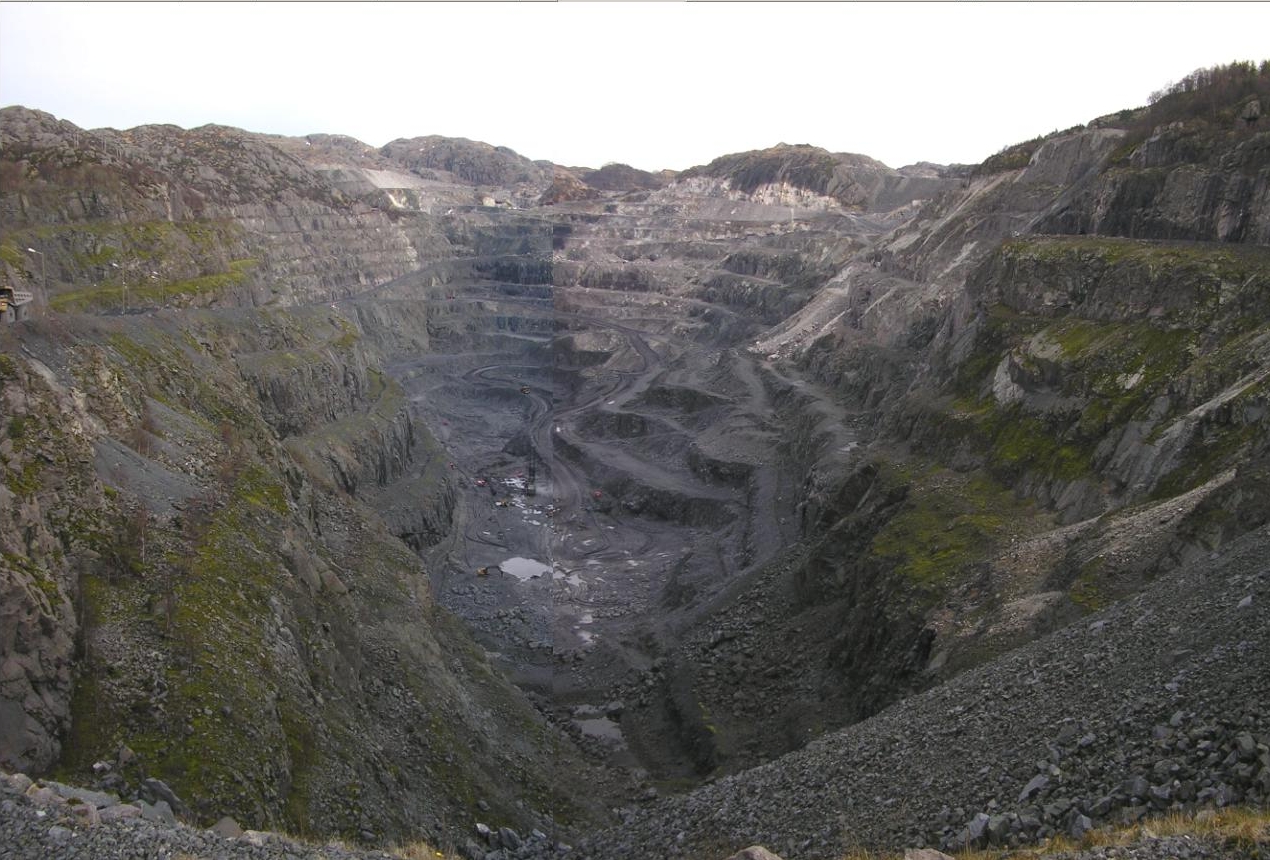
At Tellnes, just east of Hauge i Dalane, there is an ilmenite mine run by Titania AS, supplying 10% of the world production of ilmenite (a type of titanium). It's also the world's largest opencast ilmenite mine.
Government
All municipalities in Norway, including Sokndal, are responsible for primary education (through 10th grade), outpatient health services, senior citizen services, unemployment and other social services, zoning, economic development, and municipal roads. The municipality is governed by a municipal council of elected representatives, which in turn elect a mayor.[10] The municipality falls under the Sør-Rogaland District Court and the Gulating Court of Appeal.
Municipal council
The municipal council (Kommunestyre) of Sokndal is made up of 21 representatives that are elected to four year terms. Currently, the party breakdown is as follows:
| Party Name (in Norwegian) | Number of representatives | |
|---|---|---|
| Labour Party (Arbeiderpartiet) | 5 | |
| Progress Party (Fremskrittspartiet) | 2 | |
| Conservative Party (Høyre) | 2 | |
| Christian Democratic Party (Kristelig Folkeparti) | 5 | |
| Centre Party (Senterpartiet) | 3 | |
| Liberal Party (Venstre) | 1 | |
| Sokndal List (Sokndal Listo) | 3 | |
| Total number of members: | 21 | |
| Party Name (in Norwegian) | Number of representatives | |
|---|---|---|
| Labour Party (Arbeiderpartiet) | 7 | |
| Progress Party (Fremskrittspartiet) | 2 | |
| Conservative Party (Høyre) | 3 | |
| Christian Democratic Party (Kristelig Folkeparti) | 6 | |
| Centre Party (Senterpartiet) | 1 | |
| Liberal Party (Venstre) | 2 | |
| Total number of members: | 21 | |
| Party Name (in Norwegian) | Number of representatives | |
|---|---|---|
| Labour Party (Arbeiderpartiet) | 6 | |
| Progress Party (Fremskrittspartiet) | 4 | |
| Conservative Party (Høyre) | 4 | |
| Christian Democratic Party (Kristelig Folkeparti) | 4 | |
| Centre Party (Senterpartiet) | 1 | |
| Liberal Party (Venstre) | 2 | |
| Total number of members: | 21 | |
| Party Name (in Norwegian) | Number of representatives | |
|---|---|---|
| Labour Party (Arbeiderpartiet) | 7 | |
| Progress Party (Fremskrittspartiet) | 6 | |
| Conservative Party (Høyre) | 2 | |
| Christian Democratic Party (Kristelig Folkeparti) | 3 | |
| Centre Party (Senterpartiet) | 1 | |
| Liberal Party (Venstre) | 2 | |
| Total number of members: | 21 | |
| Party Name (in Norwegian) | Number of representatives | |
|---|---|---|
| Labour Party (Arbeiderpartiet) | 6 | |
| Progress Party (Fremskrittspartiet) | 6 | |
| Conservative Party (Høyre) | 2 | |
| Christian Democratic Party (Kristelig Folkeparti) | 3 | |
| Centre Party (Senterpartiet) | 2 | |
| Socialist Left Party (Sosialistisk Venstreparti) | 1 | |
| Liberal Party (Venstre) | 1 | |
| Total number of members: | 21 | |
| Party Name (in Norwegian) | Number of representatives | |
|---|---|---|
| Labour Party (Arbeiderpartiet) | 7 | |
| Progress Party (Fremskrittspartiet) | 4 | |
| Conservative Party (Høyre) | 2 | |
| Christian Democratic Party (Kristelig Folkeparti) | 4 | |
| Centre Party (Senterpartiet) | 2 | |
| Liberal Party (Venstre) | 2 | |
| Total number of members: | 21 | |
| Party Name (in Norwegian) | Number of representatives | |
|---|---|---|
| Labour Party (Arbeiderpartiet) | 6 | |
| Progress Party (Fremskrittspartiet) | 3 | |
| Conservative Party (Høyre) | 3 | |
| Christian Democratic Party (Kristelig Folkeparti) | 4 | |
| Centre Party (Senterpartiet) | 3 | |
| Liberal Party (Venstre) | 1 | |
| Retirees' and disabled people's non-party list (Pensjonister og uføretrygdedes upolitiske liste) | 1 | |
| Total number of members: | 21 | |
| Party Name (in Norwegian) | Number of representatives | |
|---|---|---|
| Labour Party (Arbeiderpartiet) | 6 | |
| Progress Party (Fremskrittspartiet) | 2 | |
| Conservative Party (Høyre) | 3 | |
| Christian Democratic Party (Kristelig Folkeparti) | 5 | |
| Centre Party (Senterpartiet) | 3 | |
| Liberal Party (Venstre) | 1 | |
| Retirees' and disabled people's non-party list (Pensjonister og uføretrygdedes upolitiske liste) | 1 | |
| Total number of members: | 21 | |
| Party Name (in Norwegian) | Number of representatives | |
|---|---|---|
| Labour Party (Arbeiderpartiet) | 7 | |
| Progress Party (Fremskrittspartiet) | 2 | |
| Conservative Party (Høyre) | 5 | |
| Christian Democratic Party (Kristelig Folkeparti) | 5 | |
| Centre Party (Senterpartiet) | 1 | |
| Liberal Party (Venstre) | 1 | |
| Total number of members: | 21 | |
| Party Name (in Norwegian) | Number of representatives | |
|---|---|---|
| Labour Party (Arbeiderpartiet) | 7 | |
| Progress Party (Fremskrittspartiet) | 2 | |
| Conservative Party (Høyre) | 5 | |
| Christian Democratic Party (Kristelig Folkeparti) | 4 | |
| Centre Party (Senterpartiet) | 2 | |
| Liberal Party (Venstre) | 1 | |
| Total number of members: | 21 | |
| Party Name (in Norwegian) | Number of representatives | |
|---|---|---|
| Labour Party (Arbeiderpartiet) | 6 | |
| Conservative Party (Høyre) | 5 | |
| Christian Democratic Party (Kristelig Folkeparti) | 6 | |
| Liberal People's Party (Liberale Folkepartiet) | 1 | |
| Centre Party (Senterpartiet) | 2 | |
| Liberal Party (Venstre) | 1 | |
| Total number of members: | 21 | |
| Party Name (in Norwegian) | Number of representatives | |
|---|---|---|
| Labour Party (Arbeiderpartiet) | 4 | |
| Conservative Party (Høyre) | 3 | |
| Christian Democratic Party (Kristelig Folkeparti) | 6 | |
| New People's Party (Nye Folkepartiet) | 2 | |
| Centre Party (Senterpartiet) | 5 | |
| Socialist Left Party (Sosialistisk Venstreparti) | 1 | |
| Total number of members: | 21 | |
| Party Name (in Norwegian) | Number of representatives | |
|---|---|---|
| Labour Party (Arbeiderpartiet) | 6 | |
| Conservative Party (Høyre) | 2 | |
| Christian Democratic Party (Kristelig Folkeparti) | 4 | |
| Centre Party (Senterpartiet) | 6 | |
| Liberal Party (Venstre) | 3 | |
| Total number of members: | 21 | |
| Party Name (in Norwegian) | Number of representatives | |
|---|---|---|
| Labour Party (Arbeiderpartiet) | 6 | |
| Conservative Party (Høyre) | 2 | |
| Christian Democratic Party (Kristelig Folkeparti) | 2 | |
| Centre Party (Senterpartiet) | 4 | |
| Liberal Party (Venstre) | 5 | |
| Local List(s) (Lokale lister) | 2 | |
| Total number of members: | 21 | |
| Party Name (in Norwegian) | Number of representatives | |
|---|---|---|
| Labour Party (Arbeiderpartiet) | 6 | |
| Christian Democratic Party (Kristelig Folkeparti) | 3 | |
| Centre Party (Senterpartiet) | 4 | |
| Liberal Party (Venstre) | 5 | |
| Local List(s) (Lokale lister) | 3 | |
| Total number of members: | 21 | |
| Party Name (in Norwegian) | Number of representatives | |
|---|---|---|
| Labour Party (Arbeiderpartiet) | 5 | |
| Christian Democratic Party (Kristelig Folkeparti) | 4 | |
| Centre Party (Senterpartiet) | 3 | |
| Liberal Party (Venstre) | 5 | |
| Local List(s) (Lokale lister) | 4 | |
| Total number of members: | 21 | |
| Party Name (in Norwegian) | Number of representatives | |
|---|---|---|
| Labour Party (Arbeiderpartiet) | 5 | |
| Christian Democratic Party (Kristelig Folkeparti) | 3 | |
| Farmers' Party (Bondepartiet) | 4 | |
| Liberal Party (Venstre) | 5 | |
| Local List(s) (Lokale lister) | 4 | |
| Total number of members: | 21 | |
| Party Name (in Norwegian) | Number of representatives | |
|---|---|---|
| Labour Party (Arbeiderpartiet) | 4 | |
| Christian Democratic Party (Kristelig Folkeparti) | 3 | |
| Liberal Party (Venstre) | 7 | |
| Joint List(s) of Non-Socialist Parties (Borgerlige Felleslister) | 5 | |
| Local List(s) (Lokale lister) | 1 | |
| Total number of members: | 20 | |
| Party Name (in Norwegian) | Number of representatives | |
|---|---|---|
| Labour Party (Arbeiderpartiet) | 3 | |
| Christian Democratic Party (Kristelig Folkeparti) | 3 | |
| Liberal Party (Venstre) | 8 | |
| List of workers, fishermen, and small farmholders (Arbeidere, fiskere, småbrukere liste) | 1 | |
| Joint List(s) of Non-Socialist Parties (Borgerlige Felleslister) | 5 | |
| Total number of members: | 20 | |
| Party Name (in Norwegian) | Number of representatives | |
|---|---|---|
| Labour Party (Arbeiderpartiet) | 7 | |
| Joint List(s) of Non-Socialist Parties (Borgerlige Felleslister) | 12 | |
| Local List(s) (Lokale lister) | 3 | |
| Total number of members: | 22 | |
| Party Name (in Norwegian) | Number of representatives | |
|---|---|---|
| Labour Party (Arbeiderpartiet) | 4 | |
| Joint List(s) of Non-Socialist Parties (Borgerlige Felleslister) | 11 | |
| Local List(s) (Lokale lister) | 5 | |
| Total number of members: | 20 | |
| Note: Due to the German occupation of Norway during World War II, no elections were held for new municipal councils until after the war ended in 1945. | ||
Notable people
- Carl Adolph Dahl (1769 at Aave in Rekefjord – 1819) a Norwegian jurist and politician
- Hans Reidar Holtermann (1895 in Sokndal - 1966) a military officer, commanded of Hegra Fortress in WWII
- Rolf Johan Lenschow (1928 in Hauge i Dalane – 2014) a Norwegian civil engineer and professor in concrete construction
- Frank Tønnesen (born 1972 in Sokndal) stage name Tønes, a Norwegian singer-songwriter and guitarist
- Vibeke Stene (born 1978 in Sokndal) a Norwegian gothic metal soprano and actress [29]
- Siri Seglem (born 1983 in Sokndal) a handball player with 23 caps with Norway women
References
- "Navn på steder og personer: Innbyggjarnamn" (in Norwegian). Språkrådet.
- "Forskrift om målvedtak i kommunar og fylkeskommunar" (in Norwegian). Lovdata.no.
- Statistisk sentralbyrå. "Table: 06913: Population 1 January and population changes during the calendar year (M)" (in Norwegian).
- Statistisk sentralbyrå. "09280: Area of land and fresh water (km²) (M)" (in Norwegian).
- Jukvam, Dag (1999). "Historisk oversikt over endringer i kommune- og fylkesinndelingen" (PDF) (in Norwegian). Statistisk sentralbyrå.
- Rygh, Oluf (1915). Norske gaardnavne: Stavanger amt (in Norwegian) (10 ed.). Kristiania, Norge: W. C. Fabritius & sønners bogtrikkeri. p. 1.
- "Civic heraldry of Norway - Norske Kommunevåpen". Heraldry of the World. Retrieved 5 July 2016.
- Store norske leksikon. "Sokndal" (in Norwegian). Retrieved 21 July 2016.
- "eKlima Web Portal". Norwegian Meteorological Institute. Archived from the original on 14 June 2004.
- Hansen, Tore, ed. (12 May 2016). "kommunestyre". Store norske leksikon (in Norwegian). Kunnskapsforlaget. Retrieved 28 June 2020.
- "Tall for Norge: Kommunestyrevalg 2019 - Rogaland". Valg Direktoratet. Retrieved 29 June 2020.
- "Table: 04813: Members of the local councils, by party/electoral list at the Municipal Council election (M)" (in Norwegian). Statistics Norway.
- "Tall for Norge: Kommunestyrevalg 2011 - Rogaland". Valg Direktoratet. Retrieved 29 June 2020.
- "Kommunestyrevalget 1995" (PDF) (in Norwegian). Oslo-Kongsvinger: Statistisk sentralbyrå. 1996. Retrieved 30 June 2020.
- "Kommunestyrevalget 1991" (PDF) (in Norwegian). Oslo-Kongsvinger: Statistisk sentralbyrå. 1993. Retrieved 30 June 2020.
- "Kommunestyrevalget 1987" (PDF) (in Norwegian). Oslo-Kongsvinger: Statistisk sentralbyrå. 1988. Retrieved 30 June 2020.
- "Kommunestyrevalget 1983" (PDF) (in Norwegian). Oslo-Kongsvinger: Statistisk sentralbyrå. 1984. Retrieved 30 June 2020.
- "Kommunestyrevalget 1979" (PDF) (in Norwegian). Oslo: Statistisk sentralbyrå. 1979. Retrieved 30 June 2020.
- "Kommunevalgene 1975" (PDF) (in Norwegian). Oslo: Statistisk sentralbyrå. 1977. Retrieved 30 June 2020.
- "Kommunevalgene 1972" (PDF) (in Norwegian). Oslo: Statistisk sentralbyrå. 1973. Retrieved 30 June 2020.
- "Kommunevalgene 1967" (PDF) (in Norwegian). Oslo: Statistisk sentralbyrå. 1967. Retrieved 30 June 2020.
- "Kommunevalgene 1963" (PDF) (in Norwegian). Oslo: Statistisk sentralbyrå. 1964. Retrieved 30 June 2020.
- "Kommunevalgene og Ordførervalgene 1959" (PDF) (in Norwegian). Oslo: Statistisk sentralbyrå. 1960. Retrieved 30 June 2020.
- "Kommunevalgene og Ordførervalgene 1955" (PDF) (in Norwegian). Oslo: Statistisk sentralbyrå. 1957. Retrieved 30 June 2020.
- "Kommunevalgene og Ordførervalgene 1951" (PDF) (in Norwegian). Oslo: Statistisk sentralbyrå. 1952. Retrieved 30 June 2020.
- "Kommunevalgene og Ordførervalgene 1947" (PDF) (in Norwegian). Oslo: Statistisk sentralbyrå. 1948. Retrieved 30 June 2020.
- "Kommunevalgene og Ordførervalgene 1945" (PDF) (in Norwegian). Oslo: Statistisk sentralbyrå. 1947. Retrieved 30 June 2020.
- "Kommunevalgene og Ordførervalgene 1937" (PDF) (in Norwegian). Oslo: Statistisk sentralbyrå. 1938. Retrieved 30 June 2020.
- IMDb Database retrieved 01 April 2021
External links
- Municipal fact sheet from Statistics Norway (in Norwegian)
- Sokndal (in Norwegian)
- A presentation of Sokndal Municipality
- cittaslow.no
- Google map satellite views:
- Hauge i Dalane, also clearly visible is the large rock quarry on both sites of the Rekefjord.
- The Titania open pit mine (top right) and the Jøssingfjord (bottom left)
Rogaland county, Norway | |||||||
|---|---|---|---|---|---|---|---|
| |||||||
 | Towns and cities |
|  | ||||
| Municipalities | |||||||
| Authority control |
|
|---|
На других языках
[de] Sokndal
Sokndal ist eine Kommune im Süden des norwegischen Fylke Rogaland. Das geographische Gebiet, in dem die Kommune liegt, heißt Dalane. Das administrative Zentrum der Kommune befindet sich in Hauge i Dalane. Dort wurde 1973 der Runenstein Eikstein gefunden.- [en] Sokndal
[ru] Сокндал
Сокндал (норв. Sokndal) — коммуна в губернии Ругаланн в Норвегии. Административный центр коммуны — город Хёуге. Официальный язык коммуны — нейтральный[2]. Население коммуны на 2016 год составляло 3313 человек. Площадь коммуны Сокндал — 295,16 км², код-идентификатор — 1111. На территории коммуны частично расположен геопарк Magma Geopark.Другой контент может иметь иную лицензию. Перед использованием материалов сайта WikiSort.org внимательно изучите правила лицензирования конкретных элементов наполнения сайта.
WikiSort.org - проект по пересортировке и дополнению контента Википедии