world.wikisort.org - New_Zealand
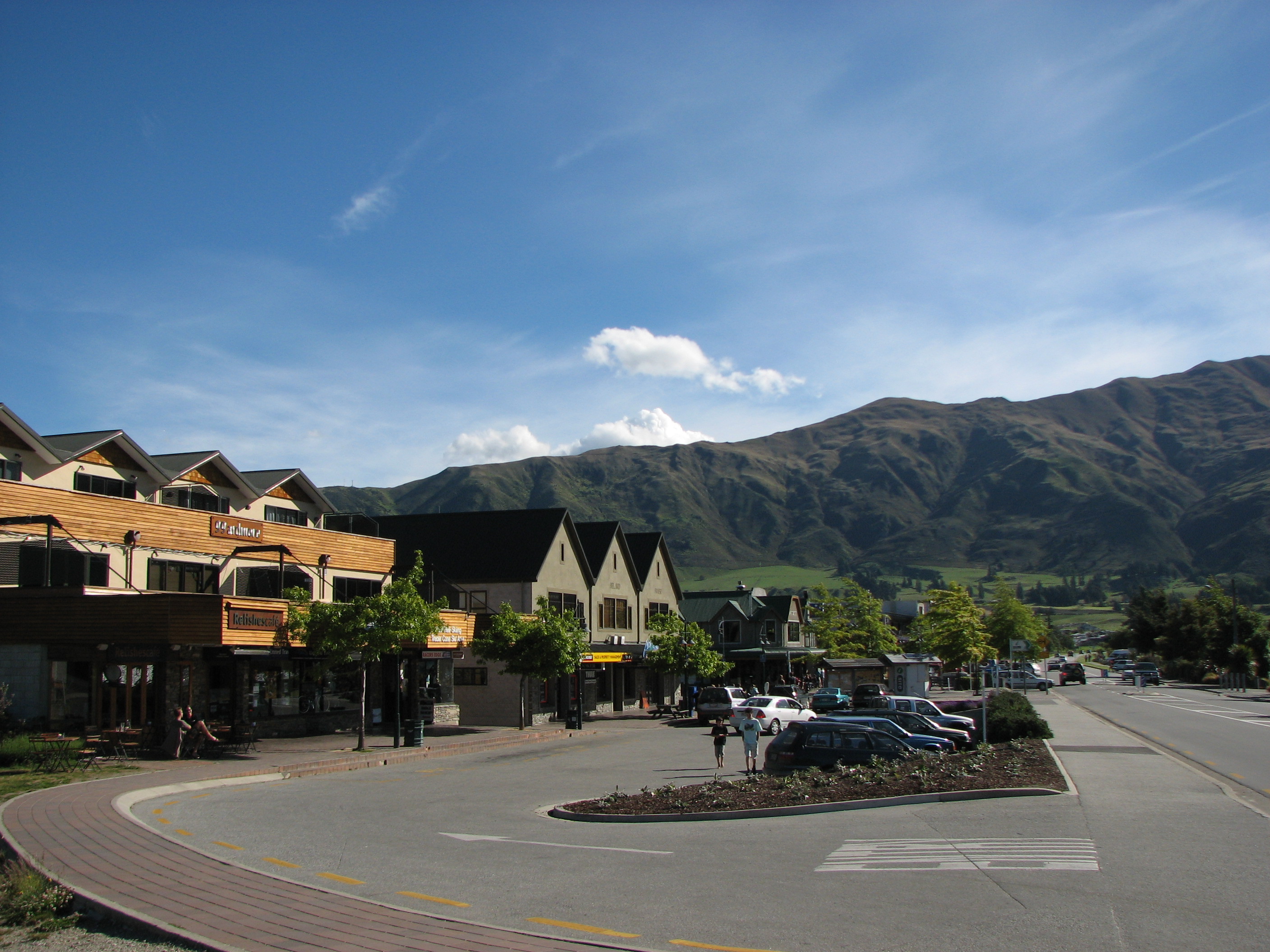
Wānaka (Māori pronunciation: [ˈwaːnaka])[3] is a popular ski and summer resort town in the Otago region of the South Island of New Zealand. At the southern end of Lake Wānaka, it is at the start of the Clutha River/Mata-Au and is the gateway to Mount Aspiring National Park.
Wānaka
Wānaka (Māori) | |
|---|---|
Town | |
 Wānaka east, with mountains in the background. | |
 | |
| Coordinates: 44°42′S 169°09′E | |
| Country | New Zealand |
| Region | Otago |
| Territorial authority | Queenstown Lakes District |
| Ward | Wānaka Ward |
| Government | |
| • Regional council | Otago Regional Council |
| • Local authority | Queenstown-Lakes District Council |
| • Community board | Wānaka Community Board[1] |
| Area | |
| • Total | 28.61 km2 (11.05 sq mi) |
| Elevation | 290 m (950 ft) |
| Population (June 2022)[2] | |
| • Total | 12,150 |
| • Density | 420/km2 (1,100/sq mi) |
| Time zone | UTC+12 (NZST) |
| • Summer (DST) | UTC+13 (NZDT) |
| Postcode | 9305 |
| Area code | 03 |
| Local iwi | Ngāi Tahu |
Wānaka is primarily a resort town with both summer and winter seasons. Its economy is based on the many outdoor opportunities this offers.
Historically, Māori visited the Wānaka area to hunt and fish in summer, or on their way to seek pounamu (greenstone) on the West Coast. Ngāi Tahu abandoned their seasonal camps after a raid by a North Island war party in 1836.
The current town was founded as Pembroke during the gold rush of the 19th century, and renamed to Wanaka in 1940.[4] Along with the rest of the Queenstown-Lakes District, Wānaka is growing rapidly, with the population increasing by 50% between 2005 and 2015.
Names

Wānaka is the South Island dialect pronunciation of wānanga, which means 'sacred knowledge or a place of learning'.[5] The New Zealand Gazetteer cites the meaning as "the lore of the tohunga or priest".[6]
While the name could also be a variation of Ō-Anake or Ō-Anaka, a proper name,[5] Ngāi Tahu's atlas Ka Huru Manu dismisses this variation as a simple spelling mistake.[7]
A Kāti Māmoe settlement at the site of modern Wānaka was Para karehu[8] or Parakārehu.[9] Take Kārara was a Kai Tahu kāinga nohoanga (settlement) at the southern end of Lake Wānaka, including Ruby Island.[9]
The town was named Wanaka when it was first surveyed in 1863, but renamed Pembroke within a month of the surveyor returning his books to Dunedin. Pembroke was the family name of the Hon Sydney Herbert,[10] a UK Cabinet Minister and member of the Canterbury Association.
The town's name reverted to Wanaka on 1 September 1940 to reduce confusion between the names of the town and the lake.[10] The official name of the lake was updated from Lake Wanaka to Lake Wānaka in 2019,[6] and the town to Wānaka in 2021.[11]
History
A Kāti Māmoe settlement at the site of modern Wānaka was named Para karehu.[8]
The area was invaded by the Ngāi Tahu in the early 18th century.[8] Ngai Tahu visited annually, seeking greenstone in the mountains above the Haast River and hunting eels and birds over summer, then returning to the east coast by descending the Mata-Au in reed boats called mōkihi.[12][13] Their settlement Take Kārara included a pā and a kāinga mahinga kai (food-gathering site) where pora ('Māori turnip'), mahetau, tuna (eels), and weka were gathered.[9] Eels and birds were gathered at a lagoon Manuhaea on the Hāwea side of The Neck, which also supported gardens of potato and turnips.[14]
Ngāi Tahu use of the land was ended by attacks by North Island tribes. In 1836, the Ngāti Tama chief Te Puoho led a 100-person war party, armed with muskets, down the West Coast and over the Haast Pass. They fell on the Ngāi Tahu encampment between Lake Wānaka and Lake Hāwea, capturing ten people and killing and eating two children.[15] Some of the Ngāi Tahu fled down the Waitaki river to the coast. Te Puoho took his captives over the Crown Range to Lake Wakatipu and thence to Southland where he was killed and his war party destroyed by the southern Ngāi Tahu leader Tuhawaiki.[16]
The first European to visit the area was Nathaniel Chalmers, who was guided inland by Chiefs Reko and Kaikoura in 1853.[17] Reko and Kaikoura showed Chalmers the rock bridge Whatatorere at Roaring Meg, which was the only place that the Kawarau River could be jumped over,[18] and returned him down the Clutha in a mōkihi reed boat.
European settlement began in the Upper Clutha River Valley in the 1850s, with the establishment of sheep stations by runholders. The first station was at Albert Town, the only place where settlers could ford the Clutha River. The present site of Wānaka was first surveyed in 1863.[4] Gold was discovered in the nearby Cardrona valley in 1862 with many joining the gold rush.[19] Settlement increased in Pembroke during the 1870s because of timber milling in the Matukituki Valley that used Lake Wānaka for transport.
Mass tourism began in 1867 when Theodore Russell opened the first hotel, and with the world's first sheepdog trials.[20] The first school in the area was opened in Albert Town in 1868.[19] and the Pembroke post office opened in 1873. The Pembroke school opened in 1880 which became the Wanaka District High School in 1940. In 1885 the Commercial Hotel opened in Pembroke and in 1887 the Wanaka Library opened on Ardmore Street. In 1922, the First Wānaka Hotel was destroyed by fire. The following year it was rebuilt as the Wanaka Public Hall. In 1940 Wānaka was connected to the national electricity grid.[19]
Wānaka proved a very popular tourist destination because of its borderline continental climate and easy access to snow and water.[21] With the development of Treble Cone (1968) and Cardrona ski fields (1980), Wānaka grew in popularity as a winter destination.[22]
Resource consent was approved for a film studio development in 2021. The film studio is expected to cost $280 million and will include up to 10 sound stages, an 11 hectare lake, an Italian village and replicas of parts of Venice, Paris and New York City.[23][24][25][26]
In late 2021, Wānaka became home to the smallest Countdown supermarket in New Zealand. It will provide increased competition in the supermarket trade for Wānaka.[27]
Geography
The town of Wānaka is situated at the southern end of Lake Wānaka, surrounded by mountains. To the southwest is the Crown Range and town of Queenstown (120 kilometres (75 mi)); to the north the Haast Pass cuts through the Southern Alps near Makarora. To the northeast are the towns of Omarama and Twizel. Very close to Lake Wānaka is Lake Hāwea, in a parallel glacial valley, which has a recently developed settlement of about 1,500 people. To the south of the town lies more of the Southern Alps. The Glendhu Bay motorpark is close to the town, leading into the Matukituki River valley which gives access to the Mount Aspiring National Park.
The centre of the town lies on flat land beside Roy's Bay. Parts of the town have expanded into the hills surrounding the centre and around Roy's Bay in both directions. The lakeside area of the town is prone to occasional flooding in spring when heavy rain and snowmelt can cause the lake to rise quickly, as in November 1999.[28][29]
Climate
Despite New Zealand's mostly oceanic climate, Wānaka is one of the few areas in the country to enjoy a semi-continental climate, with four distinct seasons. The weather is fairly dry, with spring (September–December) being the wettest season. Annual rainfall is 682 mm which is half the national average. Wānaka's summers are warm, with temperatures reaching the high 20s and an average summer maximum of 24 °C (75 °F). Wānaka's highest-ever temperature of 35.2 °C (95.4 °F) was recorded in January 2018.[30]
Winter can be extreme by New Zealand standards with temperature mostly in the single digits during the day time followed by cold and frosty nights and frequent snowfalls.
| Climate data for Wanaka | |||||||||||||
|---|---|---|---|---|---|---|---|---|---|---|---|---|---|
| Month | Jan | Feb | Mar | Apr | May | Jun | Jul | Aug | Sep | Oct | Nov | Dec | Year |
| Average high °C (°F) | 23.9 (75.0) |
23.4 (74.1) |
20.8 (69.4) |
17.3 (63.1) |
12.2 (54.0) |
8.4 (47.1) |
8.4 (47.1) |
11.0 (51.8) |
14.4 (57.9) |
16.8 (62.2) |
19.8 (67.6) |
21.9 (71.4) |
16.5 (61.7) |
| Average low °C (°F) | 10.8 (51.4) |
10.4 (50.7) |
8.4 (47.1) |
5.1 (41.2) |
1.6 (34.9) |
−0.9 (30.4) |
−1.2 (29.8) |
−0.2 (31.6) |
2.4 (36.3) |
5.0 (41.0) |
7.3 (45.1) |
9.6 (49.3) |
4.9 (40.7) |
| Average precipitation mm (inches) | 56.9 (2.24) |
50.2 (1.98) |
60.7 (2.39) |
56.4 (2.22) |
62.7 (2.47) |
54.5 (2.15) |
52.2 (2.06) |
52.8 (2.08) |
56.4 (2.22) |
63.1 (2.48) |
54.7 (2.15) |
51.9 (2.04) |
672.5 (26.48) |
| Mean monthly sunshine hours | 231.5 | 201.7 | 182.6 | 164.0 | 135.5 | 120.5 | 126.6 | 155.8 | 172.5 | 193.8 | 202.2 | 212.1 | 2,098.8 |
| Source: http://www.lakewanaka.co.nz/content/library/Weather_data.pdf | |||||||||||||
Demography
Wānaka covers 28.61 km2 (11.05 sq mi)[31] and had an estimated population of 12,150 as of June 2022,[2] with a population density of 425 people per km2. It is the country's 43rd-largest urban area and the fifth-largest urban area in Otago behind Dunedin, Queenstown, Mosgiel and Oamaru.
| Year | Pop. | ±% p.a. |
|---|---|---|
| 1996 | 2,600 | — |
| 2001 | 3,450 | +5.82% |
| 2006 | 5,043 | +7.89% |
| 2013 | 6,474 | +3.63% |
| 2018 | 9,552 | +8.09% |
| The boundaries for dates earlier than 2006 may differ Source: [32][33] | ||
Wānaka had a population of 9,552 at the 2018 New Zealand census, an increase of 3,078 people (47.5%) since the 2013 census, and an increase of 4,509 people (89.4%) since the 2006 census. There were 3,480 households. There were 4,719 males and 4,842 females, giving a sex ratio of 0.97 males per female, with 1,662 people (17.4%) aged under 15 years, 1,611 (16.9%) aged 15 to 29, 4,599 (48.1%) aged 30 to 64, and 1,695 (17.7%) aged 65 or older.
Ethnicities were 92.7% European/Pākehā, 5.2% Māori, 0.5% Pacific peoples, 4.5% Asian, and 2.5% other ethnicities (totals add to more than 100% since people could identify with multiple ethnicities).
The proportion of people born overseas was 28.9%, compared with 27.1% nationally.
Although some people objected to giving their religion, 60.7% had no religion, 31.2% were Christian, 1.0% were Hindu, 0.2% were Muslim, 0.5% were Buddhist and 1.7% had other religions.
Of those at least 15 years old, 2,340 (29.7%) people had a bachelor or higher degree, and 720 (9.1%) people had no formal qualifications. 1,641 people (20.8%) earned over $70,000 compared to 17.2% nationally. The employment status of those at least 15 was that 4,386 (55.6%) people were employed full-time, 1,323 (16.8%) were part-time, and 72 (0.9%) were unemployed.[33]
| Name | Area (km2) | Population | Density (per km2) | Households | Median age | Median income |
|---|---|---|---|---|---|---|
| Wanaka Waterfront | 3.89 | 2,121 | 549 | 765 | 42.4 years | $38,000[34] |
| Wanaka North | 7.77 | 2,412 | 210 | 816 | 35.2 years | $40,700[35] |
| Wanaka West | 4.42 | 1,725 | 390 | 669 | 45.8 years | $40,900[36] |
| Albert Town | 4.96 | 2,031 | 409 | 687 | 37.3 years | $41,700[37] |
| Wanaka Central | 7.56 | 1,263 | 167 | 543 | 46.3 years | $33,900[38] |
| New Zealand | 37.4 years | $31,800 |
Government
Wānaka is in the Waitaki electorate, represented by the New Zealand National Party's Jacqui Dean since 2005.[39]
Wānaka's local governments are the Queenstown-Lakes District Council[40] and the Otago Regional Council.[41]
Wānaka wine sub-region
The area around Wānaka is a formal sub-region of the Central Otago wine region with several top wineries and vineyards. As with other parts of the wine region, the main grape variety in the area is pinot noir.
Attractions

With its lake and mountain views, Wānaka has become a popular tourist resort, considered less commercialised than Queenstown.[42]
Wānaka boasts a growing number of restaurants, cafes and a diverse nightlife. Other attractions in the town include Puzzling World and the Paradiso Cinema. Puzzling World contains a maze, optical illusions and a leaning clocktower.[43] The Paradiso is a classic old cinema, with seating consisting of old couches and an in-theatre Morris Minor.[44] There are several wineries in the area. Just out of town next to the Wānaka Airport is the National Transport and Toy Museum.
In winter, Wānaka is an excellent place to see the Southern Lights.[45]
A number of mountains surrounding Wānaka can be climbed, including Roys Peak, Mount Iron, Mount Grand and the Pisa Range, all of which provide views of the surrounding area.
That Wanaka Tree – a willow growing just inside the lake – is a tourist attraction in its own right, featuring on many tourists' Instagram feeds.[46] The tree had its lower branches cut by vandals in 2020.[47]
Festivals

- The biennial Warbirds over Wanaka airshow has become a major attraction for national and international guests.
- Wanakafest[48]
- NZ Freeski Open
- The biennial New Zealand music Rippon Festival[49]
- Challenge Wanaka Triathlon Festival[50]
- The Festival of Colour[51] and Aspiring Conversations are two festivals organised by the Southern Lakes Arts Festival Trust. The Festival of Colour is a biennial multi disciplinary arts festival featuring theatre, music, dance and visual arts. Aspiring Conversations is an ideas festival. Both are timed for April in alternate years.
- Rhythm and Alps[52]
- The Wanaka agricultural and pastural show has been held since 1934 at the showgrounds in Wānaka. Thirty to forty thousand people are expected at the 85th edition in March 2022.[53]
- The Wanaka Rodeo is normally held each summer but was forced to cancel the 2022 edition due to "uncertainty around Covid-19 and new regulations".[54]
Film locations
The Wānaka region has been the setting for many international films, including The Lord of the Rings,[55] The Hobbit,[56] the Legend of S,[57] and A Wrinkle in Time.[58]
Summer

Wānaka is host to outdoor recreation and tourism activities with hiking, mountain biking, mountaineering, rock climbing, fishing, paragliding, kayaking, rafting, jetboating, and environmental activities. Wānaka has a sunny climate and serves as an access point to the highest New Zealand mountain outside of the Aoraki/Mount Cook region: Mount Aspiring/Tititea.
Mount Aspiring National Park is popular for mountaineering and hiking. Tourists enjoy day trips into the park and many tourists go hiking in the park for up to a week at a time. Parts of the Matukituki Valley on the road to the park are popular for rock climbing, and for day walks.
Lake Wānaka itself is popular for waterskiing, wakeboarding and sailing. This along with the local rivers provide many opportunities for fishing. There is a dedicated mountain biking area made by volunteers in a local pine forest.[59] Adjacent to the bike park is an 18-hole disc golf course. All the local ski resorts are open for mountain biking and hiking in the summer.

Winter

Wānaka has the broadest range of snow activity choices of any town in New Zealand. These include Treble Cone, Cardrona Alpine Resort and Snow Farm, some of New Zealand's premier commercial ski fields. Wānaka is the main accommodation provider for these resorts and so is very busy in high season (July–September).
Winter in Wānaka is also the home to a variety of winter sporting events including everything from the annual free Winter Games to The Merino Muster.
Treble Cone has good lift-accessed terrain and for this reason has become popular amongst visitors, 'ConeHeads'.[60] It also catches some of the better snow in the area, with its location and orientation getting more snow from NW storms.
Cardrona is more attractive to families and beginners, though an attempt has been made at the park riding population in competition with SnowPark.[61] Snowpark is a dedicated 100% artificial terrain park for advanced riders. Snow Farm is New Zealand's only commercial cross-country ski field.
Cardrona also hosts one of the few Olympic-sized halfpipes in the world and has been used for practice for Olympic competition.[62]
Amenities
- Wānaka amenities
 Wānaka Community Hub
 Skateboard park, Pembroke Park
 Mt Aspiring visitor centre


Swimming pool
The Wānaka Recreation Centre has a 25 metre lap pool, a 20 metre learners pool and hot pool for adults. It is located at 41 Sir Tim Wallis Drive.[63] The swimming complex was opened in 2018 and cost $12.8 million.[64]
Wānaka Community Hub
The Wānaka Community Hub is home to 25 community organisations. The building includes a hall, foyer and offices.[65] The build cost $3.8 million and was opened in October 2021.[66]
Library
The Wānaka Library is in Dunmore Street. As well as an extensive collection of books and ebooks, audiobooks and newspapers, the library provides Wifi, printing, copying and computer facilities.[67] After issues with freedom campers in 2016, signs in the Wānaka Library ask people not to bathe or wash dishes in the toilets.[68]
Golf course
The Wānaka golf course, located on Ballantye Road, was established in 1922. A further nine holes were added to the course in 1967 to make it an 18 hole golf course. The Wanaka Golf Club has around 950 members.[69][70]
Tititea/Mt Aspiring national park visitor centre
The Tititea/Mt Aspiring national park visitor centre is located on the corner of Ardmore St and Ballentyne Rd. It provides advice about walking and hiking in the national park and information about the huts, campsites, weather and heritage sites. There is also a small museum display of the history, fauna and flora of the national park within the visitor centre.[71]
Pembroke Park
Pembroke Park covers 10.5 hectares on the foreshore of Lake Wānaka. The majority of the park is grass fields, with a skate park and 136 carparks close to the town centre.
Originally known as "The Commonage", the park was surveyed in 1875 and 1880. A nine-hole golf course was established on the park by 1920, with barbed wire to keep the cows out. From 1940, the New Zealand Electricity Department held the park with the thought that Lake Wanaka might be used for hydro-electricity production. It was designated as a recreational reserve in 1971, managed by Lake County Council, (which later became the Queenstown Lakes District Council).[72]
The establishment of the parking lot in Pembroke Park in 2000 was controversial, as one of its management objectives is "to preserve in perpetuity Pembroke Park as a recreational area for the enjoyment of the people of Wanaka and visitors".[73]
Notable buildings
- Notable buildings
 St Columba's Anglican Church
 Chalmers' Cottage
 War Memorial
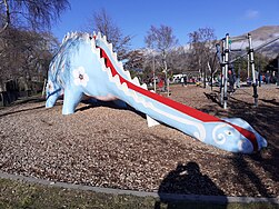 Dinosaur slide
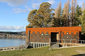 Watersports facility
 Wanaka Catholic Church


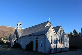
Saint Columba's Anglican Church
Saint Columba's was built in 1902 and completed in 1911. It is a category 2 historic place.[74]
Chalmers' cottage
Chalmers' cottage is a grade 2 listed building. It was built in the 1870s for Archibald Chalmers, who was a butcher based in Wānaka.[75]
Wānaka War Memorial
The Wānaka War Memorial commemorates the twenty seven soldiers from the area that died in World War I and the nine that died in World War II. It is located on Chalmers Street.[76][77]
Dinosaur slide
The dinosaur slide built by the Wānaka Jaycees in 1976 is a well known fixture at the lakefront playground in Wānaka.[78][79][80][81]
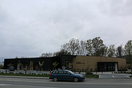
Wanaka watersports facility
Described as having a "richly textured and contoured façade [which] belies the tough functional requirements demanded by a project realised in a sensitive environmental zone", the Wanaka watersports facility was the winner of the 2020 Southern Architecture Awards.[82] It is used by the Wanaka Rowing Club, Wanaka Lake Swimmers and TriWanaka.[83] The facility gained resource consent in 2016 despite 744 submitters opposing the build.[84]
Holy Family Catholic Church
Holy Family Catholic Church was built in 2011 and its organic form was designed to allude to the mountains that surround it.[85] The church replaced the previous church in Brownston Street. It is located next to the Holy Family School.[86]
Education
Wānaka has four schools.
- Holy Family School is a state-integrated Catholic full primary (Year 1–8) school, and has 205 students. The school was established in 2006.
- Mount Aspiring College is a state Year 7–13 secondary school, and has 1194 students. The school was established in 1986 following the split of Wanaka Area School.
- Wanaka Primary School is a state contributing primary (Year 1–6) school and has 522 students. The school was established in 1986 following the split of Wanaka Area School and relocated to its current site in October 2010.
- Te Kura O Take Kārara is a state contributing primary school, and has 222 students.[87] The schools was established in 2020, providing capacity for more primary school aged children as Wānaka's population grows.[88]
All these schools are coeducational. Rolls are as of July 2022.[89]
Infrastructure and services
Transport
Wānaka is served by the Wānaka Airport as well as by roads over the Crown Range, through the Haast Pass/Tioripatea to the West Coast, to Mount Cook Village via the Lindis Pass to the north, and south through Cromwell by State Highway 6.
There are daily bus services to Christchurch, Dunedin, Queenstown, Invercargill and Greymouth.
During the early 20th century an unsuccessful proposal was made for the Otago Central Railway, then terminated at Cromwell, to be extended to Wānaka and onward to Lake Hāwea.[90] The main reason for NZR's reluctance was having to cross the Clutha River twice. A more direct route to Hāwea was planned but dropped due to cost.
Utilities
Aurora Energy operates the electricity distribution network in and around Wānaka. Electricity is fed from Transpower's national grid at Cromwell to Wānaka via twin 66,000-volt lines.[91][92]
Fresh water for the town is drawn from Lake Wānaka via two inlets and treated by chlorination prior to distribution. Since 2008, the water supply has had issues with Didymo "rock snot" algae entering the system and building up, clogging filters and household plumbing. The Queenstown-Lakes District Council planned to add protozoal treatment to the water supply in 2024.[93][94]
Notable people
- Tim Wallis, pilot
- Nico Porteous, New Zealand's youngest Olympic medallist
- Zoi Sadowski-Synnott, New Zealand's first winter Olympic gold medallist
References
- "Elected Members - QLDC". www.qldc.govt.nz. Queenstown Lakes District Council. Retrieved 11 July 2022.
- "Subnational population estimates (RC, SA2), by age and sex, at 30 June 1996-2022 (2022 boundaries)". Statistics New Zealand. Retrieved 25 October 2022. (regional councils); "Subnational population estimates (TA, SA2), by age and sex, at 30 June 1996-2022 (2022 boundaries)". Statistics New Zealand. Retrieved 25 October 2022. (territorial authorities); "Subnational population estimates (urban rural), by age and sex, at 30 June 1996-2022 (2022 boundaries)". Statistics New Zealand. Retrieved 25 October 2022. (urban areas)
- www.dynamo6.com. "wanaka - Te Aka Māori Dictionary". wanaka - Te Aka Māori Dictionary. Retrieved 1 April 2022.
- "The History of the Wanaka Region". Wanaka Tourism Centre. Retrieved 26 February 2019.
- "Wanaka". New Zealand History. Nga korero a ipurangi o Aotearoa. New Zealand Ministry for Culture and Heritage. Retrieved 7 November 2020.
- "Place name detail: Lake Wānaka". New Zealand Gazetteer. New Zealand Geographic Board. Retrieved 7 November 2020.
- "Lake Wānaka". Kā Huru Manu. Nga Rūnanga o Ngāi Tahu. Retrieved 19 April 2020.
- Taylor, W. A. "Lore and History of the South Island Maori". New Zealand Electronic Texts Collection. Retrieved 19 April 2020.
- "Lake Wānaka". Kā Huru Manu. Nga Rūnanga o Ngāi Tahu. Retrieved 19 September 2021.
- Dovey, Pam (13 June 2017). "Irish street names in Wanaka". Wanaka Sun. Wanaka Sun. Retrieved 31 July 2021.
- "Amendments—New Zealand Geographic Board Ngā Pou Taunaha o Aotearoa - 2021-ln3385 - New Zealand Gazette". gazette.govt.nz. Retrieved 2 September 2021.
- Malcolm McKinnon. "Otago region - Māori history and whaling". Te Ara - the Encyclopedia of New Zealand. Retrieved 11 July 2017.
- Hoturoa Barclay-Kerr. "Waka – canoes - Other types of waka". Te Ara - the Encyclopedia of New Zealand. Retrieved 11 July 2017.
- "Protecting Ngai Tahu History — Cultural Mapping Project — Te Rūnanga o Ngāi Tahu". www.kahurumanu.co.nz. Retrieved 17 July 2022.
- S Percy Smith (1910). History and Traditions of the Maoris of the West Coast North Island of New Zealand Prior to 1840. New Plymouth: Polynesian Society.
- Atholl Anderson (1990). "Te Puoho-o-te-rangi". Te Ara - the Encyclopedia of New Zealand. Vol. 1. Retrieved 11 July 2017.
- Jock Phillips. "European exploration - Otago and Southland". Te Ara - the Encyclopedia of New Zealand. Retrieved 11 July 2017.
- Janet Stephenson, Heather Bauchop, and Peter Petchey (2004). Bannockburn Heritage Landscape Study (PDF). p. 29.
{{cite book}}: CS1 maint: multiple names: authors list (link) - "Timeline | UCHRS - Upper Clutha Historical Records Society". www.uppercluthahistory.org. Retrieved 30 September 2021.
- "World First Recorded Trial". Marlborough, New Zealand: DogFind. Archived from the original on 16 November 2010.
- "Wanaka Information Guide". Archived from the original on 3 October 2000.
- Taonga, New Zealand Ministry for Culture and Heritage Te Manatu. "Wānaka district". teara.govt.nz. Retrieved 30 September 2021.
- "Resource consent approved for massive Wanaka film studio development". NZ Herald. Retrieved 16 December 2021.
- "Massive film set unveiled for Wanaka includes replicas of New York, Venice and Paris". NZ Herald. Retrieved 16 December 2021.
- Cook, Marjorie (11 November 2021). "Decision on multimillion-dollar film studio next month". Otago Daily Times Online News. Retrieved 16 December 2021.
- "Hard work just beginning for directors of new $280m Wānaka film studio". Stuff. 8 December 2021. Retrieved 16 December 2021.
- Cook, Marjorie (24 December 2021). "Country's smallest Countdown opens in Wanaka". Otago Daily Times Online News. Retrieved 28 December 2021.
- "Archived copy" (PDF). www.civildefence.govt.nz:80. Archived from the original (PDF) on 30 August 2003. Retrieved 17 January 2022.
{{cite web}}: CS1 maint: archived copy as title (link) - "Archived copy" (PDF). www.qldc.govt.nz. Archived from the original (PDF) on 27 September 2007. Retrieved 17 January 2022.
{{cite web}}: CS1 maint: archived copy as title (link) - Stuff (28 January 2018). "Hottest ever recorded temperature in Wanaka".
- "ArcGIS Web Application". statsnz.maps.arcgis.com. Retrieved 12 December 2021.
- "Infoshare; Group: Population Estimates - DPE; Table: Estimated Resident Population for Urban Areas, at 30 June (1996+) (Annual-Jun)". Statistics New Zealand. Retrieved 22 October 2019.
- "Statistical area 1 dataset for 2018 Census". Statistics New Zealand. March 2020. Wanaka Waterfront (346600), Wanaka North (346700), Wanaka West (346800), Albert Town (346900) and Wanaka Central (347000).
- 2018 Census place summary: Wanaka Waterfront
- 2018 Census place summary: Wanaka North
- 2018 Census place summary: Wanaka West
- 2018 Census place summary: Albert Town
- 2018 Census place summary: Wanaka Central
- "Official Count Results - Waitaki". Electionresults.govt.nz. 22 November 2008. Retrieved 21 January 2017.
- "Queenstown-Lakes District Council".
- "Otago Regional Council".
- "Wanaka and Treble Cone, New Zealand". www.bestwestern.co.nz:80. Archived from the original on 17 December 2004. Retrieved 17 January 2022.
- "Welcome to Wanaka's Wonderful World of Weirdness!". Puzzling World. Retrieved 21 January 2017.
- "Cinema Paradiso | Home". Paradiso.net.nz. Retrieved 21 January 2017.
- "Severe geomagnetic storm lights up sky". Stuff.co.nz. 18 March 2015. Retrieved 21 January 2017.
- "Wanaka's famous Instagram tree attacked with a saw". The Guardian. Retrieved 18 April 2020.
- Marcus, Lilit (20 March 2020). "New Zealand's most famous tree, 'That Wanaka Tree,' vandalized". CNN Travel. CNN. Retrieved 18 April 2020.
- "Wanakafest 2015 | Wanaka family festival events & live music!". Wanakafest.co.nz. Retrieved 21 January 2017.
- "Rippon Open Air Festival 2014". Ripponfestival.co.nz. 1 February 2014. Retrieved 21 January 2017.
- "Challenge Wanaka, Lake Wanaka, New Zealand". Challenge-wanaka.com. 19 December 2016. Retrieved 21 January 2017.
- "Festival of Colour". Festival of Colour. Retrieved 21 January 2017.
- "Rhythm & Alps - New Years Music Festival Wanaka, New Zealand". Rhythmandalps.co.nz. Retrieved 21 January 2017.
- "Wanaka A&P Show". www.wanakashow.co.nz. Retrieved 8 November 2021.
- "Wanaka Rodeo joins Covid cancellation list". Otago Daily Times Online News. 2 December 2021. Retrieved 28 December 2021.
- "The Lord of the Rings Location: Tarras & Wanaka". Jasons. Retrieved 19 March 2020.
- "The Hobbit Trilogy Filming Locations". 100% Pure New Zealand. Retrieved 19 March 2020.
- Miller, Tim. "Chinese fantasy filming in Wanaka". Otago Daily Times. Retrieved 27 January 2018.
- Cook, Marjorie. "Witherspoon, Winfrey and Kaling in Wanaka and Lake Hawea". Stuff. Retrieved 19 March 2020.
- "Lake Wanaka Cycling". 9 June 2008. Archived from the original on 9 June 2008.
- "Treble Cone, Wanaka, New Zealand". 14 August 2006. Archived from the original on 14 August 2006.
- "Welcome | Cardrona NZ". Cardrona.com. 3 April 2016. Retrieved 21 January 2017.
- "Snowboarding at the Cardrona Halfpipe - Video". The New York Times. 40.755978;-73.990396. Retrieved 21 January 2017.
{{cite news}}: CS1 maint: location (link) - Interactive (https://www.nvinteractive.com), N. V. "Wānaka Recreation Centre". www.qldc.govt.nz. Retrieved 29 September 2021.
- "Dive into the new Wanaka pool!". Otago Daily Times Online News. 3 July 2018. Retrieved 29 September 2021.
- "Wanaka Community Hub - Condon Scott Architects - Wanaka & Queenstown". condonscott.nz. Retrieved 19 October 2021.
- Price, Mark (4 November 2019). "Wanaka Community Hub opens". Otago Daily Times Online News. Retrieved 19 October 2021.
- Interactive (https://www.nvinteractive.com), N. V. "Wānaka Library". codc-qldc.govt.nz. Retrieved 29 September 2021.
- "Wanaka Library evicts abusive Frenchman with big bag". Stuff. 1 April 2016. Retrieved 29 September 2021.
- "Wanaka Golf Home". Wanaka Golf Club. Retrieved 29 September 2021.
- "Wanaka Golf Club - Top 100 Golf Courses of New Zealand". www.top100golfcourses.com. Retrieved 29 September 2021.
- "DOC Tititea / Mt Aspiring National Park Visitor Centre | Visitor Information Centres in Wanaka, New Zealand". www.newzealand.com. Retrieved 29 September 2021.
- "History". Friends of Pembroke Park. Retrieved 19 October 2021.
- "People's fight for park: the history". Otago Daily Times Online News. 14 February 2013. Retrieved 19 October 2021.
- "Search the List | St Columba's Anglican Church | Heritage New Zealand". www.heritage.org.nz. Retrieved 24 July 2021.
- "Search the List | Chalmers' Cottage (Former) | Heritage New Zealand". www.heritage.org.nz. Retrieved 24 July 2021.
- "Photo Point 4 - Wanaka War Memorial". Wanaka Tourism. Retrieved 14 October 2021.
- "Wanaka war memorial". nzhistory.govt.nz. Retrieved 14 October 2021.
- Editor, Online (30 December 2011). "Dinosaur's durability delights designer". Otago Daily Times Online News. Retrieved 21 August 2021.
{{cite web}}:|last=has generic name (help) - "Kids On Board Roys Bay Recreational Reserve (Dinosaur Park), Wanaka | Kids On Board". Kids On Board | Child Friendly Activity Reviews NZ. 30 August 2016. Retrieved 21 August 2021.
- "Wanaka Dinosaur Park". Wanaka Tourism. Retrieved 21 August 2021.
- "On Magazine – Go play outside: Wanaka Playground Review". Retrieved 21 August 2021.
- Architects (www.nzia.co.nz), NZ Institute of. "Wanaka Watersports Facility". NZ Institute of Architects (www.nzia.co.nz). Retrieved 26 September 2021.
- Henderson, Simon. "Wanaka Watersports Facility nears completion". Retrieved 26 September 2021.
- "Approval for controversial Wanaka Watersports Facility". Stuff. 26 July 2016. Retrieved 26 September 2021.
- "Wanaka Catholic Church / Sarah Scott Architects Ltd". ArchDaily. 19 September 2013. Retrieved 19 October 2021.
- "Fish-inspired building 'evolving'". Stuff. 17 September 2009. Retrieved 19 October 2021.
- Counts, Education. "Ministry of Education - Education Counts". www.educationcounts.govt.nz. Retrieved 28 April 2020.
- "National Growth Plan 2019" (PDF). Ministry of Education. 28 April 2020.
- "New Zealand Schools Directory". New Zealand Ministry of Education. Retrieved 19 August 2022.
- Over the Garden Wall : The Story of the Otago Central Railway, James Albert Dangerfield, George West Emerson; New Zealand Railway and Locomotive Society (Otago Branch), 1967
- "About | Aurora Energy Limited". www.auroraenergy.co.nz. Retrieved 6 February 2022.
- "Asset Management Plan" (PDF). Aurora Energy. 12 June 2020. Retrieved 6 February 2022.
- "Supply and treatment". www.qldc.govt.nz. Retrieved 6 February 2022.
- McKenzie-McLean, Jo (24 November 2016). "Bores or filter system explored as 'interim solution' to Queenstown's algae water woes". Stuff. Retrieved 6 February 2022.
External links
 Definitions from Wiktionary
 Media from Commons
 Travel information from Wikivoyage
 Data from Wikidata
Authority control | |
|---|---|
| General | |
| National libraries | |
На других языках
[de] Wanaka
Wanaka, in Māori-schreibweise: Wānaka, ist eine kleine Stadt im Queenstown-Lakes District der Region Otago auf der Südinsel von Neuseeland.- [en] Wānaka
Другой контент может иметь иную лицензию. Перед использованием материалов сайта WikiSort.org внимательно изучите правила лицензирования конкретных элементов наполнения сайта.
WikiSort.org - проект по пересортировке и дополнению контента Википедии