world.wikisort.org - Netherlands
Westervelde is a village in the Netherlands and part of the Noordenveld municipality in Drenthe.
Westervelde | |
|---|---|
Village | |
 Huis te Westervelde | |
 Westervelde Location in province of Drenthe in the Netherlands  Westervelde Westervelde (Netherlands) | |
| Coordinates: 53°3′12″N 6°26′32″E | |
| Country | Netherlands |
| Province | Drenthe |
| Municipality | Noordenveld |
| Area | |
| • Total | 0.59 km2 (0.23 sq mi) |
| Elevation | 9 m (30 ft) |
| Population (2021)[1] | |
| • Total | 150 |
| • Density | 250/km2 (660/sq mi) |
| Time zone | UTC+1 (CET) |
| • Summer (DST) | UTC+2 (CEST) |
| Postal code | 9337 |
| Dialing code | 0592 |
History
Westervelde is an esdorp which developed in the middle ages on higher grounds. The communal pasture of the village is triangular.[3] It was first mentioned in 1484 as Westeruelde. The name means western field.[4] It was established as a daughter settlement of Norg.[3]
Huis te Westervelde or Tonckensborg dates from the 17th century, but has been extensively rebuilt in the late 18th century. Since 1709, it was home to the Tonckens family.[3] It is currently in use as an hotel.[5] Other nobility also built estates in Westervelde.[5] The whole village has been designated a protected area.[3]
Westervelde is the site of a neolithic burial site called hunebed (Dolmen) D2 which is located near the Norgerholt forest. Originally, it had four covering stones, but only two remain.[6] The area around Westervelde is characterised by large forests and agricultural fields, and mainly has a recreational use.[5]
Gallery
 Dolmen (hunebed) D2
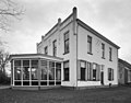 De Jufferen Lunsingh
 Shepherd with sheep (before 1942)
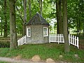 Garden cupola


References
- "Kerncijfers wijken en buurten 2021". Central Bureau of Statistics. Retrieved 9 March 2022.
- "Postcodetool for 9337PA". Actueel Hoogtebestand Nederland (in Dutch). Het Waterschapshuis. Retrieved 9 March 2022.
- Ronald Stenvert (2001). Westervelde (in Dutch). Zwolle: Waanders. p. 207. ISBN 90 400 9454 3. Retrieved 9 March 2022.
- "Westervelde". Etymologiebank (in Dutch). Retrieved 9 March 2022.
- "Westervelde". Plaatsengids (in Dutch). Retrieved 9 March 2022.
- "D02". Hunebedden (in Dutch). Retrieved 9 March 2022.
This Drenthe location article is a stub. You can help Wikipedia by expanding it. |
Другой контент может иметь иную лицензию. Перед использованием материалов сайта WikiSort.org внимательно изучите правила лицензирования конкретных элементов наполнения сайта.
WikiSort.org - проект по пересортировке и дополнению контента Википедии