world.wikisort.org - Netherlands
Roderwolde is a village in the Netherlands and is part of the Noordenveld municipality in Drenthe.
Roderwolde | |
|---|---|
Village | |
 Main street of Roderwolde | |
 Roderwolde Location in province of Drenthe in the Netherlands  Roderwolde Roderwolde (Netherlands) | |
| Coordinates: 53°10′6″N 6°28′11″E | |
| Country | Netherlands |
| Province | Drenthe |
| Municipality | Noordenveld |
| Area | |
| • Total | 0.67 km2 (0.26 sq mi) |
| Elevation | 1 m (3 ft) |
| Population (2021)[1] | |
| • Total | 305 |
| • Density | 460/km2 (1,200/sq mi) |
| Time zone | UTC+1 (CET) |
| • Summer (DST) | UTC+2 (CEST) |
| Postal code | 9315 |
| Dialing code | 050 |
History
Roderwolde is a road village which was established during the early middle ages for the excavation of peat.[3] It was first mentioned in 1139 as Roterwolde and means "forest near Roden".[4] Due to settling of the soil, most of the village was relocated to higher grounds in the south. Sandebuur is a remnant of the earliest settlement.[3] The first church was built in the 12th century.[4] The current church dates from 1831.[3] In 1840, Roderwolde was home 142 people.[5]
In 1852, Woldzigt, a corn and oil windmill, was built in Roderwolde. It was restored to working order in 1973–74.[6][3]
Roderwolde used to have a little harbour which was removed in the 1960s. In 2016, Schippershoaven, a new harbour, opened for recreational boating.[7]
Gallery
 The Jacobskerk of Roderwilde
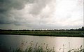 Nature near Roderwolde
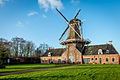 Windmill Woldzigt
 A stork in Roderwolde


References
- "Kerncijfers wijken en buurten 2021". Central Bureau of Statistics. Retrieved 10 March 2022.
- "Postcodetool for 9315PA". Actueel Hoogtebestand Nederland (in Dutch). Het Waterschapshuis. Retrieved 10 March 2022.
- Ronald Stenvert (2001). Roderwolde (in Dutch). Zwolle: Waanders. p. 171. ISBN 90 400 9454 3. Retrieved 10 March 2022.
- "Roderwolde - (geografische naam)". Etymologiebank (in Dutch). Retrieved 10 March 2022.
- "Roderwolde". Plaatsengids (in Dutch). Retrieved 10 March 2022.
- "Woldzigt". Molendatabase (in Dutch). Retrieved 10 March 2022.
- "Haven(tje) van Roderwolde". Drenthe.nl (in Dutch). Retrieved 10 March 2022.
This Drenthe location article is a stub. You can help Wikipedia by expanding it. |
Другой контент может иметь иную лицензию. Перед использованием материалов сайта WikiSort.org внимательно изучите правила лицензирования конкретных элементов наполнения сайта.
WikiSort.org - проект по пересортировке и дополнению контента Википедии