world.wikisort.org - Netherlands
Vlissingen (Dutch: [ˈvlɪsɪŋə(n)] (![]() listen); Zeelandic: Vlissienge), historically known in English as Flushing, is a municipality and a city in the southwestern Netherlands on the former island of Walcheren. With its strategic location between the Scheldt river and the North Sea, Vlissingen has been an important harbour for centuries. It was granted city rights in 1315. In the 17th century Vlissingen was a main harbour for ships of the Dutch East India Company (VOC). It is also known as the birthplace of Admiral Michiel de Ruyter.
listen); Zeelandic: Vlissienge), historically known in English as Flushing, is a municipality and a city in the southwestern Netherlands on the former island of Walcheren. With its strategic location between the Scheldt river and the North Sea, Vlissingen has been an important harbour for centuries. It was granted city rights in 1315. In the 17th century Vlissingen was a main harbour for ships of the Dutch East India Company (VOC). It is also known as the birthplace of Admiral Michiel de Ruyter.
Vlissingen
Vliessinge (Zeeuws) Flushing | |
|---|---|
Municipality | |
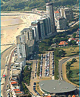
 Clockwise from top left: Coastline skyscraper, harbour, museum, residential tower and boulevard with beach | |
 Flag  Coat of arms | |
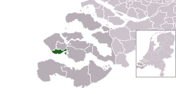 Location in Zeeland | |
 Vlissingen Location within the Netherlands  Vlissingen Location within Europe | |
| Coordinates: 51°27′N 3°34′E | |
| Country | Netherlands |
| Province | Zeeland |
| Boroughs | 8 Districts
|
| Government | |
| • Body | Municipal council |
| • Mayor | Bas van den Tillaar (CDA) |
| Area | |
| • Total | 344.84 km2 (133.14 sq mi) |
| • Land | 34.31 km2 (13.25 sq mi) |
| • Water | 310.53 km2 (119.90 sq mi) |
| Elevation | 1 m (3 ft) |
| Population (January 2019)[4] | |
| • Total | 44,371 |
| • Density | 1,293/km2 (3,350/sq mi) |
| Demonym | Vlissinger |
| Time zone | UTC+1 (CET) |
| • Summer (DST) | UTC+2 (CEST) |
| Postcode | 4380–4389 |
| Area code | 0118 |
| Website | vlissingen |
Vlissingen is mainly noted for the yards on the Scheldt where most of the ships of the Royal Netherlands Navy (Koninklijke Marine) are built.
Geography
The municipality of Vlissingen consists of the following places:
- City: Vlissingen
- Villages: Oost-Souburg, Ritthem, and West-Souburg
- Hamlet: Groot-Abeele
History


The fishermen's hamlet that came into existence at the estuary of the Schelde around AD 620 has grown over its 1,400-year history into the third-most important port of the Netherlands. The Counts of Holland, Flanders, and Zeeland had the first harbours dug. Over the centuries, Vlissingen developed into a hub for fishing, especially the herring fishery, commerce, privateering and the slave trade. Under the Treaty of Nonsuch in 1585, English garrisons were stationed here and at Brill to keep these ports out of Spanish hands. The towns were sold back to the Dutch in 1616.[5] During the heyday of the Dutch Golden Age, ships from Vlissingen set sail for the various outposts of the Dutch colonial empire and contributed to the world power of The Seven Provinces.
The history of Vlissingen was also marked by invasion, oppression and bombardments. Because of its strategic position at the mouth of the Schelde, the most important passageway to Antwerp, it has attracted the interest, at one time or another, of the British, the French, the Germans and the Spanish. Floods have also been a constant threat. Vlissingen declined during the 18th century. The Napoleonic Wars were particularly disastrous. After 1870, the economy revived after the construction of new docks and the Walcheren canal, the arrival of the railway and the establishment of the shipyard called De Schelde. The Second World War interrupted this growth. The city was heavily damaged by shelling and inundation but was captured and liberated by British Commandos of 4th Special Service Brigade on 3 November 1944.
The city was rebuilt after the war. In the 1960s, the seaport and industrial area of Vlissingen-Oost developed and flourished. Now this area is the economic driving force behind central Zeeland, generating many thousands of jobs. Nowadays approx. 50,000 ships annually from all corners of the world pass through the Schelde.[6]
Name
Etymology
The derivation of the name Vlissingen is unclear, though most scholars relate the name to the word fles ("bottle") in one way or another.
According to one story, when saint Willibrord landed in Vlissingen with a bottle in the 7th century, he shared its contents with the beggars he found there while trying to convert them. A miracle occurred, typical of hagiography, when the contents of the bottle did not diminish. When the bishop realised the beggars did not want to listen to his words, he gave them his bottle. After that, he supposedly called the city Flessinghe.
Another source states that the name had its origins in an old ferry-service house, on which a bottle was attached by way of a sign. The monk Jacob van Dreischor, who visited the city in 967, then apparently called the ferry-house het veer aan de Flesse ("the ferry at the Bottle"). Because many cities in the region later received the appendix -inge, the name, according to this etymology, evolved to Vles-inge.
According to another source, the name was derived from the Danish word Vles, which means "tides".
The eastern cape of Novaya Zemlya, Cape Flissingsky was named after the city in 1596 by Willem Barentsz.
Historical English name "Flushing"
Vlissingen was historically called "Flushing" in English. In the 17th century, Vlissingen was important enough for English speakers that it had acquired an anglicised name. For example, Samuel Pepys referred to the town as "Flushing" in his diaries. In 1673, Sir William Temple referred to Vlissingen as "Flushing" once and "Flussingue" twice in his book about the Netherlands.[7] Some English writers in the Netherlands also used the Dutch name.
The American settlement of Flushing, originally a Dutch colonial village founded in 1645 and now part of Queens, New York City, was first called Vlissingen after the town in the Netherlands. The English settlers who also came to live in the village[8] shortened the name to "Vlissing" by 1657 and then began to call it by its English name "Flushing." The Anglicisation of "Vlissingen" into "Flushing" did not occur after the conquest of New Netherland, but in England well before then. This village was the site of the Flushing Remonstrance.
The village of Flushing in Cornwall was also named after Vlissingen. Originally named Nankersey, the village was given its name by Dutch engineers from Vlissingen in the Netherlands who built the three main quays in the village. Michigan and Ohio in the US have villages called Flushing as well.
Gallery
 The Market building at Beursplein (Marketsquare)
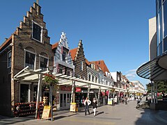 Part of the shopping street Walstraat in 2010
 Statue Michiel de Ruyter
 Windmill: de Oranjemolen
 View to a port and a street (de Nieuwendijk)


Topography

Topographic map of Vlissingen (city), Sept. 2014
Climate
Vlissingen has a temperate oceanic climate (Köppen climate classification Cfb) that is milder than the rest of the Netherlands due to its more southern location on the coast.[9] It is approximately 1.5 degrees Celsius warmer annually than Groningen in the northeast. It is also one of the sunniest cities in the Netherlands, receiving approximately 180 more sunshine hours than Maastricht in the southeast. Its all-time record is 36.8 °C (98.2 °F) set on 27 July 2018 and −18.9 °C (−2.0 °F) on 21 February 1956.
| Climate data for Vlissingen (1991−2020 normals, extremes 1906−present) | |||||||||||||
|---|---|---|---|---|---|---|---|---|---|---|---|---|---|
| Month | Jan | Feb | Mar | Apr | May | Jun | Jul | Aug | Sep | Oct | Nov | Dec | Year |
| Record high °C (°F) | 14.2 (57.6) |
16.9 (62.4) |
21.1 (70.0) |
29.9 (85.8) |
34.9 (94.8) |
34.6 (94.3) |
37.3 (99.1) |
34.2 (93.6) |
33.2 (91.8) |
25.0 (77.0) |
18.3 (64.9) |
14.8 (58.6) |
37.3 (99.1) |
| Average high °C (°F) | 6.4 (43.5) |
6.8 (44.2) |
9.6 (49.3) |
13.3 (55.9) |
16.8 (62.2) |
19.6 (67.3) |
21.8 (71.2) |
22.0 (71.6) |
19.0 (66.2) |
14.8 (58.6) |
10.4 (50.7) |
7.2 (45.0) |
14.0 (57.2) |
| Daily mean °C (°F) | 4.5 (40.1) |
4.6 (40.3) |
6.8 (44.2) |
9.8 (49.6) |
13.3 (55.9) |
16.1 (61.0) |
18.4 (65.1) |
18.6 (65.5) |
16.1 (61.0) |
12.4 (54.3) |
8.5 (47.3) |
5.4 (41.7) |
11.2 (52.2) |
| Average low °C (°F) | 2.6 (36.7) |
2.6 (36.7) |
4.4 (39.9) |
6.9 (44.4) |
10.2 (50.4) |
13.0 (55.4) |
15.4 (59.7) |
15.6 (60.1) |
13.4 (56.1) |
10.1 (50.2) |
6.5 (43.7) |
3.5 (38.3) |
8.7 (47.7) |
| Record low °C (°F) | −15.3 (4.5) |
−18.9 (−2.0) |
−6.5 (20.3) |
−3.3 (26.1) |
0.8 (33.4) |
5.0 (41.0) |
8.3 (46.9) |
8.9 (48.0) |
3.9 (39.0) |
−1.9 (28.6) |
−7.5 (18.5) |
−13.5 (7.7) |
−18.9 (−2.0) |
| Average precipitation mm (inches) | 58.9 (2.32) |
52.8 (2.08) |
44.6 (1.76) |
35.0 (1.38) |
49.4 (1.94) |
62.0 (2.44) |
72.4 (2.85) |
81.8 (3.22) |
73.6 (2.90) |
73.8 (2.91) |
78.9 (3.11) |
75.7 (2.98) |
758.9 (29.88) |
| Average precipitation days (≥ 1 mm) | 12 | 9 | 11 | 9 | 10 | 10 | 9 | 10 | 11 | 12 | 13 | 13 | 128 |
| Average snowy days | 5 | 5 | 2 | 1 | 0 | 0 | 0 | 0 | 0 | 0 | 2 | 3 | 18 |
| Average relative humidity (%) | 86.9 | 85.1 | 82.1 | 77.1 | 76.8 | 77.4 | 77.4 | 77.5 | 79.6 | 83.3 | 86.9 | 87.4 | 81.5 |
| Mean monthly sunshine hours | 76.3 | 99.0 | 155.5 | 207.5 | 233.8 | 230.1 | 232.1 | 217.0 | 170.8 | 127.0 | 77.4 | 62.5 | 1,889 |
| Percent possible sunshine | 29.1 | 35.0 | 42.2 | 49.7 | 48.4 | 46.4 | 46.5 | 47.9 | 44.9 | 38.2 | 28.8 | 25.4 | 40.2 |
| Source 1: Royal Netherlands Meteorological Institute (1991–2020 normals, precipitation days normals for 1981–2010, snowy days normals for 1971–2000)[10][11] | |||||||||||||
| Source 2: Royal Netherlands Meteorological Institute[12] | |||||||||||||
| Climate data for Vlissingen | |||||||||||||
|---|---|---|---|---|---|---|---|---|---|---|---|---|---|
| Month | Jan | Feb | Mar | Apr | May | Jun | Jul | Aug | Sep | Oct | Nov | Dec | Year |
| Average sea temperature °C | 6.6 |
5.8 |
6.9 |
9.5 |
13.2 |
16.6 |
19.0 |
20.0 |
18.4 |
15.3 |
11.4 |
8.0 |
12.6 |
| Mean daily daylight hours | 8.0 | 10.0 | 12.0 | 14.0 | 16.0 | 17.0 | 16.0 | 15.0 | 13.0 | 11.0 | 9.0 | 8.0 | 12.4 |
| Average Ultraviolet index | 0 | 1 | 2 | 4 | 5 | 7 | 7 | 6 | 4 | 3 | 1 | 1 | 3.5 |
| Source: Weather Atlas[13] | |||||||||||||
Notable people

Pageantry
The Arts
- Petrus Cunaeus (1586–1638) Dutch Christian scholar, wrote The Hebrew Republic
- Adriaan Dortsman (1635–1682) a Dutch Golden Age architect of Amsterdam
- Betje Wolff (1738–1804) a Dutch novelist [14]
- Jacobus Bellamy (1757–1786) a Dutch poet
- Paula de Waart (1876–1938) a Dutch film actress [15]
- Helene Koppejan (1927-1998) a Dutch astrologer and entrepreneur
- Hans Verhagen (born 1939) a Dutch journalist, poet, painter and filmmaker
- Jean-Pierre Guiran (born 1957) accordion player with Accordéon Mélancolique
- Arendo Joustra (born 1957) a Dutch writer and journalist
Science

- Jan Bekker Teerlink (1759–1832) a Dutch plant and seed collector and winemaker
- Martin Kalbfleisch (1804–1873) a Dutch pioneer in the chemical industry and a US politician [16]
- Egbert Cornelis Nicolaas van Hoepen (1884–1966) a Dutch paleontologist
- Prof. Bonno Thoden van Velzen (born 1933) a Dutch anthropologist
- Maarten de Rijke (born 1961) a Dutch computer scientist, worked on modal logic and knowledge representation
Admirals
- Joos de Moor (1548 or 1558 – 1618) a Dutch Vice Admiral of Zeeland
- Laurens Alteras (died 1622) a Dutch (Zealandic) vice admiral
- Joost Banckert (c.1597–1647) a Dutch Vice Admiral
- Johan Evertsen (1600–1666) a Dutch admiral
- Mårten Anckarhielm (died 1657) a Dutch admiral who entered into Swedish service
- Abraham Crijnssen (died 1669) a Dutch naval commander
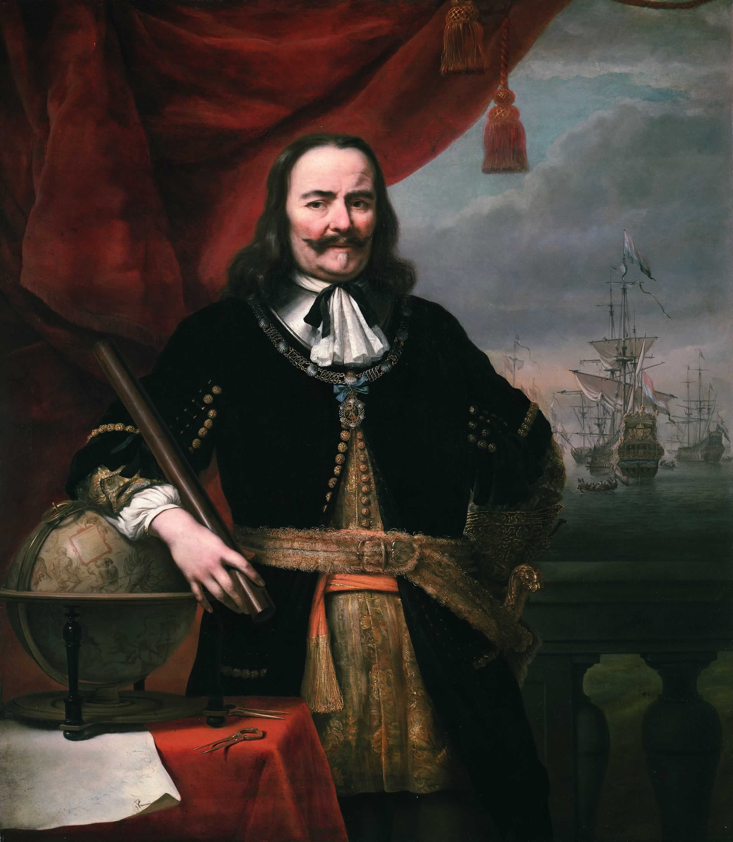
- Michiel de Ruyter (1607–1676) a widely celebrated Dutch admiral
- Cornelis Evertsen the Elder (1610–1666) a Dutch admiral.
- Adriaen Banckert (c.1615–1684) a Dutch admiral
- Cornelis Evertsen the Younger (1628–1679) a Dutch Admiral
- Cornelis Evertsen the Youngest (1642–1706) a Dutch admiral
- Engel de Ruyter (1649–1683) a Dutch vice-admiral
Other maritime travellers

- Willem Verstegen (c.1612–1659) a merchant in service of the Dutch East India Company and chief trader of factory
- Pieter Ita (active 1620s) a Dutch privateer and an admiral in the Dutch West India Company
- Nicholas van Hoorn (c.1635–1683) a merchant sailor, privateer and pirate [17]
- Jasper Danckaerts (1639–1702/1704) the founder of a colony of Labadists in Maryland
- Jan Erasmus Reyning (1640–1697) a Dutch pirate, privateer and naval officer
- Samuel van der Putte (1690–1745) a Dutch explorer, linguist and naturalist; journeyed in Asia, especially to Tibet

Sport
- Joris Tjebbes (1929–2001) a Dutch freestyle swimmer, competed at the 1952 Summer Olympics
- Nel Fritz (born 1937) a retired Dutch gymnast, competed in all artistic gymnastics events at the 1960 Summer Olympics
- Els Vader (1959-2021) a Dutch track and field sprinter, competed at the 1980, 1984 and 1988 Summer Olympics
- Danny Blind (born 1961) a former Dutch international football player
- Lex Veldhuis (born 1983) Dutch professional poker player
Transport
- Railway stations: Vlissingen, Vlissingen Souburg.
- Ferry connection to Breskens, since the Western Scheldt Tunnel was opened in March 2003 for pedestrians and cyclists only.
- There used to be a ferry service to Sheerness operated by Olau Line. It was discontinued in 1994.

In popular culture
- Vlissingen is the setting for part of Arthur Ransome's children's adventure novel We Didn't Mean to Go to Sea.
- Vlissingen is also the setting for most of the film The Fourth Man.
- Vlissingen is also the hometown of Mynheer Claessens and his daughter Johanna, the heroine of Rafael Sabatini's 1929 novel "The Romantic Prince". The Hero, Count Anthony and Master Danvelt, having landed by ferry from Breskens, enter the massive fortifications by the Scheldt Gate and ride the short distance to the Claessen's handsome house by the Groote.[18]
- The Forgotten Battle, a Netflix movie.
References
- "Burgemeester Letty Demmers-van der Geest" [Mayor Letty Demmers-van der Geest] (in Dutch). Gemeente Vlissingen. Archived from the original on 24 December 2013. Retrieved 22 December 2013.
- "Kerncijfers wijken en buurten 2020" [Key figures for neighbourhoods 2020]. StatLine (in Dutch). CBS. 24 July 2020. Retrieved 19 September 2020.
- "Postcodetool for 4382MA". Actueel Hoogtebestand Nederland (in Dutch). Het Waterschapshuis. Retrieved 22 December 2013.
- "Bevolkingsontwikkeling; regio per maand" [Population growth; regions per month]. CBS Statline (in Dutch). CBS. 1 January 2019. Retrieved 1 January 2019.
- Garrett Mattingly (1959), The Armada, Boston: Houghton Mifflin, Ch. V, "Plans of Operations", p. 44.
- www.zeegat.nl/
- Sir William Temple, Observations upon the United Provinces of the Netherlands, ed. Sir George Clark (Oxford: Clarendon Press, 1672), pp. 40, 48 & 116
- Russell Shorto, The Island at the Centre of the World (Black Swan, 2004) pp. 338-9
- Climate Summary for Vlissingen, Netherlands
- "Klimaatviewer 1991-2020". Royal Netherlands Meteorological Institute. Retrieved June 25, 2022.
- "Klimaattabel Vlissingen, langjarige gemiddelden, tijdvak 1981–2010" (PDF) (in Dutch). Royal Netherlands Meteorological Institute. Retrieved 10 September 2013.
- "Weerstatistieken Vlissingen". Royal Netherlands Meteorological Institute. Retrieved June 25, 2022.
- "Vlissingen, Netherlands – Monthly weather forecast and Climate data". Weather Atlas. Retrieved 25 January 2019.
- Encyclopædia Britannica, Ninth Edition, Volume III, Bekker, Elizabeth retrieved 30 July 2019
- IMDb Database retrieved 30 July 2019
- Appletons' Cyclopædia of American Biography, Kalbfleisch, Martin, retrieved 12 March 2020
- Appletons' Cyclopædia of American Biography, Horn, Van de retrieved 30 July 2019
- p49 of the House of Stratus edition, ch4. The Romantic Prince, Rafael Sabatini, 2001
External links
 Media related to Vlissingen at Wikimedia Commons
 Vlissingen travel guide from Wikivoyage
- Official website
Places adjacent to Vlissingen | ||||||||||||||||
|---|---|---|---|---|---|---|---|---|---|---|---|---|---|---|---|---|
| ||||||||||||||||
Municipalities of Zeeland | ||
|---|---|---|
 | ||
| ||
Authority control | |
|---|---|
| General | |
| National libraries | |
| Other | |
На других языках
[de] Vlissingen
Vlissingen ( anhören?/i) (seeländisch Vlissienge), als frühere englische Garnisonsstadt auch Flushing genannt, ist eine niederländische Hafenstadt an der Mündung der Westerschelde, an der Südküste der Halbinsel Walcheren in der niederländischen Provinz Zeeland.- [en] Vlissingen
[ru] Флиссинген
Фли́ссинген[1] (нидерл. Vlissingen, МФА: [ˈvlɪsɪŋə(n)], Влиссинген[2]) — община и портовый город в Нидерландах. Расположен на острове Валхерен, при впадении реки Шельда в Северное море.Другой контент может иметь иную лицензию. Перед использованием материалов сайта WikiSort.org внимательно изучите правила лицензирования конкретных элементов наполнения сайта.
WikiSort.org - проект по пересортировке и дополнению контента Википедии