world.wikisort.org - Netherlands
Oost-Souburg is a town in the municipality of Vlissingen in the province of Zeeland, Netherlands.
Oost-Souburg | |
|---|---|
Town | |
 Ringwall in Oost-Souburg | |
 Coat of arms | |
 Oost-Souburg Location in the province of Zeeland in the Netherlands  Oost-Souburg Oost-Souburg (Netherlands) | |
| Coordinates: 51°27′49″N 3°36′3″E | |
| Country | Netherlands |
| Province | Zeeland |
| Municipality | Vlissingen |
| Area | |
| • Total | 2.87 km2 (1.11 sq mi) |
| Elevation | 0.1 m (0.3 ft) |
| Population (2021)[1] | |
| • Total | 10,145 |
| • Density | 3,500/km2 (9,200/sq mi) |
| Time zone | UTC+1 (CET) |
| • Summer (DST) | UTC+2 (CEST) |
| Postal code | 4388[1] |
| Dialing code | 0118 |
History
The village was first mentioned in 1162 as Sutburch, and used to mean "southern fortified place", because it was the most southern of three defensive structures to defend against the Vikings. Oost (east) was added later to distinguish from West-Souburg.[3] Oost-Souburg developed around the 9th century walled fortification.[4] The fortification was abandoned in the 10th century.[5]
The tower of the Dutch Reformed church was built in the early-14th century. The nave was built in the 15th century. It was damaged during the Dutch Revolt in 1572 and restored between 1582 and 1583. The choir was demolished during the restoration. The tower was enlarged in the 19th century.[4]
Oost-Souburg was a separate municipality until 1836, when it merged with West-Souburg to create the new municipality of Oost- en West-Souburg.[6] In 1840, it was home to 469 people.[5] In 1873, the Canal through Walcheren was dug and the town was split into Oost- and West-Souburg.[4]
In 1966, the town became part of the municipality of Vlissingen.[5]
Notable people
Oost-Souburg is the birthplace of former Ajax en Dutch international football-player Danny Blind.
Transportation
In 1872, a railway station opened on the Vlissingen to Roosendaal railway line. It closed in 1945.[7] In 1986, a new station opened which was named Vlissingen-Souburg.[8]
Gallery
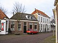 Building in Oost-Souburg
 Bridge in Oost-Souburg
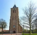 Church Open Haven
 Omroep Zeeland broadcasting station


References
- "Kerncijfers wijken en buurten 2021". Central Bureau of Statistics. Retrieved 23 April 2022.
- "Postcodetool for 4388AA". Actueel Hoogtebestand Nederland (in Dutch). Het Waterschapshuis. Retrieved 23 April 2022.
- "Oost-Souburg - (geografische naam)". Etymologiebank (in Dutch). Retrieved 23 April 2022.
- Piet van Cruyningen & Ronald Stenvert (2003). Oost-Souburg (in Dutch). Zwolle: Waanders. ISBN 90 400 8830 6. Retrieved 23 April 2022.
- "Oost-Souburg". Plaatsengids (in Dutch). Retrieved 23 April 2022.
- Ad van der Meer and Onno Boonstra, Repertorium van Nederlandse gemeenten, KNAW, 2011.
- "halte Oost Souburg". Stationsweb (in Dutch). Retrieved 23 April 2022.
- "station Vlissingen- Souburg". Stationweb (in Dutch). Retrieved 23 April 2022.
| Wikimedia Commons has media related to Oost-Souburg. |
Authority control | |
|---|---|
| General |
|
| National libraries | |
На других языках
[de] Oost-Souburg
Oost-Souburg (seeländisch Oôst-Soeburg) ist ein Ort zwischen Middelburg und Vlissingen in der niederländischen Provinz Zeeland. Oost-Souburg, von 1814 bis 1834 eine unabhängige Gemeinde, wurde 1834 mit West-Souburg, von dem es durch den Kanal durch Walcheren getrennt ist, zur Gemeinde Oost- en West-Souburg zusammengefügt, die 1966 nach Vlissingen eingemeindet wurde.- [en] Oost-Souburg
Другой контент может иметь иную лицензию. Перед использованием материалов сайта WikiSort.org внимательно изучите правила лицензирования конкретных элементов наполнения сайта.
WikiSort.org - проект по пересортировке и дополнению контента Википедии