world.wikisort.org - Netherlands
Rijnsaterwoude is a village in the Dutch province of South Holland. It is located about 6 km north of the town of Alphen aan den Rijn, in the municipality of Kaag en Braassem.
Rijnsaterwoude | |
|---|---|
Village | |
 Church: De Woudse Dom | |
 Rijnsaterwoude Location in the province of South Holland in the Netherlands  Rijnsaterwoude Location in the Netherlands | |
| Coordinates: 52°12′N 4°40′E | |
| Country | Netherlands |
| Province | South Holland |
| Municipality | Kaag en Braassem |
| Area | |
| • Total | 8.78 km2 (3.39 sq mi) |
| Elevation | −2.0 m (−6.6 ft) |
| Population (2021)[1] | |
| • Total | 1,200 |
| • Density | 140/km2 (350/sq mi) |
| Time zone | UTC+1 (CET) |
| • Summer (DST) | UTC+2 (CEST) |
| Postal code | 2465[1] |
| Dialing code | 0172 |
| Major roads | N207 |
History
The village was first mentioned in the first half of the 11th century as Rinsaterwalt, and means "forest of people who live along the (Oude) Rijn".[3] Rijnsaterwoude developed as a peat excavation settlement in the Middle Ages along the Braassemermeer.[4]
The Dutch Reformed church Woudse Dom is a single aisled church with built-in tower. The choir was built around 1500. The nave and tower were rebuilt are being damaged by a storm in 1552. The church was restored between 1956 and 1958.[4] The polder mill De Geestmolen was built in 1707. In 1960, the windmill sail broke and an electro motor was installed. In 1963, it was sold and restored in 1964. The wind mill is occasionally in service.[5]
Rijnsaterwoude was home to 561 people in 1840.[6] It was a separate municipality until 1991, when it became part of Jacobswoude.[7] In 2009, it became part of the municipality of Kaag en Braassem.[6]
Gallery
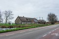 Farm in Rijnsaterwoude
 Windmill De Geestmolen


References
- "Kerncijfers wijken en buurten 2021". Central Bureau of Statistics. Retrieved 4 May 2022.
- "Postcodetool for 2465AA". Actueel Hoogtebestand Nederland (in Dutch). Het Waterschapshuis. 24 July 2019. Retrieved 4 May 2022.
- "Rijnsaterwoude - (geografische naam)". Etymologiebank (in Dutch). Retrieved 4 May 2022.
- Ronald Stenvert & Sabine Broekhoven (2004). "Rijnsaterwoude" (in Dutch). Zwolle: Waanders. ISBN 90-400-9034-3. Retrieved 4 May 2022.
- "De Geestmolen". Molen database (in Dutch). Retrieved 4 May 2022.
- "Rijnsaterwoude". Plaatsengids (in Dutch). Retrieved 4 May 2022.
- Ad van der Meer and Onno Boonstra, "Repertorium van Nederlandse gemeenten", KNAW, 2006. "KNAW > Publicaties > Detailpagina". Archived from the original on February 20, 2007. Retrieved December 3, 2009.
Другой контент может иметь иную лицензию. Перед использованием материалов сайта WikiSort.org внимательно изучите правила лицензирования конкретных элементов наполнения сайта.
WikiSort.org - проект по пересортировке и дополнению контента Википедии