world.wikisort.org - Netherlands
Oud Ade (also: Oud-Ade[3]) is a village in the Dutch province of South Holland. It is a part of the municipality of Kaag en Braassem, and lies about 7 km east of Leiden.
Oud Ade | |
|---|---|
Village | |
 Windmill (de Vrouw Vennemolen) with catholic church in the background | |
 Oud Ade Location in the province of South Holland in the Netherlands  Oud Ade Location in the Netherlands | |
| Coordinates: 52°11′N 4°34′E | |
| Country | Netherlands |
| Province | South Holland |
| Municipality | Kaag en Braassem |
| Area | |
| • Total | 1.63 km2 (0.63 sq mi) |
| Elevation | −1.9 m (−6.2 ft) |
| Population (2021)[1] | |
| • Total | 560 |
| • Density | 340/km2 (890/sq mi) |
| Time zone | UTC+1 (CET) |
| • Summer (DST) | UTC+2 (CEST) |
| Postal code | 2374[1] |
| Dialing code | 071 |
The village was first mentioned in 1395 or 1396 "Ecclesia de A". The current name means "the old river".[4] Oud Ade developed as a peat excavation settlement, but remained a small linear settlement. It developed into the village in the 1960s by the addition of planned neighbourhoods. The Catholic St Bavo Church was built in 1868.[3]
Gallery
 Catholic church and presbytery
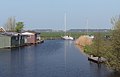 Panorama between Oud Ade and Warmond


References
- "Kerncijfers wijken en buurten 2021". Central Bureau of Statistics. Retrieved 4 May 2022.
combined with Zevenhuizen
- "Postcodetool for 2374AA". Actueel Hoogtebestand Nederland (in Dutch). Het Waterschapshuis. Retrieved 4 May 2022.
- "Oud-Ade". Plaatsengids (in Dutch). Retrieved 4 May 2022.
- "Oud-Ade - (geografische naam)". Etymologiebank (in Dutch). Retrieved 4 May 2022.
Authority control | |
|---|---|
| General |
|
| National libraries | |
This South Holland location article is a stub. You can help Wikipedia by expanding it. |
Текст в блоке "Читать" взят с сайта "Википедия" и доступен по лицензии Creative Commons Attribution-ShareAlike; в отдельных случаях могут действовать дополнительные условия.
Другой контент может иметь иную лицензию. Перед использованием материалов сайта WikiSort.org внимательно изучите правила лицензирования конкретных элементов наполнения сайта.
Другой контент может иметь иную лицензию. Перед использованием материалов сайта WikiSort.org внимательно изучите правила лицензирования конкретных элементов наполнения сайта.
2019-2026
WikiSort.org - проект по пересортировке и дополнению контента Википедии
WikiSort.org - проект по пересортировке и дополнению контента Википедии