world.wikisort.org - Netherlands
Reutum is a village in the Dutch province of Overijssel. It is a part of the municipality of Tubbergen, and lies about 10 km northwest of Oldenzaal.
Reutum | |
|---|---|
 St. Simon and Judas | |
 The town centre (dark green) and the statistical district (light green) of Reutum in the municipality of Tubbergen. | |
 Reutum Location in province of Overijssel in the Netherlands  Reutum Reutum (Netherlands) | |
| Coordinates: | |
| Country | Netherlands |
| Province | Overijssel |
| Municipality | Tubbergen |
| Area | |
| • Total | 15.43 km2 (5.96 sq mi) |
| Elevation | 26 m (85 ft) |
| Population (2021)[1] | |
| • Total | 1,405 |
| • Density | 91/km2 (240/sq mi) |
| Demonym(s) | Reutummers, Pinnsnieders |
| Time zone | UTC+1 (CET) |
| • Summer (DST) | UTC+2 (CEST) |
| Postal code | 7667[1] |
| Dialing code | 0541 |
Reutum was first attested in the late-10th century as Riatnon, and means "settlement near reed".[3] The village developed along the Reutumse Es.[4] Reutum and neighbour Haarle were home to 670 people in 1840.[5]
The church is dedicated to St. Simon and Judas, and was constructed in 1811.[4] The windmill is called "De Vier Winden" (The four winds), and dates from 1862.[4] Another point of interest is the double sluice in the Almelo-Nordhorn canal.
Notable people
- Bart Groothuis (born 1981), politician[6]
Gallery
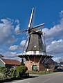 Windmill De Vier Winden
 Sluice in the Kanaal Almelo-Nordhorn


References
- "Kerncijfers wijken en buurten 2021". Central Bureau of Statistics. Retrieved 17 March 2022.
- "Postcodetool for 7667PA". Actueel Hoogtebestand Nederland (in Dutch). Het Waterschapshuis. Retrieved 17 March 2022.
- "Reutum - (geografische naam)". Etymologiebank (in Dutch). Retrieved 17 March 2022.
- Ronald Stenvert & Jan ten Hove (1998). "Reutum" (in Dutch). Zwolle: Waanders. ISBN 90 400 9200 1. Retrieved 16 March 2022.
- "Reutum". Plaatsengids (in Dutch). Retrieved 17 March 2022.
- "Drs. B. (Bart) Groothuis". Dutch Parliament (in Dutch). Retrieved 17 March 2022.
Wikimedia Commons has media related to Reutum.
This Overijssel location article is a stub. You can help Wikipedia by expanding it. |
Текст в блоке "Читать" взят с сайта "Википедия" и доступен по лицензии Creative Commons Attribution-ShareAlike; в отдельных случаях могут действовать дополнительные условия.
Другой контент может иметь иную лицензию. Перед использованием материалов сайта WikiSort.org внимательно изучите правила лицензирования конкретных элементов наполнения сайта.
Другой контент может иметь иную лицензию. Перед использованием материалов сайта WikiSort.org внимательно изучите правила лицензирования конкретных элементов наполнения сайта.
2019-2026
WikiSort.org - проект по пересортировке и дополнению контента Википедии
WikiSort.org - проект по пересортировке и дополнению контента Википедии