world.wikisort.org - Netherlands
Nieuwer-Ter-Aa is a village in the Dutch province of Utrecht (province). It is a part of the municipality of Stichtse Vecht, and lies about 13 km northwest of Utrecht.
Nieuwer-Ter-Aa | |
|---|---|
Village | |
 Street view | |
 Nieuwer-Ter-Aa Location in the Netherlands  Nieuwer-Ter-Aa Nieuwer-Ter-Aa (Netherlands) | |
| Coordinates: 52°11′28″N 4°58′55″E | |
| Country | Netherlands |
| Province | Utrecht |
| Municipality | Stichtse Vecht |
| Area | |
| • Total | 0.15 km2 (0.06 sq mi) |
| Elevation | 0 m (0 ft) |
| Population (2021)[1] | |
| • Total | 495 |
| • Density | 3,300/km2 (8,500/sq mi) |
| Time zone | UTC+1 (CET) |
| • Summer (DST) | UTC+2 (CEST) |
| Postal code | 3626[1] |
| Dialing code | 0294 |
History
The village was first mentioned in 1556 as Aade, and refers to the Aa River which is a tributary of the Angstel River. Nieuw (new) has been added to distinguish from Oud-Aa.[3] Nieuwer-Ter-Aa developed along the river which was the main route from Amsterdam to Utrecht. The river became obsolete after the Nieuwe Wetering was dug, and dammed near the church in 1527.[4]
Castle Ter Aa was located near the village, and was first described in 1106. The castle was destroyed by the French in 1673. In 1696, the estate Quackenburg was built in its place and was demolished in 1902. There are now residential houses at the site.[5] The tower of the Dutch Reformed Church dates from around 1400. The church in the late-15th century as a replacement of a 12th century church. It was restored in 1956.[4] In 1840, Nieuwer-Ter-Aar was home to 189 people spread over the municipalities Ruwiel and Loenersloot.[6]
The Oukoper Molen is a polder mill from 1644 which remove excess water from the polder. The wind mill was rebuilt in 1839 and served until 1961 when a Diesel powered pumping station rendered it obsolete.[7]
Gallery
 Oukoper Molen
 Farms in Nieuwer-Ter-Aa
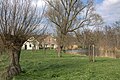 River Aa
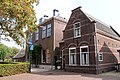 Clergy house


References
- "Kerncijfers wijken en buurten 2021". Central Bureau of Statistics. Retrieved 27 March 2022.
- "Postcodetool for 3626AA". Actueel Hoogtebestand Nederland (in Dutch). Het Waterschapshuis. Retrieved 27 March 2022.
- "Nieuwer Ter Aa - (geografische naam)". Etymologiebank (in Dutch). Retrieved 27 March 2022.
- Ronald Stenvert & Chris Kolman (1996). "Nieuwer-Ter-Aar" (in Dutch). Zwolle: Waanders. ISBN 90 400 9757 7. Retrieved 27 March 2022.
- "Ter Aa". Kastelen in Utrecht (in Dutch). Retrieved 27 March 2022.
- "Nieuwer Ter Aar". Plaatsengids (in Dutch). Retrieved 27 March 2022.
- "Oukoper Molen". Molen database (in Dutch). Retrieved 27 March 2022.
На других языках
[de] Nieuwer Ter Aa
Nieuwer Ter Aa ist ein niederländisches Dorf in der Gemeinde Stichtse Vecht, Provinz Utrecht und liegt an dem kleinen Fluss de Aa. Nach diesem sind „Nieuwer Ter Aa“ und „Oud Aa“ benannt. Der Ort zählt 725 Einwohner (Stand: 1. Januar 2020).[1] Viel deutet darauf hin, dass Nieuwer Ter Aa bereits seit 1000 Jahren besteht. Die spätgotische Dorfkirche aus dem 15. Jahrhundert (Bild) steht auf der Stelle einer älteren romanischen Kirche; in den Mauern aus Backstein sind deren Tuffsteine als Bände verarbeitet.[2] Vor 1964 gehörte das dorf den damaligen Gemeinden Ruwiel und Loenersloot, nachdem es bis 2011 zu Breukelen gehörte.- [en] Nieuwer-Ter-Aa
Другой контент может иметь иную лицензию. Перед использованием материалов сайта WikiSort.org внимательно изучите правила лицензирования конкретных элементов наполнения сайта.
WikiSort.org - проект по пересортировке и дополнению контента Википедии