world.wikisort.org - Netherlands
Portengen is a hamlet in the Dutch province of Utrecht. It is located in the municipality of Stichtse Vecht, 1 km (0.62 mi) northeast of Kockengen.
Portengen | |
|---|---|
Hamlet | |
 | |
 Portengen Location in the Netherlands  Portengen Portengen (Netherlands) | |
| Coordinates: 52°09′21″N 4°57′48″E | |
| Country | Netherlands |
| Province | Utrecht |
| Municipality | Stichtse Vecht |
| Area | |
| • Total | 6.87 km2 (2.65 sq mi) |
| Elevation | −0.5 m (−1.6 ft) |
| Population (2021)[1] | |
| • Total | 285 |
| • Density | 41/km2 (110/sq mi) |
| Time zone | UTC+1 (CET) |
| • Summer (DST) | UTC+2 (CEST) |
| Postal code | 3628[1] |
| Dialing code | 0346 |
Portengen was a separate municipality from 1818 to 1857, when it was merged with Breukelen-Nijenrode.[3]
The hamlet was first mentioned in 1217 as Britannien, and is a reference to Brittany, France. It started as a peat excavation colony during the 11th and 12th century.[4] The hamlet of Portengensebrug is an enclave within Portengen. In 1840, Portengen was home to 55 people.[5]
Gallery
 View on Portengensebrug
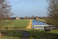
 Pumping station Dooijersluis
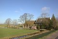 Farm in Portegen


References
- "Kerncijfers wijken en buurten 2021". Central Bureau of Statistics. Retrieved 27 March 2022.
- "Postcodetool for 3628AA". Actueel Hoogtebestand Nederland (in Dutch). Het Waterschapshuis. Retrieved 27 March 2022.
- Ad van der Meer and Onno Boonstra, Repertorium van Nederlandse gemeenten, KNAW, 2011.
- "Portengen - (geografische naam)". Etymologiebank (in Dutch). Retrieved 27 March 2022.
- "Portengen". Plaatsengids (in Dutch). Retrieved 27 March 2022.
Wikimedia Commons has media related to Portengen.
This Utrecht location article is a stub. You can help Wikipedia by expanding it. |
Текст в блоке "Читать" взят с сайта "Википедия" и доступен по лицензии Creative Commons Attribution-ShareAlike; в отдельных случаях могут действовать дополнительные условия.
Другой контент может иметь иную лицензию. Перед использованием материалов сайта WikiSort.org внимательно изучите правила лицензирования конкретных элементов наполнения сайта.
Другой контент может иметь иную лицензию. Перед использованием материалов сайта WikiSort.org внимательно изучите правила лицензирования конкретных элементов наполнения сайта.
2019-2026
WikiSort.org - проект по пересортировке и дополнению контента Википедии
WikiSort.org - проект по пересортировке и дополнению контента Википедии