world.wikisort.org - Netherlands
Marum (Dutch pronunciation: [ˈmaːrʏm] (![]() listen)) is a town and a former municipality in the northeastern Netherlands. The municipality was merged into the municipality of Westerkwartier on 1 January 2019.[3]
listen)) is a town and a former municipality in the northeastern Netherlands. The municipality was merged into the municipality of Westerkwartier on 1 January 2019.[3]
Marum | |
|---|---|
Town and former municipality | |
 Marum town hall | |
 Flag  Coat of arms | |
 Location in Groningen | |
 Marum Location in the province of Groningen in the Netherlands  Marum Marum (Netherlands) | |
| Coordinates: 53°9′N 6°16′E | |
| Country | Netherlands |
| Province | Groningen |
| Municipality | Westerkwartier |
| Merged | 2019 |
| Area | |
| • Total | 43.58 km2 (16.83 sq mi) |
| Elevation | 3 m (10 ft) |
| Population (2021)[1] | |
| • Total | 8,125 |
| • Density | 190/km2 (480/sq mi) |
| Time zone | UTC+1 (CET) |
| • Summer (DST) | UTC+2 (CEST) |
| Postcode | 9363[1] |
| Area code | 0594 |
History
Marum is located in the peat area, and was an agricultural village.[4] It was first mentioned in 1385 and probably means village near the lake.[5] In 1795, it was home to 351 people.[6]
Marum started to industrialise in the early 20th century,[7] the tram from Groningen to Drachten resulted in further growth.[4] The construction of the A7 motorway has resulted in the development of a suburban town.[7] In 2019, it ceased to be an independent municipality and was merged into Westerkwartier.[3]
Former population centres
Boerakker, Jonkersvaart, Lucaswolde, Marum, Niebert, Noordwijk, Nuis, De Wilp.
Notable people
Gallery
 Marum, reformed church
 Dutch Topographic map of the municipality of Marum, June 2015
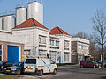 Dairy factory
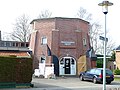 Base of a former windmill


References
- "Kerncijfers wijken en buurten 2021". Central Bureau of Statistics. Retrieved 7 March 2022.
- "Postcodetool for 9363BA". Actueel Hoogtebestand Nederland (in Dutch). Het Waterschapshuis. Archived from the original on 21 September 2013. Retrieved 30 January 2014.
- "Gemeentelijke indeling op 1 januari 2019". CBS (in Dutch). Retrieved 30 November 2019.
- Redmer Alma (1998). Marum (in Dutch). Zwolle: Waanders Uitgevers. p. 159. ISBN 90 400 9258 3. Retrieved 9 March 2022.
- "Marum". Etymologiebank (in Dutch). Retrieved 9 March 2022.
- Verdeling van de provintie van Stad en Lande (in Dutch). Groningen: Oomkens. 1796. p. 36. Retrieved 9 March 2022.
- "Marum". Plaatsengids (in Dutch). Retrieved 9 March 2022.
- "Tj.R. (Tjeerd) van Dekken". Dutch Parliament (in Dutch). Retrieved 9 March 2022.
- Bram Schierbeek (2018). "Aafje Looijenga-Vos (1928-2018)". International Union of Crystallography. Retrieved 9 March 2022.
External links
Places adjacent to Marum | ||||||||||||||||
|---|---|---|---|---|---|---|---|---|---|---|---|---|---|---|---|---|
| ||||||||||||||||
This Groningen location article is a stub. You can help Wikipedia by expanding it. |
На других языках
[de] Marum
Vorlage:Infobox Ort in den Niederlanden/Wartung/Typ falsch gesetzt- [en] Marum
[ru] Марюм
Марюм (нидерл. Marum (инф.)) — бывшая община на севере Нидерландов, в провинции Гронинген. Население Марюма на 1 января 2007 года составляло 10 061 человек[1]. Площадь общины 64,88km², из них 64,51km² земля, 0,37km² - водной поверхности. 1 января 2019 года Марюм вместе с общинами Гротегаст, Лек и Зёйдхорн были объединены в новую общину Вестерквартир.Другой контент может иметь иную лицензию. Перед использованием материалов сайта WikiSort.org внимательно изучите правила лицензирования конкретных элементов наполнения сайта.
WikiSort.org - проект по пересортировке и дополнению контента Википедии