world.wikisort.org - Netherlands
Lutten (Dutch Low Saxon: Luttn) is a village in the Dutch province of Overijssel. It is located in the municipality Hardenberg, about 13 kilometres (8.1 mi) south-west of Coevorden.[3]
Lutten | |
|---|---|
Village | |
 Dutch Reformed church | |
 Lutten Location in province of Overijssel in the Netherlands  Lutten Location in the Netherlands | |
| Coordinates: 52.6116°N 6.5747°E | |
| Country | Netherlands |
| Province | Overijssel |
| Municipality | Hardenberg |
| Area | |
| • Total | 12.18 km2 (4.70 sq mi) |
| Elevation | 8 m (26 ft) |
| Population (2021)[1] | |
| • Total | 2,045 |
| • Density | 170/km2 (430/sq mi) |
| Time zone | UTC+1 (CET) |
| • Summer (DST) | UTC+2 (CEST) |
| Postal code | 7775[1] |
| Dialing code | 0523 |
History
The village was first mentioned in 1532 as Lotten, and means "low lying place". There was another hamlet called Lutten nearby which changed its name to Oud-Lutten (Old Lutten).[4][5] Lutten developed during the peat excavation of the raised bog. The construction of the Dedemsvaart canal stagnated near Lutten around 1830, because the marke Ane had not divided up the wilderness in its area.[6] A marke was a form of government with communal land.[7] In 1832, the problem was solved by digging a canal to Slagharen.[6]
Lutten was home to 236 people in 1840.[8] The Dutch Reformed church is an aisleless church with an entrance hall topped by a tower with wooden roof lantern. It was built in 1853.[6] In 1901, the potato starch factory Baanbreker opened in Lutten. The complex is nowadays used by a plastic pipe factory.[6] In 1932, a water tower was built which measures 49 metres (161 ft). It is one of two Dutch water towers with a gable roof. The tower is nowadays used as bed and breakfast.[8]
Notable people
- Gert Heerkes (born 1965), football manager[9]
- Niek Kimmann (born 1996), BMX Racing cyclist and Olympic Champion[10]
Gallery
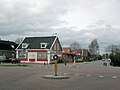 Centre of Lutten
 Water tower
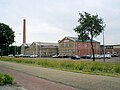 Former potato starch factory Baanbreker.
 Village house


References
- "Kerncijfers wijken en buurten 2021". Central Bureau of Statistics. Archived from the original on 22 December 2021. Retrieved 29 April 2022.
- "Postcodetool for 7775AA". Actueel Hoogtebestand Nederland (in Dutch). Het Waterschapshuis. Archived from the original on 25 December 2018. Retrieved 29 April 2022.
- "Distance Lutten, NLD -> Coevorden, NLD". Distance (in Dutch). Retrieved 29 April 2022.
- "Lutten - (geografische naam)". Etymologiebank (in Dutch). Retrieved 29 April 2022.
- "Oud-Lutten - (geografische naam)". Etymologiebank (in Dutch). Archived from the original on 21 March 2022. Retrieved 29 April 2022.
- Ronald Stenvert & Jan ten Hove (1998). "Lutten" (in Dutch). Zwolle: Waanders. ISBN 90 400 9200 1. Archived from the original on 17 March 2022. Retrieved 29 April 2022.
- "Boermarke". Geheugen van Drenthe (in Dutch). Archived from the original on 25 January 2022. Retrieved 29 April 2022.
- "Lutten". Plaatsengids (in Dutch). Archived from the original on 5 February 2022. Retrieved 29 April 2022.
- "G. Heerkes". Soccerway. Archived from the original on 16 February 2020. Retrieved 29 April 2022.
- "Niek Kimmann". Olympedia. Archived from the original on 26 April 2022. Retrieved 29 April 2022.
| Authority control |
|
|---|
Другой контент может иметь иную лицензию. Перед использованием материалов сайта WikiSort.org внимательно изучите правила лицензирования конкретных элементов наполнения сайта.
WikiSort.org - проект по пересортировке и дополнению контента Википедии