world.wikisort.org - Netherlands
Geesteren (Tweants: Geestern) is a village in the eastern Netherlands. It is located in the municipality of Tubbergen, Overijssel about 9 km northeast of Almelo.
Geesteren
Geestern (Twents) | |
|---|---|
Village | |
 St. Pancratius Church, Geesteren | |
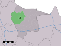 The village centre (dark green) and the statistical district (light green) of Geesteren in the municipality of Tubbergen. | |
 Geesteren Location in province of Overijssel in the Netherlands  Geesteren Geesteren (Netherlands) | |
| Coordinates: 52°25′N 6°44′E | |
| Country | Netherlands |
| Province | Overijssel |
| Municipality | Tubbergen |
| Area | |
| • Total | 31.90 km2 (12.32 sq mi) |
| Elevation | 17 m (56 ft) |
| Population (2021)[1] | |
| • Total | 4,325 |
| • Density | 140/km2 (350/sq mi) |
| Demonym(s) | Geesternaren, Papsleevn |
| Time zone | UTC+1 (CET) |
| • Summer (DST) | UTC+2 (CEST) |
| Postal code | 7678[1] |
| Dialing code | 0546 |
It was first mentioned in 1268 as Geysteren. The etymology is unclear.[3] Around 1800, it developed into a village around the Catholic church.[4] In 1840, Geesteren together with Harbrinkhoek and Langeveen were home to 1,329 people.[5] The Roman Catholic church, St. Pancratius, is named after Pancras of Rome, and dates from 1926.[4]
Every year an international concours hippique is organised at Erve Maathuis mainly focussing on show jumping. In 2019 this 'CSI Twente' celebrated its 45th anniversary.[5]
A landmark alongside the main road is the windmill 'Grote Geesterse Molen' which dates from 1867.[4]
Gallery
 Old style farmhouse with barn
 Monument for a vanished mill
 Grote Geesterse Molen
 Concours Hippique (1946)


References
- "Kerncijfers wijken en buurten 2021". Central Bureau of Statistics. Retrieved 17 March 2022.
- "Postcodetool for 7678AA". Actueel Hoogtebestand Nederland (in Dutch). Het Waterschapshuis. Retrieved 17 March 2022.
- "Geesteren - (geografische naam)". Etymologiebank (in Dutch). Retrieved 17 March 2022.
- Ronald Stenvert & Jan ten Hove (1998). "Geesteren" (in Dutch). Zwolle: Waanders. p. 147. ISBN 90 400 9200 1. Retrieved 17 March 2022.
- "Geesteren (Overijssel)". Plaatsengids (in Dutch). Retrieved 17 March 2022.
Другой контент может иметь иную лицензию. Перед использованием материалов сайта WikiSort.org внимательно изучите правила лицензирования конкретных элементов наполнения сайта.
WikiSort.org - проект по пересортировке и дополнению контента Википедии