world.wikisort.org - Netherlands
Geerdijk is a village in the Dutch province of Overijssel. It is located in the municipality of Twenterand. It became a village in 2009.
Geerdijk | |
|---|---|
Village | |
 Draw bridge at Geerdijk | |
 Geerdijk Location in the Netherlands  Geerdijk Geerdijk (Netherlands) | |
| Coordinates: 52.4756°N 6.5698°E | |
| Country | Netherlands |
| Province | Overijssel |
| Municipality | Twenterand |
| Area | |
| • Total | 4.52 km2 (1.75 sq mi) |
| Elevation | 10 m (30 ft) |
| Population (2021)[1] | |
| • Total | 995 |
| • Density | 220/km2 (570/sq mi) |
| Time zone | UTC+1 (CET) |
| • Summer (DST) | UTC+2 (CEST) |
| Postal code | 7681 & 7686[1] |
| Dialing code | 0546 |
History
Geerdijk was founded in the mid-19th century along the canal Almelo–De Haandrik as a peat excavation village.[3][4] It was a Catholic enclave which was settled by colonists from neighbouring Germany and the area around Slagharen and Dedemsvaart. In 1868, an independent parish was established.[4]
In 1906, the Geerdijk railway station opened on the Mariënberg–Almelo railway, and closed on 29 April 2016.[5] It was closed, because there were not enough passengers and Arriva wanted to increase the speed to allow an extension of the line to Hardenberg.[6]
Geerdijk used to be part of the municipality of Den Ham. In 2001, it was merged into Twenterand.[3] It was considered a hamlet of Vroomshoop. In 2009, Geerdijk separated from Vroomshoop, and became a village.[7]
Gallery
 Oldest extant house from 1878
 Church of Geerdijk
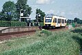 Geerdijk railway station
 Repos Ailleurs


References
- "Kerncijfers wijken en buurten 2021". Central Bureau of Statistics. Retrieved 18 March 2022.
Split in Oost and West; still added to the total population of Vroomshoop
- "Postcodetool for 7681AA". Actueel Hoogtebestand Nederland (in Dutch). Het Waterschapshuis. Retrieved 18 March 2022.
- "Ontstaan Twenterand". Canon van Nederland (in Dutch). Retrieved 18 March 2022.
- "Geerdijk". Plaatsengids (in Dutch). Retrieved 18 March 2022.
- "Station Geerdijk". Stationsweb (in Dutch). Retrieved 18 March 2022.
- "Station Geerdijk ligt in de weg". Trouw (in Dutch). 27 November 2015. Retrieved 18 March 2022.
- "Vroomschoop". Plaatsengids (in Dutch). Retrieved 18 March 2022.
This Overijssel location article is a stub. You can help Wikipedia by expanding it. |
Другой контент может иметь иную лицензию. Перед использованием материалов сайта WikiSort.org внимательно изучите правила лицензирования конкретных элементов наполнения сайта.
WikiSort.org - проект по пересортировке и дополнению контента Википедии