world.wikisort.org - Netherlands
Dodewaard is a village in the Dutch province of Gelderland. It is a part of the municipality of Neder-Betuwe, and lies about 7 km south of Wageningen.
Dodewaard | |
|---|---|
Village | |
 Remainder of the nuclear power plant | |
 Flag  Coat of arms | |
 Dodewaard Location in the Netherlands  Dodewaard Dodewaard (Netherlands) | |
| Coordinates: 51°55′N 5°39′E | |
| Country | Netherlands |
| Province | Gelderland |
| Municipality | Montferland |
| Area | |
| • Total | 19.32 km2 (7.46 sq mi) |
| Elevation | 8 m (26 ft) |
| Population (2021)[1] | |
| • Total | 4,465 |
| • Density | 230/km2 (600/sq mi) |
| Time zone | UTC+1 (CET) |
| • Summer (DST) | UTC+2 (CEST) |
| Postal code | 6669[1] |
| Dialing code | 0488 |
Dodewaard was a separate municipality until 2002, when it became a part of Kesteren. Before 1818, the municipality was called "Hien en Dodewaard".[3]
It also houses the now defunct Dodewaard nuclear power plant.
History
It was first mentioned in the 11th century de Dodeuuero, and means "land near water of Dudo/Dodo (person)".[4] Dodewaard developed along the Waal River as a stretched out settlement. The Dutch Reformed Church dates from around 1100. The tower was enlarged in the 12th and 16th century and replaced between 1840 and 1842.[5] In 1840, it was home to 714 people.[6]
The Dodewaard nuclear power plant was in service from 1969 until 1997. Most of the complex has been demolished, however the core remains and will not be dismantled until 2045 when the radio activity has been substantially reduced.[6]
Notable people
- Renger van der Zande (born 1986), race-car driver[7]
Gallery
 View on Dodewaard
 Villa Distelkamp
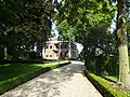 Former town hall
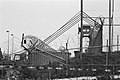 Fence around the nuclear power plant


References
- "Kerncijfers wijken en buurten 2021". Central Bureau of Statistics. Retrieved 23 March 2022.
- "Postcodetool for 6669AA". Actueel Hoogtebestand Nederland (in Dutch). Het Waterschapshuis. Retrieved 23 March 2022.
- Ad van der Meer and Onno Boonstra, Repertorium van Nederlandse gemeenten, KNAW, 2011.
- "Dodewaard - (geografische naam)". Etymologiebank (in Dutch). Retrieved 23 March 2022.
- Ronald Stenvert & Sabine Broekhoven (2000). "Didam" (in Dutch). Zwolle: Waanders. p. 139. ISBN 90 400 9406 3. Retrieved 23 March 2022.
- "Dodewaard". Plaatsengids (in Dutch). Retrieved 23 March 2022.
- "Van der Zande naar prachtige derde plaats op Daytona". Motorsport (in Dutch). Retrieved 23 March 2022.
Authority control | |
|---|---|
| General | |
| National libraries | |
This Gelderland location article is a stub. You can help Wikipedia by expanding it. |
Другой контент может иметь иную лицензию. Перед использованием материалов сайта WikiSort.org внимательно изучите правила лицензирования конкретных элементов наполнения сайта.
WikiSort.org - проект по пересортировке и дополнению контента Википедии