world.wikisort.org - Netherlands
Kesteren is a village in the Dutch province of Gelderland. It is a part of the municipality of Neder-Betuwe, and lies about 8 km southwest of Wageningen.
Kesteren | |
|---|---|
Village | |
 Kesteren, reformed church | |
 Flag Coat of arms | |
 Kesteren Location in the Netherlands  Kesteren Kesteren (Netherlands) | |
| Coordinates: 51°56′N 5°34′E | |
| Country | Netherlands |
| Province | Gelderland |
| Municipality | Montferland |
| Area | |
| • Total | 5.27 km2 (2.03 sq mi) |
| Elevation | 7 m (23 ft) |
| Population (2021)[1] | |
| • Total | 6,015 |
| • Density | 1,100/km2 (3,000/sq mi) |
| Time zone | UTC+1 (CET) |
| • Summer (DST) | UTC+2 (CEST) |
| Postal code | 4041[1] |
| Dialing code | 0488 |
Kesteren was a separate municipality until 2002, when it merged with Dodewaard and Echteld. The new municipality was first called "Kesteren", but changed its name to Neder-Betuwe in 2003.[3]
History
It was first mentioned in 850 as Castra, and is Latin for "army camp".[4] Kesteren developed along the Nederrijn as a linear settlement. The tower of the Dutch Reformed Church dates from the 14th century. The church was built around 1500, but was destroyed during World War II and rebuilt in 1951.[5] In 1840, it was home to 552 people.[6]
Transportation
Gallery
 Villa in Kesteren
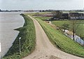 High water
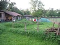 Nature camping
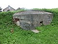 Bunker


References
- "Kerncijfers wijken en buurten 2021". Central Bureau of Statistics. Retrieved 23 March 2022.
two entries
- "Postcodetool for 4041AA". Actueel Hoogtebestand Nederland (in Dutch). Het Waterschapshuis. Retrieved 23 March 2022.
- Ad van der Meer and Onno Boonstra, Repertorium van Nederlandse gemeenten, KNAW, 2011.
- "Kesteren - (geografische naam)". Etymologiebank (in Dutch). Retrieved 23 March 2022.
- Ronald Stenvert & Sabine Broekhoven (2000). "Kesteren" (in Dutch). Zwolle: Waanders. p. 213. ISBN 90 400 9406 3. Retrieved 23 March 2022.
- "Kesteren". Plaatsengids (in Dutch). Retrieved 23 March 2022.
- "Station Kesteren". Stationsweb (in Dutch). Retrieved 23 March 2022.
This Gelderland location article is a stub. You can help Wikipedia by expanding it. |
Другой контент может иметь иную лицензию. Перед использованием материалов сайта WikiSort.org внимательно изучите правила лицензирования конкретных элементов наполнения сайта.
WikiSort.org - проект по пересортировке и дополнению контента Википедии