world.wikisort.org - Netherlands
Bunschoten (pronounced [ˈbʏnsxoːtə(n)] (![]() listen)) is a municipality and a town in the Netherlands, in the province of Utrecht. It lies about 7 km north of Amersfoort. Its territory comprises the original municipality of Bunschoten (created in 1204 by the bishop of Utrecht) and the former municipality of Duyst, De Haar and Zevenhuizen, which was a part of Hoogland from 1854 until 1971.
listen)) is a municipality and a town in the Netherlands, in the province of Utrecht. It lies about 7 km north of Amersfoort. Its territory comprises the original municipality of Bunschoten (created in 1204 by the bishop of Utrecht) and the former municipality of Duyst, De Haar and Zevenhuizen, which was a part of Hoogland from 1854 until 1971.
This article uses bare URLs, which are uninformative and vulnerable to link rot. (August 2022) |
Bunschoten | |
|---|---|
Municipality | |
 Countryside in Bunschoten | |
 Flag  Coat of arms | |
 Location in Utrecht | |
| Coordinates: 52°15′N 5°22′E | |
| Country | Netherlands |
| Province | Utrecht |
| Government | |
| • Body | Municipal council |
| • Mayor | Melis van de Groep (CU) |
| Area | |
| • Total | 34.81 km2 (13.44 sq mi) |
| • Land | 30.38 km2 (11.73 sq mi) |
| • Water | 4.43 km2 (1.71 sq mi) |
| Elevation | 0 m (0 ft) |
| Population (January 2019)[4] | |
| • Total | 21,576 |
| • Density | 710/km2 (1,800/sq mi) |
| Demonym | Bunschoter(s) |
| Time zone | UTC+1 (CET) |
| • Summer (DST) | UTC+2 (CEST) |
| Postcode | 3750–3754 |
| Area code | 033 |
| Website | www |

History
Bunschoten was first named in 1294. It was located on the border between Utrecht and Guelders, and it suffered a number of times from invasions from Guelders. In 1383, the bishop of Utrecht gave Bunschoten city rights, which allowed the citizens to build an earthen wall around the town. The fortifications and a part of the town were destroyed at Christmas 1427 in a war between two rival bishops, and were never rebuilt.
Population centres
The municipality of Bunschoten consists of the following cities, towns, villages and/or districts:
- Bunschoten
- Eemdijk
- Spakenburg
- Zevenhuizen
Notable people
- Bert Groen (born 1945) a Dutch politician, former Mayor of Bunschoten
- Melis van de Groep (born 1958 in Bunschoten) a Dutch politician, Mayor of Bunschoten since 2006
- Job Koelewijn (born 1962 in Spakenburg) a Dutch conceptual artist, sculptor, installation artist, performance artist and photographer
- Gijsbert Van Bismarck (born 1973 in Spakenburg) a retired footballer with over 150 club caps
- Kevin van Diermen (born 1989 in Spakenburg) a Dutch professional footballer with over 200 club caps
- Aileen de Graaf (born 1990 in Spakenburg) a Dutch darts player playing in the British Darts Organisation.[5]
Gallery
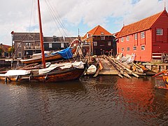 Old boat wharf of Spakenburg, 2013
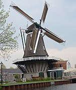 Rebuild (2009) flourmill De Hoop from 1899 at Bunschoten-Spakenburg
 Eem river at Eemdijk, looking north.
 Fishingboat at the Dock in Bunschoten at sunset
 Alice versus de Koning Peter de Leeuwe Bunschoten-Spakenburg


References
- "Samenstelling college" [Members of the board] (in Dutch). Gemeente Bunschoten. Archived from the original on 7 April 2014. Retrieved 5 April 2014.
- "Kerncijfers wijken en buurten 2020" [Key figures for neighbourhoods 2020]. StatLine (in Dutch). CBS. 24 July 2020. Retrieved 19 September 2020.
- "Postcodetool for 3752CL". Actueel Hoogtebestand Nederland (in Dutch). Het Waterschapshuis. Retrieved 5 April 2014.
- "Bevolkingsontwikkeling; regio per maand" [Population growth; regions per month]. CBS Statline (in Dutch). CBS. 1 January 2019. Retrieved 1 January 2019.
- http://www.aileendegraaf.com/
External links
 Media related to Bunschoten at Wikimedia Commons
- Official website
Municipalities of Utrecht | ||
|---|---|---|
 | ||
| ||
Authority control | |
|---|---|
| General |
|
| Other |
|
На других языках
[de] Bunschoten
Bunschoten ( anhören?/i) ist eine Gemeinde in den Niederlanden, Provinz Utrecht. Sie hat 22.329 Einwohner (Stand 1. Januar 2022). Ihre Gesamtfläche beträgt etwa 35 km². Sie besteht aus dem langgedehnten Zwillingsdorf Bunschoten-Spakenburg (Spakenburg ist der nördliche Teil, mit dem Fischereihafen am Eemmeer), und am Fluss Eem das kleine, durch eine Fähre erreichbare Bauerndorf Eemdijk.- [en] Bunschoten
Другой контент может иметь иную лицензию. Перед использованием материалов сайта WikiSort.org внимательно изучите правила лицензирования конкретных элементов наполнения сайта.
WikiSort.org - проект по пересортировке и дополнению контента Википедии