world.wikisort.org - Netherlands
Bladel (Dutch pronunciation: [ˈblaːdəl] (![]() listen)) is a municipality and town in the province of North Brabant, Southern Netherlands. In 2019, it had a population of 20,175.
listen)) is a municipality and town in the province of North Brabant, Southern Netherlands. In 2019, it had a population of 20,175.
Bladel | |
|---|---|
Municipality and town | |
 Townhall in Bladel | |
 Flag Coat of arms | |
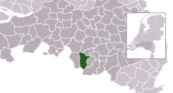 Location in North Brabant | |
| Coordinates: 51°22′N 5°13′E | |
| Country | Netherlands |
| Province | North Brabant |
| Established | 1 January 1997[1] |
| Government | |
| • Body | Municipal council |
| • Mayor | Remco Bosma (VVD) |
| Area | |
| • Total | 75.62 km2 (29.20 sq mi) |
| • Land | 75.33 km2 (29.09 sq mi) |
| • Water | 0.29 km2 (0.11 sq mi) |
| Elevation | 32 m (105 ft) |
| Population (January 2019)[4] | |
| • Total | 20,175 |
| • Density | 268/km2 (690/sq mi) |
| Time zone | UTC+1 (CET) |
| • Summer (DST) | UTC+2 (CEST) |
| Postcode | 5527–5534 |
| Area code | 0497 |
| Website | www |
Population centres
- Bladel
- Casteren
- Hapert
- Hoogeloon
- Netersel
Topography

Dutch Topographic map of the municipality of Bladel, 2013.
Notable residents

- Jan Renier Snieders (1812 in Bladel – 1888) a Flemish writer
- August Snieders (1825 in Bladel – 1904) a Flemish journalist and writer
- Corky de Graauw (born 1951 in Bladel) a former Dutch ice hockey player, competed at the 1980 Winter Olympics
- Alain van Katwijk (born 1979 in Bladel) a former Dutch cyclist
- Roy Beerens (born 1987 in Bladel) a Dutch professional footballer with 320 club caps
Gallery
 Tower former church
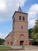 Antonius van Padua en Brigidakerk Netersel
 Overzicht - Hapert
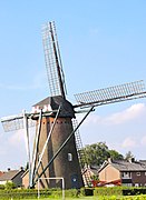 Hapertse molen
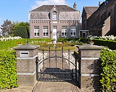 Pastorie bij de Sint-Willibrordkerk in Casteren
 Overzicht kapel gezien vanaf de andere kant van het water - Hoogeloon


References
- "Gemeentelijke indeling op 1 januari 1997" [Municipal divisions on 1 January 1997]. cbs.nl (in Dutch). CBS. Retrieved 26 May 2014.
- "Kerncijfers wijken en buurten 2020" [Key figures for neighbourhoods 2020]. StatLine (in Dutch). CBS. 24 July 2020. Retrieved 19 September 2020.
- "Postcodetool for 5531BC". Actueel Hoogtebestand Nederland (in Dutch). Het Waterschapshuis. Retrieved 1 May 2014.
- "Bevolkingsontwikkeling; regio per maand" [Population growth; regions per month]. CBS Statline (in Dutch). CBS. 1 January 2019. Retrieved 1 January 2019.
External links
 Media related to Bladel at Wikimedia Commons
- Official website
Places adjacent to Bladel | |
|---|---|
Municipalities of North Brabant | ||
|---|---|---|
|  | |
| ||
| Authority control |
|
|---|
This North Brabant location article is a stub. You can help Wikipedia by expanding it. |
Текст в блоке "Читать" взят с сайта "Википедия" и доступен по лицензии Creative Commons Attribution-ShareAlike; в отдельных случаях могут действовать дополнительные условия.
Другой контент может иметь иную лицензию. Перед использованием материалов сайта WikiSort.org внимательно изучите правила лицензирования конкретных элементов наполнения сайта.
Другой контент может иметь иную лицензию. Перед использованием материалов сайта WikiSort.org внимательно изучите правила лицензирования конкретных элементов наполнения сайта.
2019-2026
WikiSort.org - проект по пересортировке и дополнению контента Википедии
WikiSort.org - проект по пересортировке и дополнению контента Википедии