world.wikisort.org - Nepal
Kosi or Koshi (Nepali: कोसी अञ्चल, Nepali: कोशी अञ्चल ![]() Listen (help·info)) was one of the fourteen zones of Nepal until the restructure of zones to provinces. The headquarters of Kosi Zone was Biratnagar which was also its largest city. Other cities of Kosi Zone were Inaruwa, Dharan, Dhankutta, Jhumka, Duhabi and Itahari. Its main rivers were Arun, Tamor and Sapta Koshi.
Listen (help·info)) was one of the fourteen zones of Nepal until the restructure of zones to provinces. The headquarters of Kosi Zone was Biratnagar which was also its largest city. Other cities of Kosi Zone were Inaruwa, Dharan, Dhankutta, Jhumka, Duhabi and Itahari. Its main rivers were Arun, Tamor and Sapta Koshi.
This article relies largely or entirely on a single source. (January 2021) |
Kosi
कोसी अञ्चल[1] कोशी अञ्चल | |
|---|---|
Zone | |
 | |
| Country | |
| Population (2011) | |
| • Total | 2,335,047 |
| Time zone | UTC+5:45 (Nepal Time) |
Administrative subdivisions
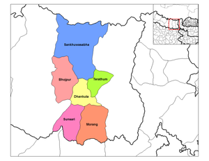
Kosi was divided into six districts; since 2015 these districts have been redesignated as part of Province No. 1.
| District | Type | Headquarters | Since 2015 part of Province |
|---|---|---|---|
| Bhojpur | Hill | Bhojpur | Province No. 1 |
| Dhankuta | Hill | Dhankuta | |
| Morang | Terai | Biratnagar | |
| Sankhuwasabha | Mountain | Khandbari | |
| Sunsari | Terai | Inaruwa | |
| Terhathum | Hill | Myanglung |
Famous and religious places
- Pindeswari Temple, Dharan
- Budha Subba Temple, Dharan
- Panchakanya Temple, Dharan
- Bishnupaduka Temple, Dharan
- Kali Mandir, Biratnagar
- Chintaangdevi Temple, Dhankuta
- Namaste Jharana, Vedetar
- Ramdhuni Mandir, Dhuni Ban
- Jhumkeshwar Mahadev, Jhumka
- Barahkshetra Mandir Barahachhetra
- Auliya Baba Mandir, Chatara
- Jabdi Mata Mandir, Pakali
- Betana Shimsar, Belbari [citation needed]
- Durgadevi Mandir, Laukahi
See also
- Development Regions of Nepal (Former)
- List of zones of Nepal (Former)
- List of districts of Nepal
References
- "कोसी". नेपाली बृहत शब्दकोश (in Nepali). Kathmandu: Nepal Academy.
Former Development regions and zones of Nepal (1982–2015) | ||
|---|---|---|
| Eastern Region (Purwanchal) | ||
| Central Region (Madhyamanchal) |
| |
| Western Region (Pashchimanchal) | ||
| Mid-Western Region (Madhya Pashchimanchal) | ||
| Far-Western Region (Sudur Pashchimanchal) | ||
Authority control | |
|---|---|
| General |
|
| National libraries | |
This article about a location in Province No. 1 of Nepal is a stub. You can help Wikipedia by expanding it. |
На других языках
- [en] Kosi Zone
[ru] Коси (зона Непала)
Коси (непальск. कोशी अञ्चल) — зона (территориальная единица) в восточной части Непала. Входит в состав Восточного региона страны. Административным центром является город Дхаран.Текст в блоке "Читать" взят с сайта "Википедия" и доступен по лицензии Creative Commons Attribution-ShareAlike; в отдельных случаях могут действовать дополнительные условия.
Другой контент может иметь иную лицензию. Перед использованием материалов сайта WikiSort.org внимательно изучите правила лицензирования конкретных элементов наполнения сайта.
Другой контент может иметь иную лицензию. Перед использованием материалов сайта WikiSort.org внимательно изучите правила лицензирования конкретных элементов наполнения сайта.
2019-2026
WikiSort.org - проект по пересортировке и дополнению контента Википедии
WikiSort.org - проект по пересортировке и дополнению контента Википедии