world.wikisort.org - Nepal
Dhaulagiri (Nepali: धौलागिरी अञ्चल ![]() Listen (help·info)) was one of the fourteen zones which Nepal was divided into for administrative purposes, prior to the September 10, 2015 adoption of a new Constitution, which divided the nation instead into 7 provinces. It is in the Western Development Region of Nepal and its headquarters are Baglung. Famous trekking areas like Mustang, Muktinath, Kali Gandaki valley and Mt Dhaulagiri fall in this zone. Dhorpatan Hunting Reserve, the only hunting reserve in Nepal is spread over Baglung and Myagdi Districts of this zone.
Listen (help·info)) was one of the fourteen zones which Nepal was divided into for administrative purposes, prior to the September 10, 2015 adoption of a new Constitution, which divided the nation instead into 7 provinces. It is in the Western Development Region of Nepal and its headquarters are Baglung. Famous trekking areas like Mustang, Muktinath, Kali Gandaki valley and Mt Dhaulagiri fall in this zone. Dhorpatan Hunting Reserve, the only hunting reserve in Nepal is spread over Baglung and Myagdi Districts of this zone.
Dhaulagiri Zone
धौलागिरी अञ्चल | |
|---|---|
Zone | |
 Dhaulagiri Zone | |
| Country | |
| Area | |
| • Total | 8,148 km2 (3,146 sq mi) |
| Population (2001) | |
| • Total | 556,191 |
| • Density | 68/km2 (180/sq mi) |
| Time zone | UTC+5:45 (Nepal Time) |
Administrative subdivisions
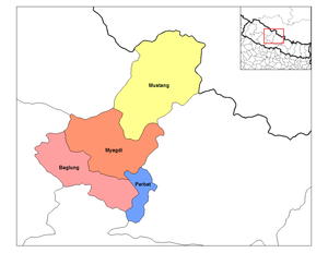
Dhaulagiri was divided into four districts; since 2015 these districts have been redesignated as part of Gandaki Province.
| District | Type | Headquarters | Since 2015 part of Province |
|---|---|---|---|
| Baglung | Hill | Baglung | Gandaki Province |
| Mustang | Mountain | Jomsom | |
| Myagdi | Hill | Beni | |
| Parbat | Hill | Kusma |

See also
- Development Regions of Nepal (Former)
- List of zones of Nepal (Former)
- List of districts of Nepal
Former Development regions and zones of Nepal (1982–2015) | ||
|---|---|---|
| Eastern Region (Purwanchal) |
| |
| Central Region (Madhyamanchal) |
| |
| Western Region (Pashchimanchal) |
| |
| Mid-Western Region (Madhya Pashchimanchal) |
| |
| Far-Western Region (Sudur Pashchimanchal) |
| |
This article about a location in Gandaki Province of Nepal is a stub. You can help Wikipedia by expanding it. |
На других языках
- [en] Dhaulagiri Zone
[ru] Дхаулагири (зона Непала)
Дхаулагири (непальск. धौलागिरी अञ्चल) — зона (административная единица) на северо-западе центральной части Непала. Входит в состав Западного региона страны. Административный центр — город Баглунг.Другой контент может иметь иную лицензию. Перед использованием материалов сайта WikiSort.org внимательно изучите правила лицензирования конкретных элементов наполнения сайта.
WikiSort.org - проект по пересортировке и дополнению контента Википедии