world.wikisort.org - Nepal
Jaljala (Nepali: जलजला गाउँपालिका) is a rural municipality in Parbat District of Gandaki Province, of Nepal.[1][2][3] It was mapped by merging the pre-existing rural development committees of Parbat District including Baskharka, Mallaj Majhphant, Lekhphant, Dhairing, Nagliwang, Banau and Salija.[4]
Jaljala Rural Municipality
जलजला गाउँपालिका | |
|---|---|
Rural Municipality | |
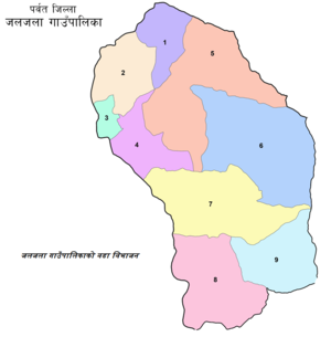 जलजला गाउँपालिकाको वडा विभाजन | |
 Jaljala Rural Municipality नेपालको नक्शामा जलजला गाउँपालिका  Jaljala Rural Municipality Jaljala Rural Municipality (Nepal) | |
| Coordinates (Mallaj): 28.34°N 83.58°E | |
| Country | |
| Province | Gandaki Province |
| District | Parbat District |
| Established | २७ Phalguna २०७३ |
| Government | |
| • Type | Local government |
| • Body | Village Executive |
| • Chairperson | यमबहादुर मल्ल (Nepali Congress) |
| • Vice-chairperson | सिमा पुन (नेपाली कांग्रेस) |
| • Chief executive officer | भिमप्रसाद अर्याल |
| Area | |
| • Total | 82.26 km2 (31.76 sq mi) |
| Population (2011 census) | |
| • Total | 21,454 |
| • Density | 260/km2 (680/sq mi) |
| Time zone | UTC+05:45 (Nepal Standard Time) |
| Area code | +९७७-६७ |
| Center | साविकको माझफाँट गाविसको कार्यालय |
The total population of this rural municipality is 21,454. Its area is 82.26 km square. The main office is located at the pre-existing head office of Mallaj Majhphant. The rural municipality is divided into 9 wards. The neighboring local authorities includes Modi rural municipality in the east, Myagdi and Parbat districts in the west, Myagdi District in the north and Kusma municipality and Baglung District in the south.[5]
References
- "Jaljala (Rural Municipality, Nepal) - Population Statistics, Charts, Map and Location". www.citypopulation.de. Retrieved 17 April 2020.
- "गाउँ र नगरपालिका कुन जिल्लामा कति ? (सूची)". Lokaantar (in Nepali). Retrieved 1 March 2019.
- "Setopati". Archived from the original on 12 March 2017.
- "गाउँ र नगरपालिका कुन जिल्लामा कति ? - Naya Patrika". Archived from the original on 2 November 2017. Retrieved 1 March 2019.
- "गाउँपालिका र नगरपालिका कायमगर्ने गरि उक्त एकाईहरुको नाम, संख्या, सीमाना, केन्द्र र वडाको सीमाना सहितको विवरण | | सङ्घीय मामिला तथा सामान्य प्रशासन मन्त्रालय". www.mofald.gov.np.
Parbat District | ||
|---|---|---|
Headquarters: Kushma | ||
| Municipalities |
|  |
| Rural municipalities | ||
| Former VDCs |
| |
This article about a location in Parbat District, Nepal is a stub. You can help Wikipedia by expanding it. |
Другой контент может иметь иную лицензию. Перед использованием материалов сайта WikiSort.org внимательно изучите правила лицензирования конкретных элементов наполнения сайта.
WikiSort.org - проект по пересортировке и дополнению контента Википедии