world.wikisort.org - Mali
Ségou Cercle is an administrative subdivision of the Ségou Region of Mali. The administrative center (chef-lieu) is the town of Ségou.
Ségou Cercle | |
|---|---|
Cercle | |
 Niger River at the village of Kalabougou near Ségou | |
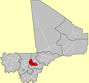 Location of the Cercle of Ségou in Mali | |
 Ségou Cercle | |
| Coordinates: 13°35′N 6°15′W | |
| Country | |
| Region | Ségou Region |
| Admin HQ (chef-lieu) | Ségou |
| Area | |
| • Total | 10,844 km2 (4,187 sq mi) |
| Population (2009 census)[2] | |
| • Total | 691,358 |
| • Density | 64/km2 (170/sq mi) |
| Time zone | UTC+0 (GMT) |
The cercle is divided into 30 communes:[3][4]
Different ethnicities are present in Ségou : Bambaras, Fula people, Miniankas, Bozos, Somonos, Dogons and Soninkés.
References
- Synthèsis des Plans de Securité Alimentaire des Communes du Cercle de Ségou 2008-2012 (PDF) (in French), Commissariat à la Sécurité Alimentaire, République du Mali, USAID-Mali, 2008, archived from the original (PDF) on 2011-09-06.
- Resultats Provisoires RGPH 2009 (Région de Ségou) (PDF) (in French), République de Mali: Institut National de la Statistique.
- Loi N°99-035/ du 10 Aout 1999 Portant Création des Collectivités Territoriales de Cercles et de Régions (PDF) (in French), Ministère de l'Administration Territoriales et des Collectivités Locales, République du Mali, 1999, archived from the original (PDF) on 2012-03-09.
- Communes de la Région de Ségou (PDF) (in French), Ministère de l’administration territoriale et des collectivités locales, République du Mali, archived from the original (PDF) on 2012-03-09. Names of communes are in upper-case without accents.
External links
- L'économie locale de Ségou: Rapport général (in French), Ministère des Affaires Étrangères des Pays-Bas, Organisation for Economic Co-Operation and Development (OECD), 2002 [2000].
- L'économie locale de Ségou: Comptes économiques locaux du Cercle de Ségou (in French), Organisation for Economic Co-Operation and Development (OECD), 2002 [2000].
This Ségou Region location article is a stub. You can help Wikipedia by expanding it. |
| Kayes Region |  | |
|---|---|---|
| Koulikoro Region | ||
| Sikasso Region | ||
| Ségou Region | ||
| Mopti Region | ||
| Tombouctou Region | ||
| Gao Region | ||
| Kidal Region | ||
| Bamako Capital District | ||
| Ménaka Region | ||
| Taoudénit Region | ||

Текст в блоке "Читать" взят с сайта "Википедия" и доступен по лицензии Creative Commons Attribution-ShareAlike; в отдельных случаях могут действовать дополнительные условия.
Другой контент может иметь иную лицензию. Перед использованием материалов сайта WikiSort.org внимательно изучите правила лицензирования конкретных элементов наполнения сайта.
Другой контент может иметь иную лицензию. Перед использованием материалов сайта WikiSort.org внимательно изучите правила лицензирования конкретных элементов наполнения сайта.
2019-2026
WikiSort.org - проект по пересортировке и дополнению контента Википедии
WikiSort.org - проект по пересортировке и дополнению контента Википедии