world.wikisort.org - Mali
Banamba Cercle is an administrative subdivision of the Koulikoro Region of Mali. Its seat is the town of Banamba, which is also its largest settlement. It lies at the center east of the region.
Banamba | |
|---|---|
Cercle | |
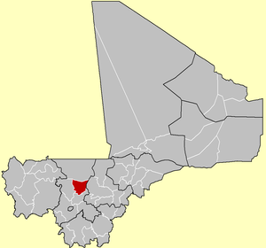 Location of Banamba Cercle in Mali | |
| Country | |
| Region | Koulikoro Region |
| Admin HQ (Chef-lieu) | Banamba |
| Area | |
| • Total | 7,500 km2 (2,900 sq mi) |
| Population (2009 census)[2] | |
| • Total | 190,235 |
| • Density | 25/km2 (66/sq mi) |
| Time zone | UTC+0 (GMT) |
Banamba Cercle is home to primarily Bambara farmers, and formed part of the pre-colonial Bambara Empire. The Cercle falls largely in the dryer Sahel region, especially in its north, where the population is mostly Fula and Maure pastoralists.
The Banamba Cercle is divided into nine rural communes:[3]
- Banamba (administrative seat and largest town)
- Ben Kadi
- Boron
- Duguwolowula
- Kiban
- Madina Sacko
- Sebete
- Toubacoro
- Toukoroba
References
- Synthèsis des Plans de Securité Alimentaire des Communes du Cercle Banamba 2008-2012 (PDF) (in French), Commissariat à la Sécurité Alimentaire, République du Mali, USAID-Mali, 2008, archived from the original (PDF) on 2011-07-26, retrieved 2011-02-02.
- Resultats Provisoires RGPH 2009 (Région de Koulikoro) (PDF) (in French), République de Mali: Institut National de la Statistique, archived from the original (PDF) on 2011-07-22.
- Communes de la Région de Koulokoro (PDF) (in French), Ministère de l’administration territoriale et des collectivités locales, République du Mali, archived from the original (PDF) on 2012-03-09.
| Kayes Region |  | |
|---|---|---|
| Koulikoro Region | ||
| Sikasso Region | ||
| Ségou Region | ||
| Mopti Region |
| |
| Tombouctou Region |
| |
| Gao Region | ||
| Kidal Region | ||
| Bamako Capital District | ||
| Ménaka Region | ||
| Taoudénit Region |
| |

This Koulikoro Region location article is a stub. You can help Wikipedia by expanding it. |
Текст в блоке "Читать" взят с сайта "Википедия" и доступен по лицензии Creative Commons Attribution-ShareAlike; в отдельных случаях могут действовать дополнительные условия.
Другой контент может иметь иную лицензию. Перед использованием материалов сайта WikiSort.org внимательно изучите правила лицензирования конкретных элементов наполнения сайта.
Другой контент может иметь иную лицензию. Перед использованием материалов сайта WikiSort.org внимательно изучите правила лицензирования конкретных элементов наполнения сайта.
2019-2026
WikiSort.org - проект по пересортировке и дополнению контента Википедии
WikiSort.org - проект по пересортировке и дополнению контента Википедии