world.wikisort.org - Kyrgyzstan
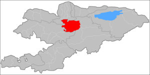
Jumgal (Kyrgyz: Жумгал району, romanized: Jumgal rayonu) is a district of Naryn Region in central Kyrgyzstan. The administrative seat lies at Chaek.[1] Its area is 4,803 square kilometres (1,854 sq mi),[2] and its resident population was 44,866 in 2021.[3] It is a mountainous district. Its main rivers are the Kökömeren (a tributary to the river Naryn) and its tributaries Jumgal, Suusamyr and Batysh Karakol.[4]
Jumgal
Жумгал району | |
|---|---|
District | |
 | |
| Country | Kyrgyzstan |
| Region | Naryn Region |
| Area | |
| • Total | 4,803 km2 (1,854 sq mi) |
| Population (2021) | |
| • Total | 44,866 |
| • Density | 9.3/km2 (24/sq mi) |
| Time zone | UTC+6 |
Population
| Year | Pop. | ±% p.a. |
|---|---|---|
| 1970 | 34,306 | — |
| 1979 | 41,493 | +2.14% |
| 1989 | 44,613 | +0.73% |
| 1999 | 40,902 | −0.86% |
| 2009 | 40,718 | −0.05% |
| 2021 | 44,866 | +0.81% |
| Note: resident population; Sources:[2][3] | ||
Populated places
In total, Jumgal District include 30 settlements in 13 rural communities (ayyl aymagy). Each rural community includes one or several villages. The rural communities and settlements in the Jumgal District are as follows:[1][5][6]
- Bash-Kuugandy (seat: Bash-Kuugandy)
- Bayzak (seat: Bayzak)
- Chaek (seat: Chaek; incl. Ak-Tatyr, Besh-Terek, Chukur-Akseki and Shorton)
- Chong-Döbö (seat: Chong-Döbö)
- Jangy-Aryk (seat: Jangy-Aryk; incl. Bazar-Turuk, Kyzart and Kyzyl-Emgek)
- Jumgal (seat: Jumgal; incl. Lama)
- Kabak (seat: Tabylgyty; incl. Aral, Keng-Suu, Kotur-Suu, Kyzyl-Korgon, Sary-Bulung and Tabylgy)
- Kök-Oy (seat: Kök-Oy; incl. Kichi-Aral)
- Kuyruchuk (seat: Kuyruchuk)
- Kyzyl-Jyldyz (seat: Kyzyl-Jyldyz)
- Ming-Kush (seat: Ming-Kush; incl. Kyzyl-Söök)
- Süyümbay (seat: Tash-Döbö)
- Tügöl-Say (seat: Tügöl-Say; incl. Epkin)

Bash-Kuugandy
Jangy-Aryk
Bazar-Turuk
Kyzyl-
Emgek
Emgek
Jumgal
Lama
Tabylgyty
Aral
Keng-
Suu
Suu
Kotur-Suu
Kyzyl-
Korgon
Korgon
Tabylgy
Kichi-Aral
Bayzak
Kuyruchuk
Tügöl-
Say
Say
Epkin
Tash-Döbö
Ak-Tatyr
Besh-Terek
Shorton
Chukur-Akseki
↓
↓
←Chaek
Kyzyl-Jyldyz
Kyzyl-Söök
Settlements of the Jumgal District
References
- "Classification system of territorial units of the Kyrgyz Republic" (in Kyrgyz). National Statistics Committee of the Kyrgyz Republic. May 2021. pp. 34–36.
- "2009 population and housing census of the Kyrgyz Republic: Naryn Region" (PDF) (in Russian). National Statistics Committee of the Kyrgyz Republic. 2010. pp. 12, 15.
- "Population of regions, districts, towns, urban-type settlements, rural communities and villages of Kyrgyz Republic" (XLS) (in Russian). National Statistics Committee of the Kyrgyz Republic. 2021. Archived from the original on 10 November 2021.
- "Жумгал району" [Jumgal District] (PDF). Кыргызстандын Географиясы [Geography of Kyrgyzstan] (in Kyrgyz). Bishkek. 2004. p. 506.
- List of Rural Communities of Kyrgyzstan Archived 2010-02-09 at the Wayback Machine
- Law 27 September 2012 No. 168 on the transformation of individual urban settlements of the Kyrgyz Republic and relating them to the category of village or city
| North Kyrgyzstan |
|  | ||||||||||
|---|---|---|---|---|---|---|---|---|---|---|---|---|
| South Kyrgyzstan |
| |||||||||||
This Naryn Region location article is a stub. You can help Wikipedia by expanding it. |
На других языках
- [en] Jumgal District
[ru] Жумгальский район
Жумгальский район (кирг. Жумгал району) — район Нарынской области Киргизии. Административный центр — село Чаек. Площадь — 7150 км².Текст в блоке "Читать" взят с сайта "Википедия" и доступен по лицензии Creative Commons Attribution-ShareAlike; в отдельных случаях могут действовать дополнительные условия.
Другой контент может иметь иную лицензию. Перед использованием материалов сайта WikiSort.org внимательно изучите правила лицензирования конкретных элементов наполнения сайта.
Другой контент может иметь иную лицензию. Перед использованием материалов сайта WikiSort.org внимательно изучите правила лицензирования конкретных элементов наполнения сайта.
2019-2026
WikiSort.org - проект по пересортировке и дополнению контента Википедии
WikiSort.org - проект по пересортировке и дополнению контента Википедии