world.wikisort.org - Kyrgyzstan
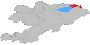
Tüp (Kyrgyz: Түп району) is a district of Issyk-Kul Region in north-eastern Kyrgyzstan. The seat lies at Tüp.[1] Its area is 2,121 square kilometres (819 sq mi),[2] and its resident population was 65,169 in 2021.[3] It borders Issyk-Kul District to the west, Ak-Suu District to the east and south-east, Kazakhstan to the north, and Issyk Kul to the south.
Tüp
Түп району | |
|---|---|
District | |
 Coat of arms | |
 | |
| Coordinates: 42°45′N 78°20′E | |
| Country | Kyrgyzstan |
| Region | Issyk-Kul |
| Area | |
| • Total | 2,121 km2 (819 sq mi) |
| Population (2021) | |
| • Total | 65,169 |
| • Density | 31/km2 (80/sq mi) |
| Time zone | UTC+6 |
Geography
The district is located between Küngöy Ala-Too Range and Issyk-Kul lake. The topography varies from multiple-folded medium-altitude mountains featuring in erosional dissection to alluvial - proluvial planes with river fans, and lakeside planes of Issyk-Kul lake area. Approximately 48% of the district is occupied by mountains, and 48% - by valleys. The hydrological conditions are dominated by Tüp river that rises on north slopes of Teskey Ala-Too Range. [4]
Climate
An average temperature in January is -6°C in valleys, and -14°C in mountains. In July, an average temperature varies from +18°C in valleys, to +9°C in mountains. An absolute recorded temperature maximum is +35°. Average maximum temperatures are +30°C in valleys, and +15°C in mountains. Average yearly precipitation is 350-400 mm in valleys, and 500-600 mm in mountains. An average snow cover is up to 30 cm. The Eastern wind called Santash reaches 20-30 m/s.[4]
Population
| Year | Pop. | ±% p.a. |
|---|---|---|
| 1970 | 46,940 | — |
| 1979 | 49,428 | +0.58% |
| 1989 | 53,119 | +0.72% |
| 1999 | 54,534 | +0.26% |
| 2009 | 58,786 | +0.75% |
| 2021 | 65,169 | +0.86% |
| Note: resident population; Sources:[2][3] | ||
Populated places
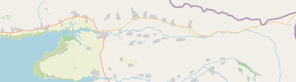
In total, Tüp District includes 37 settlements in 13 rural communities (ayyl aymagy). Each rural community may include one or several villages. The rural communities and settlements in the Tüp District are:[1][5][6]
- Ak-Bulak (seat: Ak-Bulak)
- Ak-Bulung (seat: Ak-Bulung; incl. Belovodskoye and Frunzenskoye)
- Aral (seat: Ming-Bulak; incl. Aral, Dolon, Kosh-Döbö and Sary-Döbö)
- Chong-Tash (seat: Chong-Tash; incl. Jyluu-Bulak)
- Karasaev (seat: Tasma; incl. Toktoyan and Chong-Toguz-Bay)
- Kuturgu (seat: Kuturgu; incl. Kichi-Örüktü, Oy-Bulak and Oy-Tal)
- Mikhaylovka (seat: Mikhaylovka)
- San-Tash (seat: Bayzak; incl. Karkyra, Keng-Suu, San-Tash and Sary-Tologoy)
- Sary-Bulak (seat: Balbay; incl. Kürmöntü)
- Taldy-Suu (seat: Taldy-Suu; incl. Ichke-Suu, Kööchü and Korumdu)
- Toguz-Bulak (seat: Toguz-Bulak; incl. Sary-Bulung)
- Tüp (seat: Tüp; incl. Birlik and Shaty)
- Ysyk-Köl (seat - village: Ysyk-Köl; incl. Yntymak)
Kosh-
Debe
Örüktü
Bulak
Tal
Frunzenskoe
Chong-
Toguz-
Bay
Bulak
References
- "Classification system of territorial units of the Kyrgyz Republic" (in Kyrgyz). National Statistics Committee of the Kyrgyz Republic. May 2021. pp. 15–16.
- "2009 population and housing census of the Kyrgyz Republic: Issyk-Kul Region" (PDF) (in Russian). National Statistics Committee of the Kyrgyz Republic. 2010. pp. 11, 16.
- "Population of regions, districts, towns, urban-type settlements, rural communities and villages of Kyrgyz Republic" (XLS) (in Russian). National Statistics Committee of the Kyrgyz Republic. 2021. Archived from the original on 10 November 2021.
- Мониторинг, прогнозирование опасных процессов и явлений на территории Кыргызской Республики [Monitoring and Forecasting of Natural Hazards in Kyrgyz Republic] (PDF) (in Russian) (18th ed.). Ministry of Emergency Situations of Kyrgyz Republic. 2021. p. 344. Retrieved May 20, 2021.
- List of Rural Communities of Kyrgyzstan Archived 2010-02-09 at the Wayback Machine
- Law 27 September 2012 No. 168 on the transformation of individual urban settlements of the Kyrgyz Republic and relating them to the category of village or city
| North Kyrgyzstan |
|  | ||||||||||
|---|---|---|---|---|---|---|---|---|---|---|---|---|
| South Kyrgyzstan |
| |||||||||||
This Issyk-Kul region location article is a stub. You can help Wikipedia by expanding it. |
На других языках
- [en] Tüp District
[ru] Тюпский район
Тюпский район (кирг. Түп району) — административная единица на северо-востоке Иссык-Кульской области Республики Киргизия. Образован 8 февраля 1935 года. Административный центр — село Тюп. Тюпский район — наименьшая административно-территориальная единица Иссык-Кульской области, граничит с Казахстаном.Другой контент может иметь иную лицензию. Перед использованием материалов сайта WikiSort.org внимательно изучите правила лицензирования конкретных элементов наполнения сайта.
WikiSort.org - проект по пересортировке и дополнению контента Википедии