world.wikisort.org - Japan
Urawa (浦和区, Urawa-ku) is one of ten wards of the city of Saitama, in Saitama Prefecture, Japan, and is located in the northeastern part of the city. Urawa-ku is the governmental center of Saitama City and houses most of the city's administrative offices including the city hall, as well as the offices of Saitama Prefectural government. Also, there are several newspaper branch offices and three broadcasting stations.
This article needs additional citations for verification. (January 2021) |
Urawa-ku, Saitama
浦和区 | |
|---|---|
Ward | |
| Urawa Ward | |
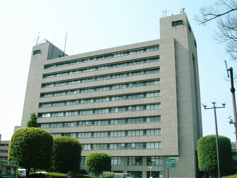 Saitama City Hall | |
 Location of Urawa-ku in Saitama | |
 Urawa-ku, Saitama | |
| Coordinates: 35°51′41.8″N 139°38′43.8″E | |
| Country | Japan |
| Region | Kantō |
| Prefecture | Saitama |
| City | Saitama |
| Area | |
| • Total | 11.51 km2 (4.44 sq mi) |
| Population (March 2021) | |
| • Total | 166,322 |
| • Density | 14,000/km2 (37,000/sq mi) |
| Time zone | UTC+9 (Japan Standard Time) |
| -Flower | Catharanthus roseus |
| Phone number | 048-835-3156 |
| Address | 6-4-1 Tokiwa, Urawa-ku, Saitama-shi, Saitama-ken 330-0586 |
| Website | Official website |
Geography
Urawa Ward is within the Ōmiya Plateau of the Kantō plain, in the south-central portion of Saitama City.
Neighboring Municipalities
Urawa-ku is surrounded by Midori-ku (to the east), Minami-ku (south), Chūō-ku (west), Ōmiya-ku (north), and Minuma-ku (northeast) of Saitama city.
History
In the Edo period, Urawa-ku flourished as Urawa-shuku, a post station on the Nakasendō highway, which connected Edo with Kyoto. Following the Meiji restoration, Urawa Prefecture was established, and in 1871 merged with Iwatsuki, Urawa, and Oshi Prefectures merged to form Saitama Prefecture, and Urawa as the capital. The modern town of Urawa was officially created within Kitaadachi District, Saitama with the establishment of the municipalities system on April 1, 1889.
After the 1923 Great Kantō earthquake many intellectuals, especially painters, moved to Urawa from Tokyo, Yokohama, and other cities in southern Kantō region. In 1932, Urawa annexed the neighboring villages of Yada and Kisaki, and was elevated to city status on February 11, 1934. Urawa expanded further by annexing the villages of Omagi and Mimuro on April 17, 1940 and town of Mutsuji on April 1, 1942. During World War II, Urawa was bombed twice by Allied forces in April and May 1945.
Urawa continued to expand after the end of the war, absorbing the villages of Tsuchiai and Okubo on January 1, 1955 and part of the town of Toda on April 1, 1959 and part of the village of Misono on May 1, 1962.
On May 1, 2001 Urawa merged with Ōmiya and Yono to form Saitama City. In April 2003 Saitama became a city designated by government ordinance, and now the area of former Urawa City was divided between Sakura-ku, Urawa-ku, Minami-ku, and Midori-ku.
Demographics
As of 1 March 2021[update], the ward had an estimated population of 166,322 and a population density of 14,000 persons per km². Its total area was 11.51 square kilometres (4.44 sq mi).[1]
Urawa has the second largest population of any ward in Saitama, only behind Minami-ku. The population density is the highest of all the city's wards. As of 2013, the proportion of households with an annual income of 10 million yen (about $102,459)[2] about or more is 15.3%. This is 13th largest of any city ward or municipality in Japan.[3]
As of 2010, university graduates account for 43.4% of the population age 25 or older. This ranks 15th in Japan.[4]
Education
Urawa-ku has 13 elementary schools, five middle schools, and six high schools.
The Embassy of South Korea in Tokyo maintains the Korea Education Institution (Korean: 사이타마한국교육원, Japanese: 埼玉韓国教育院) in Urawa Ward.[5]
Transportation
Railway
![]() – Tohoku Main Line / Takasaki Line
– Tohoku Main Line / Takasaki Line
![]() – Keihin Tohoku Line
– Keihin Tohoku Line
- Urawa - Kita-Urawa – Yono
Highway
 National Route 17
 National Route 463
Bus
- Tobu Bus West
- Seibu Bus
- International Kyogo Bus
Local attractions
- The Urawa Red Diamonds football (soccer) club in the J. League, arguably the biggest club in Japan and in Asia called the city home after strong support from its citizens. Although its official hometown recognized by the league is whole Saitama city and it is now the club is headquartered in Saitama Stadium in Midori-ku, the hometown support are strong in the area of former Urawa city. When the team has a match at Urawa Komaba Stadium in Urawa-ku or Saitama Stadium, the town becomes more and more crowded with the supporters.
References
- "Saitama city official statistics" (in Japanese). Japan.
- "Dollar Yen Exchange Rate (USD JPY) - Historical Chart". www.macrotrends.net. Retrieved 2021-08-09.
- "Labour Force Survey Employed persons 14 Employed person with previous job by type of household, age, industry of the present job, when left the previous job, industry of the previous job, duration of leaving a job (in the past 1 year) and in/decrease of income 2010 | File | Browse Statistics". Portal Site of Official Statistics of Japan. Retrieved 2021-08-09.
- "Population Census Item List 2010 | File | Browse Statistics". Portal Site of Official Statistics of Japan. Retrieved 2021-08-09.
- "Home". Korea Education Institution Saitama. Retrieved 2020-05-16.
4-16-7 Tokiwa, Urawa-ku, Saitama-shi, Saitama-ken, 330-0061(〒), Japan
External links
Official website (in Japanese)
Saitama (capital) | ||||
| Saitama |
| |||
| Core cities | ||||
| Special cities | ||||
| Cities | ||||
| Districts |
| |||
List of mergers in Saitama Prefecture | ||||
На других языках
[de] Urawa-ku (Saitama)
Urawa-ku (jap. 浦和区) ist ein Stadtbezirk (ku) der japanischen Stadt Saitama. Urawa liegt am Fluss Arakawa in der Nähe von Tokio, wo auch ein Großteil der Einwohner arbeitet.- [en] Urawa-ku, Saitama
Другой контент может иметь иную лицензию. Перед использованием материалов сайта WikiSort.org внимательно изучите правила лицензирования конкретных элементов наполнения сайта.
WikiSort.org - проект по пересортировке и дополнению контента Википедии