world.wikisort.org - Japan
Taketa (竹田市, Taketa-shi) is a city located in Ōita Prefecture, Japan. The city was founded on March 31, 1954. On April 1, 2005, the towns of Kujū, Naoiri and Ogi (all from Naoiri District) were also merged into Taketa. As of March 31, 2017, the city has an estimated population of 22,661, with 10,393 households and a population density of 47 persons per km².[1] The total area is 477.59 km².
This article needs additional citations for verification. (June 2018) |
Taketa
竹田市 | |
|---|---|
City | |
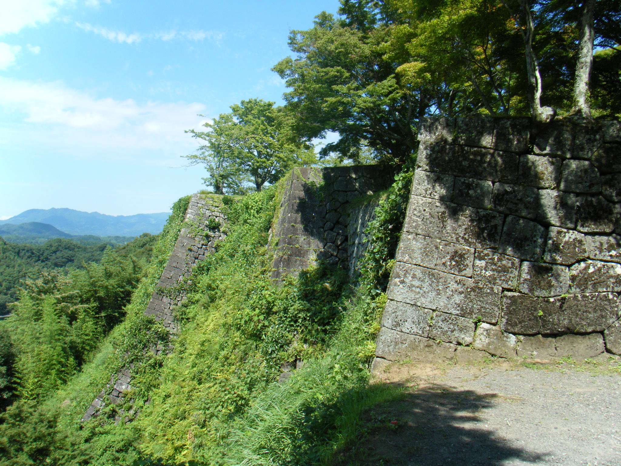 Oka Castle | |
 Flag  Seal | |
 Location of Taketa in Ōita Prefecture | |
 Taketa Location in Japan | |
| Coordinates: 32°58′N 131°24′E | |
| Country | Japan |
| Region | Kyushu |
| Prefecture | Ōita Prefecture |
| Government | |
| • Mayor | Katsuji Syuto (since April 2009) |
| Area | |
| • Total | 477.59 km2 (184.40 sq mi) |
| Population (March 31, 2017) | |
| • Total | 22,661 |
| • Density | 47/km2 (120/sq mi) |
| Time zone | UTC+09:00 (JST) |
| City hall address | Oji-Aiai 1650, Taketa City, Oita Prefecture (大分県竹田市大字会々1650番地) 878-8555 |
| Climate | Cfa |
| Website | www |
| Symbols | |
| Bird | Cettia diphone |
| Flower | Miyama Kirishima |
| Tree | Maple Leaf |
Oka Castle is a famous local historic site.
Geography
Climate
Taketa has a humid subtropical climate (Köppen climate classification Cfa) with hot summers and cool winters. Precipitation is significant throughout the year, but is somewhat lower in winter. The average annual temperature in Taketa is 14.7 °C (58.5 °F). The average annual rainfall is 1,885.3 mm (74.22 in) with June as the wettest month. The temperatures are highest on average in August, at around 25.7 °C (78.3 °F), and lowest in January, at around 3.9 °C (39.0 °F).[2] The highest temperature ever recorded in Taketa was 37.7 °C (99.9 °F) on 15 August 2020; the coldest temperature ever recorded was −8.6 °C (16.5 °F) on 10 February 1984.[3]
| Climate data for Taketa (1991−2020 normals, extremes 1977−present) | |||||||||||||
|---|---|---|---|---|---|---|---|---|---|---|---|---|---|
| Month | Jan | Feb | Mar | Apr | May | Jun | Jul | Aug | Sep | Oct | Nov | Dec | Year |
| Record high °C (°F) | 20.8 (69.4) |
25.0 (77.0) |
28.0 (82.4) |
29.8 (85.6) |
35.0 (95.0) |
33.9 (93.0) |
36.7 (98.1) |
37.7 (99.9) |
35.2 (95.4) |
31.7 (89.1) |
27.3 (81.1) |
23.5 (74.3) |
37.7 (99.9) |
| Average high °C (°F) | 9.0 (48.2) |
10.6 (51.1) |
14.4 (57.9) |
19.9 (67.8) |
24.3 (75.7) |
26.1 (79.0) |
30.4 (86.7) |
31.1 (88.0) |
27.2 (81.0) |
22.1 (71.8) |
16.8 (62.2) |
11.3 (52.3) |
20.3 (68.5) |
| Daily mean °C (°F) | 3.9 (39.0) |
5.0 (41.0) |
8.4 (47.1) |
13.6 (56.5) |
18.2 (64.8) |
21.3 (70.3) |
25.4 (77.7) |
25.7 (78.3) |
22.0 (71.6) |
16.5 (61.7) |
11.0 (51.8) |
5.8 (42.4) |
14.7 (58.5) |
| Average low °C (°F) | −0.9 (30.4) |
−0.3 (31.5) |
2.7 (36.9) |
7.5 (45.5) |
12.6 (54.7) |
17.4 (63.3) |
21.7 (71.1) |
21.7 (71.1) |
17.9 (64.2) |
11.5 (52.7) |
5.6 (42.1) |
0.7 (33.3) |
9.8 (49.7) |
| Record low °C (°F) | −8.4 (16.9) |
−8.6 (16.5) |
−7.2 (19.0) |
−3.2 (26.2) |
1.2 (34.2) |
7.7 (45.9) |
12.1 (53.8) |
13.8 (56.8) |
5.5 (41.9) |
0.2 (32.4) |
−3.4 (25.9) |
−8.2 (17.2) |
−8.6 (16.5) |
| Average precipitation mm (inches) | 48.1 (1.89) |
67.4 (2.65) |
103.6 (4.08) |
117.7 (4.63) |
147.8 (5.82) |
364.9 (14.37) |
309.7 (12.19) |
221.0 (8.70) |
268.6 (10.57) |
124.1 (4.89) |
67.6 (2.66) |
45.0 (1.77) |
1,885.3 (74.22) |
| Average precipitation days (≥ 1.0 mm) | 5.8 | 7.9 | 10.1 | 10.0 | 9.8 | 15.0 | 13.1 | 11.8 | 10.9 | 7.4 | 6.9 | 5.8 | 114.5 |
| Mean monthly sunshine hours | 159.9 | 151.3 | 170.3 | 188.1 | 194.9 | 131.7 | 174.2 | 193.5 | 144.8 | 165.6 | 153.8 | 160.6 | 1,988.6 |
| Source: Japan Meteorological Agency[3][2] | |||||||||||||
Demographics
Per Japanese census data, the population of Taketa in 2020 is 20,332 people.[4] Taketa has been conducting censuses since 1920.
| Year | Pop. | ±% |
|---|---|---|
| 1960 | 56,889 | — |
| 1965 | 49,308 | −13.3% |
| 1970 | 42,873 | −13.1% |
| 1975 | 38,359 | −10.5% |
| 1980 | 36,011 | −6.1% |
| 1985 | 34,693 | −3.7% |
| 1990 | 32,398 | −6.6% |
| 1995 | 30,368 | −6.3% |
| 2000 | 28,689 | −5.5% |
| 2005 | 26,534 | −7.5% |
| 2010 | 24,361 | −8.2% |
| 2015 | 22,332 | −8.3% |
| 2020 | 20,332 | −9.0% |
| Taketa population statistics[4] | ||
Notable people from Taketa
- Iwao Akiyama, former woodblock printmaker
- Korechika Anami, former general in the Imperial Japanese Army during World War II
- Kenji Anan, stage and film actor
- Takeo Hirose, former career officer in the Imperial Japanese Navy
- Otoya Kawano, Japanese voice actor
References
- "Official website of Taketa city" (in Japanese). Japan: Taketa City. Retrieved 19 April 2017.
- 気象庁 / 平年値(年・月ごとの値). JMA. Retrieved April 23, 2022.
- 観測史上1~10位の値(年間を通じての値). JMA. Retrieved April 23, 2022.
- Taketa population statistics
External links
 Media related to Taketa, Ōita at Wikimedia Commons
- Official website (in Japanese)
Ōita (capital) | ||
| Core city | ||
| Cities | ||
| Districts | ||
List of mergers in Ōita Prefecture | ||
Authority control | |
|---|---|
| General | |
| National libraries | |
| Other |
|
This Ōita Prefecture location article is a stub. You can help Wikipedia by expanding it. |
На других языках
[de] Taketa
Taketa (japanisch .mw-parser-output .Hani{font-size:110%}竹田市, -shi) ist eine Stadt in der Präfektur Ōita in Japan auf der Insel Kyūshū. Sie gehört zum Naoiri-Distrikt.- [en] Taketa, Ōita
[ru] Такета
Таке́та (яп. 竹田市 Такэта-си) — город в Японии, находящийся в префектуре Оита. Площадь города составляет 477,59 км²[1], население — 22 842 человека (1 августа 2014)[2], плотность населения — 47,83 чел./км².Другой контент может иметь иную лицензию. Перед использованием материалов сайта WikiSort.org внимательно изучите правила лицензирования конкретных элементов наполнения сайта.
WikiSort.org - проект по пересортировке и дополнению контента Википедии