world.wikisort.org - Japan
Kunisaki (国東市, Kunisaki-shi) is a small coastal city located in Ōita Prefecture, Kyushu, Japan. It is located on the Kunisaki Peninsula facing the Seto Inland Sea. Mostly covered by forests and farmlands, the peninsula is dotted with temples. The modern city of Kunisaki was founded on March 31, 2006, from the merger of the former town of Kunisaki, absorbing the towns of Aki, Kunimi and Musashi (all from Higashikunisaki District). [citation needed] As of March 31, 2017, the city has an estimated population of 29,098, with 13,223 households and a population density of 92/km2 (240/sq mi).[1] The total area is 317.84 km2 (122.72 sq mi). [citation needed]
This article needs additional citations for verification. (September 2014) |
Kunisaki
国東市 | |
|---|---|
City | |
 Kunisaki city hall | |
 Flag | |
 Location of Kunisaki in Ōita Prefecture | |
 Kunisaki Location in Japan | |
| Coordinates: 33°33′55″N 131°43′52″E | |
| Country | Japan |
| Region | Kyushu |
| Prefecture | Ōita Prefecture |
| Government | |
| • Mayor | Akifumi Mikawa (since March 2011) |
| Area | |
| • Total | 317.84 km2 (122.72 sq mi) |
| Population (March 31, 2017) | |
| • Total | 29,098 |
| • Density | 92/km2 (240/sq mi) |
| Time zone | UTC+09:00 (JST) |
| City hall address | 873-0501 |
| Climate | Cfa |
| Website | http://www.city.kunisaki.oita.jp |
| Symbols | |
| Bird | Green pheasant |
| Flower | Tenderstem broccoli |
| Tree | Cinnamomum camphora |
Oita Airport is located in Kunisaki.
History
Nuclear-free zone
On June 25, 2008, the City of Kunisaki declared itself a 'Nuclear-free Peace City" in wishing the abolition of nuclear weapons and world permanent peace.[2]
Geography
Located in northern Kyushu and the north east of Oita prefecture.
Mountains
- Mt. Futago (Futago-san) at 720m and the tallest
- Mt. Monju (Monju-san)
- Mt. Odomure
- Mt. Otake
- Mt. Takeshi Washinosu
- Mt. Fudo (or Hudo)
Climate
Kunisaki has a humid subtropical climate (Köppen climate classification Cfa) with hot summers and cool winters. Precipitation is significant throughout the year, but is somewhat lower in winter. The average annual temperature in Kunisaki is 16.2 °C (61.2 °F). The average annual rainfall is 1,641.6 mm (64.63 in) with June as the wettest month. The temperatures are highest on average in August, at around 27.3 °C (81.1 °F), and lowest in January, at around 6.1 °C (43.0 °F).[3] The highest temperature ever recorded in Kunisaki was 37.3 °C (99.1 °F) on 10 August 2013; the coldest temperature ever recorded was −7.9 °C (17.8 °F) on 8 January 2021.[4]
| Climate data for Kunimi, Kunisaki (1991−2020 normals, extremes 1977−present) | |||||||||||||
|---|---|---|---|---|---|---|---|---|---|---|---|---|---|
| Month | Jan | Feb | Mar | Apr | May | Jun | Jul | Aug | Sep | Oct | Nov | Dec | Year |
| Record high °C (°F) | 20.1 (68.2) |
24.1 (75.4) |
27.2 (81.0) |
29.9 (85.8) |
31.5 (88.7) |
34.0 (93.2) |
36.8 (98.2) |
37.3 (99.1) |
35.5 (95.9) |
31.6 (88.9) |
27.4 (81.3) |
27.0 (80.6) |
37.3 (99.1) |
| Average high °C (°F) | 9.9 (49.8) |
10.7 (51.3) |
14.1 (57.4) |
19.3 (66.7) |
23.9 (75.0) |
26.6 (79.9) |
30.7 (87.3) |
32.0 (89.6) |
28.3 (82.9) |
23.3 (73.9) |
17.8 (64.0) |
12.3 (54.1) |
20.7 (69.3) |
| Daily mean °C (°F) | 6.1 (43.0) |
6.6 (43.9) |
9.4 (48.9) |
14.1 (57.4) |
18.6 (65.5) |
22.2 (72.0) |
26.3 (79.3) |
27.3 (81.1) |
23.8 (74.8) |
18.7 (65.7) |
13.5 (56.3) |
8.4 (47.1) |
16.3 (61.3) |
| Average low °C (°F) | 2.4 (36.3) |
2.4 (36.3) |
4.8 (40.6) |
9.0 (48.2) |
13.8 (56.8) |
18.6 (65.5) |
22.9 (73.2) |
23.8 (74.8) |
20.2 (68.4) |
14.6 (58.3) |
9.4 (48.9) |
4.6 (40.3) |
12.2 (54.0) |
| Record low °C (°F) | −4.4 (24.1) |
−6.0 (21.2) |
−4.2 (24.4) |
0.4 (32.7) |
5.3 (41.5) |
9.7 (49.5) |
15.6 (60.1) |
16.4 (61.5) |
9.3 (48.7) |
4.6 (40.3) |
1.4 (34.5) |
−3.0 (26.6) |
−6.0 (21.2) |
| Average precipitation mm (inches) | 60.7 (2.39) |
70.2 (2.76) |
106.5 (4.19) |
123.2 (4.85) |
134.3 (5.29) |
274.6 (10.81) |
271.7 (10.70) |
154.1 (6.07) |
197.4 (7.77) |
113.5 (4.47) |
71.9 (2.83) |
63.5 (2.50) |
1,641.6 (64.63) |
| Average precipitation days (≥ 1.0 mm) | 8.3 | 8.7 | 10.1 | 9.5 | 9.1 | 13.0 | 11.0 | 8.7 | 9.9 | 6.7 | 7.6 | 8.7 | 111.3 |
| Mean monthly sunshine hours | 132.7 | 150.3 | 186.8 | 201.5 | 210.8 | 155.0 | 195.9 | 230.0 | 175.1 | 181.2 | 147.4 | 129.6 | 2,096.3 |
| Source: Japan Meteorological Agency[4][3] | |||||||||||||
| Climate data for Musashi, Kunisaki (2003−2020 normals, extremes 2003−present) | |||||||||||||
|---|---|---|---|---|---|---|---|---|---|---|---|---|---|
| Month | Jan | Feb | Mar | Apr | May | Jun | Jul | Aug | Sep | Oct | Nov | Dec | Year |
| Record high °C (°F) | 18.4 (65.1) |
23.7 (74.7) |
27.9 (82.2) |
27.0 (80.6) |
29.9 (85.8) |
34.2 (93.6) |
36.3 (97.3) |
36.3 (97.3) |
33.2 (91.8) |
32.2 (90.0) |
26.3 (79.3) |
24.2 (75.6) |
36.3 (97.3) |
| Average high °C (°F) | 9.9 (49.8) |
10.9 (51.6) |
13.6 (56.5) |
18.0 (64.4) |
21.8 (71.2) |
24.2 (75.6) |
28.0 (82.4) |
29.6 (85.3) |
27.1 (80.8) |
23.0 (73.4) |
17.9 (64.2) |
12.3 (54.1) |
19.7 (67.4) |
| Daily mean °C (°F) | 6.1 (43.0) |
7.0 (44.6) |
9.5 (49.1) |
13.8 (56.8) |
18.1 (64.6) |
21.4 (70.5) |
25.1 (77.2) |
26.7 (80.1) |
24.2 (75.6) |
19.5 (67.1) |
14.2 (57.6) |
8.5 (47.3) |
16.2 (61.1) |
| Average low °C (°F) | 1.9 (35.4) |
2.6 (36.7) |
5.0 (41.0) |
9.3 (48.7) |
14.2 (57.6) |
18.8 (65.8) |
22.8 (73.0) |
24.2 (75.6) |
21.3 (70.3) |
15.8 (60.4) |
10.1 (50.2) |
4.3 (39.7) |
12.5 (54.5) |
| Record low °C (°F) | −7.9 (17.8) |
−5.6 (21.9) |
−2.2 (28.0) |
0.5 (32.9) |
5.5 (41.9) |
11.8 (53.2) |
17.4 (63.3) |
18.0 (64.4) |
13.6 (56.5) |
8.0 (46.4) |
1.1 (34.0) |
−4.0 (24.8) |
−7.9 (17.8) |
| Average precipitation mm (inches) | 41.8 (1.65) |
65.8 (2.59) |
87.9 (3.46) |
122.8 (4.83) |
133.3 (5.25) |
269.2 (10.60) |
246.5 (9.70) |
130.0 (5.12) |
193.7 (7.63) |
123.3 (4.85) |
63.5 (2.50) |
57.9 (2.28) |
1,535.7 (60.46) |
| Average precipitation days (≥ 1.0 mm) | 5.9 | 7.9 | 8.5 | 9.0 | 8.2 | 12.4 | 10.5 | 7.6 | 9.3 | 6.3 | 6.4 | 7.0 | 99 |
| Source: Japan Meteorological Agency[5][6] | |||||||||||||
Geology
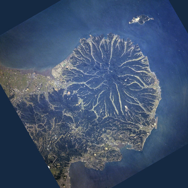
The Kunisaki Peninsula is formed from large conical volcanoes, including the 720-metre-tall (2,360 ft) Mt. Futago. Twenty-eight ravines radiate outward from the peninsula’s center.
Demographics
Per Japanese census data, the population of Kunisaki in 2020 is 26,232 people.[7] Kunisaki has been conducting censuses since 1920.
| Year | Pop. | ±% |
|---|---|---|
| 1950 | 65,370 | — |
| 1955 | 63,287 | −3.2% |
| 1960 | 58,786 | −7.1% |
| 1965 | 52,016 | −11.5% |
| 1970 | 46,521 | −10.6% |
| 1975 | 42,579 | −8.5% |
| 1980 | 40,504 | −4.9% |
| 1985 | 39,784 | −1.8% |
| 1990 | 37,771 | −5.1% |
| 1995 | 36,253 | −4.0% |
| 2000 | 35,425 | −2.3% |
| 2005 | 34,206 | −3.4% |
| 2010 | 32,007 | −6.4% |
| 2015 | 28,647 | −10.5% |
| 2020 | 26,232 | −8.4% |
| Kunisaki population statistics[7] | ||
Population data for Kunisaki, as of 30 September 2011
| Town | Male | Female | Total | No. of households |
|---|---|---|---|---|
| Kunisaki-machi | 5784 | 6435 | 12219 | 5153 |
| Kunimi-machi | 2287 | 2608 | 4895 | 2181 |
| Musashi-machi | 2716 | 2824 | 5540 | 2279 |
| Aki-machi | 4534 | 4869 | 9403 | 3826 |
| Totals | ||||
| Kunisaki-City | 15321 | 16736 | 32057 | 13439 |
Population distribution (2005 Census)

| National Population distribution by age(2005) | Age distribution by gender, for Kunisaki(2005) |
|---|---|
| ■ Purple - Kunisaki | ■ Blue - Men |
| ■ Green - Japan | ■ Red - Women |
Industry
The following major companies are based in Kunisaki.
- Canon Inc
- Sony Semiconductor Corporation
Education
Elementary schools
Kunisaki-machi
- Tomiku Elementary School
- Kunisaki Elementary School
- Owara Elementary School
- Asahi Elementary School
Musashi-machi
- Musashi Nishi Elementary School
- Musashi Higashi Elementary School
Aki-machi
- Aki Chuo Elementary School
- Aki Elementary School
Kunimi-machi
- Taketazu Elementary School
- Imi Elementary School
- Kumage SElementary School
Junior high schools
- Kunisaki Junior High School
- Musashi Junior High School
- Aki Junior High School
- Kunimi Junior High School
Transportation
Access
- 1 hr 30 mins by air from Tokyo Haneda airport to Oita airport
- 55 mins by air from Osaka Itami airport/Kansai International Airport to Oita airport
- 1 hr 10 mins from Nagoya Chubu International Airport to Oita airport
Tourism
- Gyonyu Dam and Lake Taro
Temples
- Futago-ji
- Monjusen-ji
- Senpuku-ji (also Sempuku-ji)
- Iwato-ji
- Ankoku-ji
- Joubutsu-ji
- Tomiku-ji
Notable people from Kunisaki
- Tatsumi Fujinami, Japanese professional wrestler
- Toyohiko Yoshida, former Japanese baseball pitcher (Nippon Professional Baseball)
References
- "Official website of Kunisaki city" (in Japanese). Japan: Kunisaki City. Retrieved 20 April 2017.
- "国東市非核平和都市宣言". Archived from the original on 2013-06-11. Retrieved 2013-05-24.
- 気象庁 / 平年値(年・月ごとの値). JMA. Retrieved April 22, 2022.
- 観測史上1~10位の値(年間を通じての値). JMA. Retrieved April 22, 2022.
- 観測史上1~10位の値(年間を通じての値). JMA. Retrieved April 22, 2022.
- 気象庁 / 平年値(年・月ごとの値). JMA. Retrieved April 22, 2022.
- Kunisaki population statistics
External links
Ōita (capital) | ||
| Core city | ||
| Cities | ||
| Districts | ||
List of mergers in Ōita Prefecture | ||
На других языках
[de] Kunisaki
Kunisaki (japanisch 国東市, -shi) ist eine Stadt in der Präfektur Ōita.- [en] Kunisaki
[ru] Кунисаки
Кунисаки (яп. 国東市 Кунисаки-си) — город в Японии, находящийся в префектуре Оита. Площадь города составляет 317,84 км²[1], население — 29 674 человека (1 августа 2014)[2], плотность населения — 93,36 чел./км².Другой контент может иметь иную лицензию. Перед использованием материалов сайта WikiSort.org внимательно изучите правила лицензирования конкретных элементов наполнения сайта.
WikiSort.org - проект по пересортировке и дополнению контента Википедии