world.wikisort.org - Japan
Nakatsu (中津市, Nakatsu-shi) is a city on the northern border of Ōita Prefecture in Kyushu, Japan. The city is on the border with Fukuoka Prefecture. Nakatsu was founded on April 20, 1929.[citation needed] As of March 2017, the city has an estimated population of 84,701 and a population density of 170 people per km2.[1] The total area is 491.09 km2.[citation needed]
This article includes a list of general references, but it lacks sufficient corresponding inline citations. (August 2012) |
Nakatsu
中津市 | |
|---|---|
City | |
 View of downtown Nakatsu, Nakatsu Castle | |
 Flag  Seal | |
 Location of Nakatsu in Ōita Prefecture | |
 Nakatsu Location in Japan | |
| Coordinates: 33°35′57″N 131°11′26″E | |
| Country | Japan |
| Region | Kyushu |
| Prefecture | Ōita Prefecture |
| First official recorded | 834 AD |
| City Settled | April 20, 1929 |
| Government | |
| • Mayor | Masakatsu Shingai |
| Area | |
| • Total | 491.09 km2 (189.61 sq mi) |
| Population (March 31, 2017) | |
| • Total | 84,701 |
| • Density | 170/km2 (450/sq mi) |
| Time zone | UTC+09:00 (JST) |
| City hall address | 14-3 Toyodamachi, Nakatsu-shi, Ōita-ken 871-8501 |
| Climate | Cfa |
| Website | www |
| Symbols | |
| Flower | Chrysanthemum |
| Tree | Round Leaf Holly (Ilex rotunda) |

History
- 1587: Kuroda Yoshitaka (Josui) built Nakatsu Castle as a flatland castle near the Yamaguni River.
- April 1925: The village of Ōe was merged with Toyoda to become the town of Nakatsu. [citation needed]
- April 1919: The village of Ogusu and the town of Nakatsu were merged to become the city of Nakatsu.
- August 1933: The villages of Tsurui, Ōhata and Josui were merged into Nakatsu. [citation needed]
- April 1951: The village of Miho was merged into Nakatsu.
- October 1954: The village of Wada was merged into Nakatsu.
- February 1955: The village of Imazu was merged into Nakatsu.
- March, 2005: The towns of Hon'yabakei, Yabakei and Yamakuni, and the village of Sankō (all from Shimoge District) were all merged into Nakatsu. [citation needed]
Geography
Nakatsu is in the northwest corner of Ōita Prefecture, Kyushu. To the east of Nakatsu is Usa and to the southwest is Hita. Nakatsu touches the border of Fukuoka Prefecture on its west. To the northeast is the Suohnada Sea. The city covers an area of 491.09 square kilometers, 80% of which is mountainous. There is a wide stretch of flat, agricultural land which begins at the mouth of Yamakuni River and extends to Mount Hiko called the Nakatsu plain. [2]
Climate
Nakatsu has a humid subtropical climate (Köppen climate classification Cfa) with hot summers and cool winters. Precipitation is significant throughout the year, but is somewhat lower in winter. The average annual temperature in Nakatsu is 16.3 °C (61.3 °F). The average annual rainfall is 1,574.1 mm (61.97 in) with June as the wettest month. The temperatures are highest on average in August, at around 27.9 °C (82.2 °F), and lowest in January, at around 5.8 °C (42.4 °F).[3] The highest temperature ever recorded in Nakatsu was 37.9 °C (100.2 °F) on 25 July 2013; the coldest temperature ever recorded was −5.5 °C (22.1 °F) on 24 January 2016.[4]
| Climate data for Nakatsu (2011−2020 normals, extremes 2011−present) | |||||||||||||
|---|---|---|---|---|---|---|---|---|---|---|---|---|---|
| Month | Jan | Feb | Mar | Apr | May | Jun | Jul | Aug | Sep | Oct | Nov | Dec | Year |
| Record high °C (°F) | 19.4 (66.9) |
23.8 (74.8) |
24.5 (76.1) |
29.7 (85.5) |
31.0 (87.8) |
36.1 (97.0) |
37.9 (100.2) |
36.8 (98.2) |
34.1 (93.4) |
31.7 (89.1) |
27.9 (82.2) |
25.7 (78.3) |
37.9 (100.2) |
| Average high °C (°F) | 9.7 (49.5) |
10.2 (50.4) |
14.2 (57.6) |
19.0 (66.2) |
24.0 (75.2) |
26.1 (79.0) |
30.4 (86.7) |
32.0 (89.6) |
27.5 (81.5) |
22.6 (72.7) |
17.5 (63.5) |
11.5 (52.7) |
20.4 (68.7) |
| Daily mean °C (°F) | 5.8 (42.4) |
6.1 (43.0) |
9.7 (49.5) |
14.2 (57.6) |
19.2 (66.6) |
22.4 (72.3) |
26.7 (80.1) |
27.9 (82.2) |
23.7 (74.7) |
18.6 (65.5) |
13.2 (55.8) |
7.5 (45.5) |
16.2 (61.3) |
| Average low °C (°F) | 2.0 (35.6) |
2.1 (35.8) |
5.2 (41.4) |
9.3 (48.7) |
14.4 (57.9) |
19.3 (66.7) |
23.7 (74.7) |
24.5 (76.1) |
20.5 (68.9) |
14.8 (58.6) |
9.0 (48.2) |
3.7 (38.7) |
12.4 (54.3) |
| Record low °C (°F) | −5.5 (22.1) |
−4.4 (24.1) |
−1.8 (28.8) |
0.6 (33.1) |
6.3 (43.3) |
12.8 (55.0) |
17.3 (63.1) |
18.0 (64.4) |
13.1 (55.6) |
7.3 (45.1) |
0.4 (32.7) |
−2.2 (28.0) |
−5.5 (22.1) |
| Average precipitation mm (inches) | 56.2 (2.21) |
70.2 (2.76) |
88.5 (3.48) |
98.3 (3.87) |
102.6 (4.04) |
289.5 (11.40) |
302.8 (11.92) |
146.0 (5.75) |
178.8 (7.04) |
133.0 (5.24) |
61.6 (2.43) |
59.1 (2.33) |
1,574.1 (61.97) |
| Average precipitation days (≥ 1.0 mm) | 5.7 | 8.6 | 8.3 | 9.1 | 7.1 | 12.2 | 10.9 | 8.8 | 9.6 | 7.5 | 7.2 | 7.5 | 102.5 |
| Mean monthly sunshine hours | 139.3 | 136.1 | 189.3 | 198.5 | 219.9 | 131.5 | 174.3 | 215.3 | 146.3 | 169.7 | 144.0 | 126.2 | 2,005 |
| Source: Japan Meteorological Agency[4][3] | |||||||||||||
Demographics
Per Japanese census data, the population of Nakatsu in 2020 is 82,863 people.[5] Nakatsu has been conducting censuses since 1920.
|
|
| ||||||||||||||||||||||||||||||||||||||||||||||||||||||||||||||||||||||||
| Nakatsu population statistics[5] | ||||||||||||||||||||||||||||||||||||||||||||||||||||||||||||||||||||||||||
Tourism
Nakatsu is a castle town centered on Nakatsu Castle, which is open to visitors. The modernised interior comprises a museum with samurai armor, old maps and information about Rangaku (Dutch studies), for which Nakatsu was an important center in the Edo period. There are views from the top of the castle keep. [citation needed]
Visitors can see the residence of the most celebrated member of the Okudaira clan of Nakatsu, Fukuzawa Yukichi, and the memorial hall there. It is close to the castle and a 15-minute walk from the station. [citation needed]
Nakatsu's Mt. Hachimen was home to the popular music festival, Concert on the Rock. [citation needed]
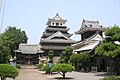 Nakatsu castle
 Fukuzawa Yukichi's former residence
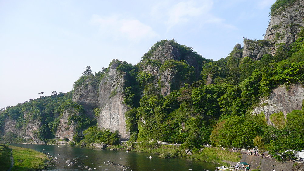
 Kyōshūhō Ridge, Yabakei
 Cave of Rakan-Temple (Rakanji), built on the middle cliff of Mt. Rakan


Notable people from Nakatsu
This section does not cite any sources. (December 2013) |
- Yoshijirō Umezu
- Fukuzawa Yukichi
- Fuyumi Ono
- Mai Matsumuro
- Risa Honda
See also
- Nakatsu Domain
- James Murdoch, author of the famous History of Japan who taught briefly in Nakatsu junior high school (1893) [citation needed]
References
- Nakatsushi-shi kankokai (Hrsg.): Nakatsu-shi (History of Nakatsu). Nakatsu: Nakatsushi-shi kankōkai, 1965 (中津市史刊行会編『中津市史』中津市史刊行会).
- Kuroya Naofusa: Nakatsuhan-shi (History of the Nakatsu Clan). Tōkyō: Kokusho kankōkai, 1987 (黒屋直房著『中津藩史』国書刊行会).
- "Official website of Nakatsu city" (in Japanese). Japan: Nakatsu City. Retrieved 19 April 2017.
- "山国川". Retrieved 1 October 2022.
- 気象庁 / 平年値(年・月ごとの値). JMA. Retrieved April 28, 2022.
- 観測史上1~10位の値(年間を通じての値). JMA. Retrieved April 28, 2022.
- Nakatsu population statistics
External links
- Nakatsu City official website (in Japanese)
- Nakatsu City official website (in English)
Ōita (capital) | ||
| Core city | ||
| Cities | ||
| Districts | ||
List of mergers in Ōita Prefecture | ||
Authority control | |
|---|---|
| General | |
| National libraries | |
| Scientific databases | |
| Other |
|
На других языках
[de] Nakatsu
Nakatsu (japanisch 中津市, -shi) ist eine Stadt in der Präfektur Ōita in Japan.- [en] Nakatsu, Ōita
[ru] Накацу
Накацу (яп. 中津市 Накацу-си) — город в Японии, находящийся в префектуре Оита. Площадь города составляет 491,17 км²[1], население — 84 082 человека (1 августа 2014)[2], плотность населения — 171,19 чел./км².Другой контент может иметь иную лицензию. Перед использованием материалов сайта WikiSort.org внимательно изучите правила лицензирования конкретных элементов наполнения сайта.
WikiSort.org - проект по пересортировке и дополнению контента Википедии