world.wikisort.org - Japan
Tagami (田上町, Tagami-machi) is a town located in Niigata Prefecture, Japan. As of 1 July 2019[update], the town had an estimated population of 11,481 in 4203 households,[1] and a population density of 362 persons per km². The total area of the town was 31.71 square kilometres (12.24 sq mi).
This article needs additional citations for verification. (October 2018) |
Tagami
田上町 | |
|---|---|
Town | |
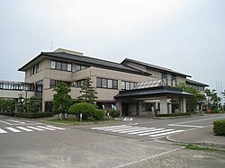
 Tagami town hall | |
 Flag  Seal | |
 Location of Tagami in Niigata | |
 Tagami | |
| Coordinates: 37°41′55.6″N 139°3′28.7″E | |
| Country | Japan |
| Region | Chūbu (Kōshin'etsu) (Hokuriku) |
| Prefecture | Niigata |
| District | Minamikanbara |
| Area | |
| • Total | 31.71 km2 (12.24 sq mi) |
| Population (July 1, 2019) | |
| • Total | 11,481 |
| • Density | 360/km2 (940/sq mi) |
| Time zone | UTC+9 (Japan Standard Time) |
| Symbols | |
| • Tree | Sakura |
| • Flower | Hydrangea macrophylla |
| Phone number | 0256-57-6222 |
| Address | 3070 Haragasaki Shinden, Tagami-machi, Minamikambara-gun, Niigata-ken 959-1503 |
| Website | Official website |
Geography
Tagami is located in central Niigata Prefecture, bordered by the city of Niigata to the north. The Shinano River flows through the town.
Surrounding municipalities
Climate
Tagami has a Humid climate (Köppen Cfa) characterized by warm, wet summers and cold winters with heavy snowfall. The average annual temperature in Tagami is 13.0 °C. The average annual rainfall is 1958 mm with September as the wettest month. The temperatures are highest on average in August, at around 26.3 °C, and lowest in January, at around 1.2 °C.[2]
Demographics
Per Japanese census data,[3] the population of Tagami peaked at around the year 2000 and has declined steadily since.
| Year | Pop. | ±% |
|---|---|---|
| 1970 | 9,534 | — |
| 1980 | 11,396 | +19.5% |
| 1990 | 12,761 | +12.0% |
| 2000 | 13,643 | +6.9% |
| 2010 | 12,791 | −6.2% |
| 2020 | 11,227 | −12.2% |
History
The area of present-day Tagami was part of ancient Echigo Province and was part of the tenryō territories administered directly by the Tokugawa shogunate during the Edo period.. The village of Tagami was established within Minamikanbara District, Niigata on April 1, 1889 with the creation of the modern municipalities system. Its as raised to town status on August 1, 1973.
Economy
The local economy is dominated by agriculture, notably rice production. However, the town is increasingly becoming a bedroom community for neighbouring Niigata city, Sanjo and Kamo.
Education
Tagami has two public elementary schools and one public middle school operated by the town government. There is no high school within town limits; however, the Niigata Chuoh Junior College is located in Tagami.
Transportation
Railway
![]() JR East - Shin'etsu Main Line
JR East - Shin'etsu Main Line
Highway
 National Route 403
References
External links
 Media related to Tagami, Niigata at Wikimedia Commons
- Official Website (in Japanese)
На других языках
- [en] Tagami, Niigata
[es] Tagami
Tagami (田上町, Tagami-machi?) es un pueblo en la prefectura de Niigata, Japón, localizado en la parte centro-oeste de la isla de Honshū, en la región de Chūbu. El 1 de marzo de 2021 tenía una población estimada de 11 200 habitantes y una densidad de población de 353 personas por km².[4][ru] Тагами
Тагами (яп. 田上町, たがみまち Тагами-мати) — посёлок в Японии, расположенный в центральной части префектуры Ниигата (уезд Минамикамбара). Основан 1 августа 1973 года путём реорганизации села Тагами. Площадь посёлка составляет 31,77 км²[1], население — 12 316 человек (1 августа 2014)[2], плотность населения — 387,66 чел./км².Другой контент может иметь иную лицензию. Перед использованием материалов сайта WikiSort.org внимательно изучите правила лицензирования конкретных элементов наполнения сайта.
WikiSort.org - проект по пересортировке и дополнению контента Википедии